

Access Guide
Introduction
- New Street is in the Town Centre of Retford. The A638 is connected to New Street. The A1M Motorway approximately 7.9 miles away. This guide covers the main shopping area of New Street. This guide runs from the A638 Arlington Way to the east, to Carolgate to the west. The route is approximately 0.5 miles (805m) and takes approximately 11-12 minutes to walk on average. The shopping area is on a slight to steep slope uphill from Victoria Street to Harpenden Road with some sections levelling out. Pathway surfaces are concrete paving slabs and block paving. The pathways have some uneven sections, which include some raised manhole covers. The road surfaces are tarmac, with dropped kerbs and tactile paving at most crossing points. There are opportunities to sit and rest.
Getting Here
- By Car:-
- The A1 is located approximately 6.2 miles away (10.1km) from New Street and Retford town centre
- New Street is located just off of the A638 Arlington Way
- New Street car park is located just off of New Street, on the right as you enter via Arlington Way.
- By Bus:-
- Retford Bus Station is located on Spa Road, which is close to New Street and Carolgate, at the centre of the street guide. The bus station is served by Stagecoach.
- For more information on buses available, please visit:-
- https://www.stagecoachbus.com/regional-service-updates/east-midlands/retford or
- https://www.nottinghamshire.gov.uk/transport/public-transport/bus-stations/retford-bus-station
- By Train:-
- The nearest railway station is Retford which is 0.6 miles away. This station has step free access to the platforms via lift.
- There are direct services available to Leeds, Lincoln, Newark, Doncaster, London, and Scotland.
- For more information on train services please refer to the following links:-
- https://www.northernrailway.co.uk/
- Northern Railway
- https://www.lner.co.uk/
- London North East Railway.
Parking
- Public Car Parks:-
- New Street public car park off of New Street is operated by Bassetlaw District Council.
- This is an open air car park.
- The surface of the car park is tarmac.
- There are 12 clearly marked and signposted Blue Badge bays and ample standard parking bays, as is shown in photographs 1 to 4.
- There are also similar public car parks on Carolgate, Chancery lane, Churchgate and Chapelgate.
- On Street Parking:-
- On Street Blue Badge bays and standard parking is located on New Street, shown in photographs 6 to 10.
- There is no charge for these parking bays.
- Parking is limited to 30 minutes for non Blue Badge holders Monday to Saturday 8:00 to 18:00.
- There is no return to these bays for 30 minutes during these times.
- Blue Badge holders may park in the Blue Badge parking bays for a maximum of 3 hours.
- There is similar Blue Badge parking and standard parking on Grove Street, Chapel Gate, and Church Gate, shown in photographs 11 to 16.
Junction - Arlington Way and New Street
- There is a pelican crossing on Arlington Way approximately 50m before the Arlington Way and New Street junction (shown in photographs 1 and 2).
- This pedestrian crossing has dropped kerbs with tactile paving on either side.
- The pedestrian crossings are push button controlled with visual signals and audible sounds when it is safe to cross.
- There is a very easy uphill slope (2.0 degrees maximum) on the pathway, on the New Street side, leading from the Pelican Crossing to the New Street Junction (shown in photograph 3).
- The pathway on both sides of the road is tarmac.
- There are some uneven surfaces on the pathway caused by tree roots, patches from repairs and manhole covers (shown in photographs 4 to 6).
- The distance from the Pelican Crossing to the Arlington Way and New Street junction is approximately 40m.
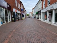
Arlington Way to Carolgate Via New Street
- The pathway on both sides of the road is tarmac (shown in photographs 1 and 2).
- The pathways on both sides are wide.
- There are uneven surfaces caused by pathway repairs, manhole covers and tree roots (shown in photographs 3 and 4).
- There is a very easy downhill slope on the pathway on either side of the road.
- There are some obstructions on either side of the road caused by overgrown trees, lampposts, and drainpipes (shown in Photographs 5 to 7).
- There are dropped kerbs crossing the path on both sides of the road, the dropped kerbs cause a narrowing of the pavement and there is a steep slope running from right to left or left to right, depending on which side of the road you are using (shown in photographs 8 and 9).
- Some of the dropped kerbs have tactile paving.
- There is a service road to cross on the left pavement for access to Jewson.
- This access road has a dropped kerb at either side (shown in photographs 10 to 12).
- The dropped kerbs do not have tactile paving.
- There is an access road to cross on the right pavement, giving access to New Street public car park (shown in photographs 13 to 14).
- The service road has a dropped kerb at the far side only.
- The near side has a 9cm kerb (shown in photograph 15).
- The dropped kerb on the far side does not have tactile paving.
- There are some Blue Badge Bays and standard parking bays on the left side of the road, towards the end. next to Jewson.
- After crossing the service road, or access road, continue along the pathway to Carolgate junction.
- This is not a bus route and there are no bus stops.
- Approximately 20m before the Carolgate junction, on the left pavement, there is an access road to the rear of the Jewson car park (shown in photographs 16 and 17).
- This access road has a dropped kerb on either side.
- The dropped kerb does not have tactile paving.
- Just past the access road to the Jewson rear car park, on the left pavement, the pavement width reduces to 83cm (shown in photograph 18).
- On the right pavement, there are dropped kerbs on the pavement to give car access to the front of some of the shops (shown in photograph 19).
- These dropped kerbs do not have tactile paving.
- On the right pavement, approximately 20m before the Carolgate junction, the pavement narrows to 120cm (shown in photograph 20).
- Whichever side pavement you use, the New Street and Carolgate Junction is now ahead (shown in photograph 21).
Junction - New Street to Carolgate
- There are no pedestrian crossings at this junction.
- At the New Street to Carolgate Junction you can turn left or right.
- Turning Left:-
- If turning left, there is a road with pavements on either side (shown in photograph 1).
- The road and pavement lead to Wharf Road.
- Turning right:-
- If turning right, there is a pedestrian area directly ahead (shown in photograph 2).
- The pedestrian area leads along Carolgate to Market Square.
Carolgate to Market Square Via Carolgate
- At the New Street to Carolgate Junction you can turn left or right.
- Turning left:-
- If turning left there is a road with pavements on either side.
- The pavement on the left is wide (photograph 2).
- The pavement on the left is level.
- The pavement on the left is tarmac.
- There are dropped kerbs on the left pavement. (As shown in photograph 3).
- The dropped kerbs do not have tactile paving.
- There are some obstructions on the left pavement caused by shop signage and street signs. (As shown in photographs 4 and 5).
- The pavement on the right is wide. (As shown in photograph 6).
- The pavement on the right is level.
- The pavement on the right consists of a mixture of concrete paving slabs and block paving.
- There are dropped kerbs on the pavement on the right. (As shown in photograph 6).
- The dropped kerbs do not have tactile paving.
- There are obstructions caused by lamp posts and drainage gutters. (as shown in photographs 8 and 9).
- The road continues for approximately 20m to Wharf Road.
- Turning right:-
- If turning right, there is a pedestrian area directly ahead. (As shown in photograph 10).
- The pedestrian area leads along Carolgate to Market Square.
- There is a dropped kerb just before the pedestrian area. (As shown in photograph 11).
- The dropped kerb does not have tactile paving.
- The pedestrian area is level.
- The pedestrian area consists of block paving in the centre and a mixture of block paving and concrete paving tiles to the left and right (photograph 12).
- Some of the block paving has large repeating patterns that could be perceived as steps or holes.
- There are lamp posts along the route that could cause a collision hazard (photograph 13).
- There is some bench seating along the route (photograph 14).
- There are some uneven surfaces created by manhole covers (photograph 15).
- There are bollards along the route to the left and right that could be a collision hazard (as shown in photograph 16).
- The bollards do have a good colour contrast with the pavement.
- Approximately 40m along Carolgate, the pavement changes to block paving only with drainage gutters at either side of the central walkway (photograph 17).
- Market square is now approximately 20m ahead (photograph 18).
Junction - Carolgate and Market Square
- The pedestrian area leading from Carolgate to Market Square changes from block paving to cobbles. (as shown in photographs 1 and 2).
- Turning left at this junction leads to the Market Square pedestrian area. (As shown in photograph 3).
- Turning right leads to the zebra crossing and the pavement to Churchgate and Chapelgate. (As shown in photograph 4).
- The cobbles are uneven.
- There is a zebra crossing at this junction on the corner of Grove Street and Market Square. (as shown in photographs 4 and 5).
- The pedestrian crossing is level with tactile paving at each side.
- The zebra crossing has beacons at either side.
- The beacons are clearly marked.
Market Square to Churchgate and Chapelgate Via Market Square
- The left side of Market Square is pedestrianised and consists of block paving and concrete paving tiles (shown in photograph 1).
- There is level access throughout the pedestrian area.
- There are bollards to enter the pedestrian area (shown in photographs 2 and 3).
- The bollards are 175cm wide.
- The bollards do have a good colour contrast with the paving.
- There is bench seating throughout the pedestrian area of Market Square (shown in photographs 4 and 5).
- There are some trees with raised paving in the pedestrian area of Market Square. The raised paving could create a trip hazard (shown in photographs 6 and 7).
- To continue to Churchgate and Chapelgate, take the zebra crossing on the right.
- At the far side of the crossing the pavement consists of a mixture of tactile paving, concrete and block paving (shown in photographs 8 to 10).
- There are uneven surfaces just past the zebra crossing created by drainage covers (shown in photograph 11).
- The pavement running along the right side of Market Square is wide (shown in photograph 12).
- The pavement consists of concrete paving slabs.
- The pavement is level but has a steep slope to the left to access the road (shown in photograph 13).
- There are uneven surfaces created by drainage covers (shown in photograph 14).
- There is a bus stop on either side of the road with a steep slope (shown in photographs 15 and 16).
- The pavement continues for approximately 40m to the junction with Churchgate and Chapelgate (shown in photograph 17).
Junction - Market Square to Churchgate and Chapelgate
- Churchgate and Chapel gate junction are ahead, at the end of Market Square (shown in photograph 1).
- There is level access at the junction.
- The junction surface is block paving and paving slabs (shown in photograph 2).
- There are bollards at the junction (shown in photographs 3 and 4).
- The bollards do contrast visibly with the paving.
- The bollards are 187cm wide.
Churchgate and Chapelgate Via Churchgate and Chapelgate
- The first 20m of Churchgate and Chapelgate is pedestrianised and consists of block paving and concrete paving tiles (shown in photograph 1).
- The block paving is to the centre and the paving tiles are to the left and right.
- There are some manhole covers creating uneven surfaces (shown in photograph 2).
- There is a camber with an easy slope on the block paving area (shown in photograph 3).
- The paving slabs are level.
- After the pedestrian area the road begins (shown in photograph 4).
- The right side road is Chapelgate.
- The left side road is Churchgate.
Accessible Toilet
- Accessible toilet facilities are not available.
-
Comments
View
- There are no public toilets available on the route but there are shops and restaurants that patrons may use along the way.
Standard Toilet(s)
-
Availability and Location of Standard Toilets
View
- Standard toilet facilities are not available.
-
Comments
View
- There are no public toilets available on the route but there are shops and restaurants that patrons may use along the way.
Access Guides Available For
-
Shopping
View
- Chancery Lane Car Park North - To view the access guide please click here (new tab).
- Chancery Lane Car Park South - To view the access guide please click here (new tab).
- Town Hall Council Services, Citizen’s Advice Bureau and Police Station - To view the access guide please click here (new tab).
- The Town Hall - To view the access guide please click here (new tab).