


Access Guide
Introduction
- The following information describes the route from Ollerton Road to Long Lane via Eldon Street and Newcastle Street.
- This route is approximately 0.3 miles in length (484 metres)
- The route takes the average person approximately 8-10 minutes to walk.
- The route does not have any direct bus stops, however, there are bus stops available on Lincoln Road and Newark Road, close to the centre of the route from either direction of travel.
- The surface of paths along the route consists of tarmac and block paving.
- The potential hazards on this route include; busy roads, congested pathways, steep slopes, and uneven pathways.
- The guide is split into the following sections:-
- 1. Junction of Ollerton Road and Eldon Street.
- 2. Ollerton Road via Eldon Street to Newark Road.
- 3. Junction of Eldon Road, Newark Road, Lincoln Road, and Newcastle Street.
- 4. Newark Road to Long Lane via Newcastle Street.
- 5. Junction of Long Lane and Newcastle Street.
Getting Here
- By Car
- The A1(M) is approximately 0.4miles away (645 metres) from the centre of the street guide (junction of Lincoln Road, Newark Road, and Eldon Street). This is via Ashvale Road and Lincoln Road.
- By Bus
- There is a bus stop available on Newark Road close to the centre of the street plan with direct services available to Newark and Retford.
- There is a bus stop available on Lincoln Road close to the centre of the street plan with direct service to North Muskham, Newark, Retford, and Caunton.
- For more information on the bus services available please refer to the following links:-
- https://www.stagecoachbus.com/about/east-midlands
- Stagecoach Buses
- https://www.nottinghamshire.gov.uk/transport/public-transport/nottsbus-connect
- Nottingham Buses
- By Train
- The nearest railway station is Retford which is 7 miles away. This station has step free access to the platforms via lift.
- There are direct services available to Leeds, Lincoln, Newark, Doncaster, London, and Scotland.
- For more information on trains available please refer to the following links:-
- https://www.northernrailway.co.uk/
- Northern Railway
- https://www.lner.co.uk/
- London North East Railway.
Parking
- Public Car Parks
- There is a free public car park on Ollerton Road (Tuxford Working Mens Club). This is at the north side of the street guide near to where Ollerton Road meets Eldon Street.
- The car park is free and available Monday to Saturday 9.00am to 17.00pm.
- The car park is for members of Tuxford Working Mens Club only outside of these hours.
- Photographs 1-5 show this car park.
- There is another free public car park on Newark Road opposite Mellors Garage to the south of the route near the junction with Newcastle Street and Newark Road.
- Photographs 6-9 show this car park.
- On Street Parking
- There is limited standard on street parking available on Eldon Street, Lincoln Road, Newark Road, and Newcastle Street. This is free with no marked restrictions.
- Photographs 10- 14 show examples of the on street parking.
1. Junction of Ollerton Road and Eldon Street
- There are several crossings at this junction to cross over Ollerton Road and Eldon Street
- These crossings only have dropped kerbs and no tactile paving on either side over Ollerton Road and Eldon Street.
- The surface of the roads is tarmac.
- The surface of the pathways is concrete and is uneven in places.
- There is a steep uphill slope leading from Ollerton Road into Eldon Street. There is a steep downhill slope right to left as you exit Ollerton Road onto Eldon Street.
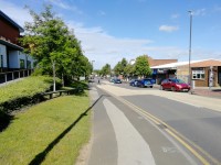
2. Ollerton Road via Eldon Street to Newark Road
- The pathways on both sides of the road in this section are formed of concrete and block paving.
- The pathways on both sides are wide but often narrow to less than 120cm to pass some bollards and signboards.
- There are some obstructions along the pavement on both sides such as signs, cash points, railings, cycle racks, bus stops, bins, and signboards.
- There is a slight to then steep uphill slope running from the Ollerton Road until you reach Premier Stores and the Post Office where it becomes a slight to steep downhill slope toward the junction of Eldon Street and Newark Road.
- There are some side roads/entrances to cross, and these are mainly level with the pathways. Some of the side roads/entrances have dropped kerbs without tactile paving.
- Photographs 1, 5, 6, and 9 show examples of these.
- There are no bus stops available on either side of the road.
3. Junction of Eldon Road, Newark Road, Lincoln Road, and Newcastle Street
- There are several crossings at this junction to cross over Lincoln Road, Newark Road, Newcastle Road, and Eldon Street.
- The crossing over Eldon Street is a zebra crossing that has dropped kerbs and tactile paving on both sides. Photographs 1 and 2 show this crossing.
- The crossing over Lincoln Road and Newark Road has no dropped kerbs or tactile paving. Photograph 3 and 4 shows this crossing.
- The crossing over Newcastle Street has dropped kerbs and tactile paving on both sides. Photographs 5 and 6 show this crossing.
- The surface of the roads is tarmac.
- The surface of the pathways is block paving and concrete and is uneven in places.
- There is a steep uphill slope leading from Eldon Street into Lincoln Road and a slight uphill slope leading from Newark Road and Newcastle Street.
- There is seating available at this junction on both sides of the road outside KSR Accountants and Sally Mitchell Gallery.
- There is a nearby bus stop available on Newark Road.
4. Newark Road to Long Lane via Newcastle Street
- The pathways on both sides of the road in this section are formed of concrete tiles/block paving.
- The pathways on both sides are often narrow to less than 120cm on both sides to pass some signboards, planters, and lamposts along the pathways.
- There are some obstructions along the pavement on both sides such as signs, bins, lampposts and signboards.
- There is a slight uphill slope running from the Newark Road along Newcastle Street towards Long Lane.
- There are some side roads/entrances to cross.
- Most of the side roads/entrances are level with the pathways.
- Some side roads/entrances have dropped kerbs and no tactile paving.
- There are no bus stops available on both sides of the road.
5. Junction of Long Lane and Newcastle Street
- There are several crossings at this junction to cross over Long Lane and Newcastle Street.
- The crossings over Newcastle Street do not have dropped kerbs or tactile paving on both sides.
- Photographs 1, 2, and 3 show the crossing over Newcastle Street. Photographs 4, 5, and 6 show the crossing over Long Lane.
- The crossing over Long Lane has dropped kerbs but no tactile paving.
- The crossing over Newcastle Street has dropped kerbs and tactile paving on both sides.
- The surface of the roads is tarmac.
- The surface of the pathways is concrete and is uneven in places.
- There is a slight uphill slope leading from Long Lane into Newcastle Street and a slight uphill slope right to left leading from Long Lane into Newcastle Street.
Accessible Toilet
- Accessible toilet facilities are not available.
-
Comments
View
- There are not any toilets available on the route but there are shops and restaurants that patrons may use along the way.
Standard Toilet(s)
-
Availability and Location of Standard Toilets
View
- Standard toilet facilities are not available.
-
Comments
View
- There are not any toilets available on the route but there are shops and restaurants that patrons may use along the way.