


Access Guide
Introduction
- The following information describes the shopping area from Westgate to Watson Road via Bridge Street and Bridge Place.
- This route is approximately 0.5 miles (805m).
- The route takes approximately 12-18 minutes to walk.
- The route leads you past several bus stops on nearby roads; such as Westgate and Newcastle Street
- The surface of paths along the route consists of tarmac and block paving, and is a mixture of pedestrian only and main roads.
- The potential hazards on this route include; busy roads, side roads, congested pathways, steep and slight slopes, several crossing points, and uneven pathways.
- The guide is split into the following sections:-
- 1. Junction – Westgate and Bridge Street.
- 2. Westgate to Potter Street via Bridge Street.
- 3. Junction – Potter Street, Bridge Place and Bridge Street.
- 4. Potter Street to Newcastle Avenue via Bridge Place.
- 5. Junction – Bridge Place and Newcastle Avenue
- 6. Newcastle Avenue to Ryton Street via Bridge Place
- 7. Junction – Ryton Street and Bridge Place
- 8. Ryton Street to Watson Road via Bridge Place
- 9. Junction – Watson Road and Bridge Place.
Getting Here
- By Car
- The shopping area surveyed is located mainly on Bridge Place and Bridge Street which is approximately 0.6 miles from the A57.
- The A57 gives you direct links north to the M1 and direct links southeast to the A1 via Newcastle Avenue at the centre of the shopping area surveyed.
- By Bus
- There are several bus stops on nearby roads around the shopping area such as Westgate and Market Place at the southern end of the route, Newcastle Avenue at the centre of the route and Watson Road at the north end of the route, with direct links available to Chesterfield, Kilton, Manton, and Nottingham.
- For Information on Stagecoach Buses see the following link:-
- https://www.stagecoachbus.com/about/east-midlands
- By Train
- Worksop Station is approximately 0.4 miles away from the northern end of the shopping area surveyed where Bridge Street meets Watson Road.
- There are direct services to Leeds, Lincoln, Sheffield, and Nottingham.
- There is step-free access to all platforms by ramps/slopes.
- Staff are available to assist with boarding via ramps.
- For more information on East Midlands Railway see the following link:-
- https://www.eastmidlandsrailway.co.uk/
- For more information on Northern Railway see the following link:-
- https://www.northernrailway.co.uk/.
Parking
- Public Car Parks
- Newgate Street Car Park is just off Bridge Street close to the junction with Westgate and has 8 Blue Badge parking bays and plenty of standard bays as shown in photographs 1-6. This is a pay and display or payable via an app called RingGo.
- Priory Shopping Centre Car Park is just off Bridge Place close to Priory Shopping Centre and has 10+ Blue Badge parking bays, 4 Parent and Baby parking bays, and plenty of standard parking bays. This is a pay and display or payable via an app called RingGo. Photographs 7-11 show the parking.
- On Street Parking
- Blue Badge parking is available on some sections of Bridge Street close to the junction with Westgate and on Newcastle Avenue. The on street Blue Badge parking is free for 3 hours and has no return within 1 hour.
- There is limited standard on street parking on some surrounding side roads throughout the route. Photographs 12-15 show examples of this.
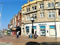
Junction – Westgate and Bridge Street
- There are two crossings at this junction.
- These crossings have dropped kerbs on both sides, but Westgate doesn't have tactile paving on both sides.
- The surface of the pathways is block paving and concrete, and is uneven in places.
- There is a slight uphill slope leading along Bridge Street (left to right as you exit Westgate).
- Photographs 2 and 3 show the crossing over Westgate.
- Photographs 4 and 5 show the crossing over Bridge Street.
Westgate to Potter Street via Bridge Street
- The distance from Westgate to Potter Street is approximately 81m.
- As you exit Westgate there is a slight uphill slope leading along Bridge Street (left to right as you exit Westgate). The slope then becomes a slight downhill slope.
- The pavement is block paving.
- The pathways on both sides are wide but often narrow to less than 120cm on both sides to pass some bollards and signboards.
- There are some obstructions along the pavement on both sides such as trees, signs, cash points, railings, cycle racks, bus stops, bins, and signboards.
- There are some side roads/entrances to cross and these are mainly level with the pathways with some having just dropped kerbs and no tactile paving.
- There are bus stops available on Bridge Street, nearby Westgate, and Market Place.
- There is some seating available near the junction with Westgate and along the route.
- There is some limited on street Blue Badge parking available on Bridge Street outside the Associate Information Centre close to the junction with Westgate.
Junction - Potter Street, Bridge Place, and Bridge Street
- There are two pedestrian crossings at this junction, and one crossing with dropped kerbs and tactile paving.
- The two pedestrian crossings are over Bridge Street and Potter Street.
- All crossings have dropped kerbs and tactile paving on both sides over Bridge Place, Bridge Street, and Potter Street.
- The pedestrian crossings are push button controlled with visual signals. The buttons are 104cm in height.
- The surface of the roads is tarmac.
- The surface of the pathways is block paving and concrete and uneven in places.
- There is a slight uphill slope leading along Bridge Street as you face Bridge Street from Bridge Place and Potter Street.
- There is a slight downhill slope leading along Bridge Place as you face Bridge Street and Potter Street.
- There is a slight downhill slope leading along Potter Street as you face Bridge Street and Bridge Place.
- Photograph 2 shows the crossing over Bridge Place.
- Photographs 3-6 shows the crossing over Bridge Street.
- Photographs 7-10 shows the crossing over Potter Street.
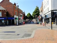
Potter Street to Newcastle Avenue via Bridge Place
- The distance from Potter Street to Newcastle Avenue is approximately 322m.
- As you exit Potter Street there is a slight downhill slope leading along Bridge Place and then becomes level.
- There is a pedestrian only area between Potter Street and Newcastle Avenue.
- There is vehicle access for emergency vehicles, delivery vehicle and authorised vehicles only.
- The pavement is block paving.
- The pathways on both sides are wide but often narrow to pass some bollards and signboards.
- There are some obstructions along the pavement on both sides such as signs, cash points, railings, cycle racks, outside seating areas, street performers, bins, and signboards.
- There are some entrances which have a slight slope downhill towards Bridge Place.
- There are bus stops available on nearby Westgate and Newcastle Avenue.
- There is some seating available at the centre of the pathway along the route.
- There is some limited on street Blue Badge parking available nearby on Bridge Street outside the Associate Information Centre close to the junction with Westgate.
Junction - Bridge Place and Newcastle Avenue
- There are two pedestrian crossings at this junction and two crossings with dropped kerbs and tactile paving.
- The two pedestrian crossings are over Newcastle Avenue.
- All crossings have dropped kerbs and tactile paving on both sides.
- The pedestrian crossings are push button controlled with visual signals. The buttons are 104cm in height.
- The surface of the roads is tarmac.
- The surface of the pathways is block paving and concrete, and is uneven in places.
- The path and road are level in all directions at this junction.
- Photographs 2-4 show the crossing over Bridge Place next to Timpsons.
- Photographs 5-12 show the crossings over Newcastle Avenue.
Newcastle Avenue to Ryton Street via Bridge Place
- The distance from Newcastle Avenue to Ryton Street is approximately 95m.
- This section is mainly level throughout.
- This is a pedestrian only area between Newcastle Avenue to Ryton Street. There is vehicular access for emergency vehicles, delivery vehicles, and authorised vehicles only.
- The pavement is block paving.
- The pathways on both sides are wide but often narrow to pass some bollards, trees, and signboards.
- There are some obstructions along the pavement on both sides such as trees, signs, cash points, railings, cycle racks, outside seating areas, street performers, bins, and signboards.
- There are some entrances which have a slight slope downhill towards Bridge Place.
- There are bus stops available on nearby Newcastle Avenue.
- There is some seating available at the centre of the pathway along the route.
- There is not nearby on street Blue Badge parking available or standard parking but there is a car park at Queen Street approximately 0.2 miles away via Newcastle Avenue.
Junction - Ryton Street and Bridge Place
- There are four pedestrian crossings at this junction over Ryton Street and Bridge Place.
- All crossings have dropped kerbs and tactile paving on both sides.
- The pedestrian crossings are push button controlled with visual signals. The buttons are 104cm in height.
- The surface of the roads is tarmac.
- The surface of the pathways is block paving and concrete and is uneven in places.
- The path and road are level in all directions at this junction.
- Photographs 2 and 3 show the crossings over Bridge Place.
- Photographs 4-8 show the crossings over Ryton Street.
Ryton Street to Watson Road via Bridge Place
- The distance from Newcastle Avenue to Ryton Street is approximately 95m.
- This section is mainly level throughout.
- This is a pedestrian only area between Ryton Street and Priory Shopping area. The area then becomes a pathway either side of the road between Priory Shopping area and Watson Road, with access for emergency vehicles, delivery vehicles, and authorised vehicles in the pedestrian area.
- The pavement is block paving.
- There is a crossing with dropped kerbs and tactile paving on both sides outside Priory Shopping area. Photographs 11 and 12 show this crossing
- The pathways on both sides are wide but often narrow to pass some bollards and signboards.
- There are some obstructions along the pavement on both sides such as trees, signs, cash points, railings, cycle racks, outside seating areas, street performers, bins, and signboards.
- There are some entrances which have a slight slope downhill towards Bridge Place.
- There are bus stops available on nearby Watson Road.
- There is some seating available at the centre of the pathway along the route.
- There is some on street Blue Badge parking available on Bridge Place close to Priory Shopping area, and at the Priory Shopping area car park.
Junction - Watson Road and Bridge Place
- There are three pedestrian crossings at this junction over Watson Road and Bridge Place.
- All crossings have dropped kerbs and tactile paving on both sides.
- The pedestrian crossings are push button controlled with visual signals. The buttons are 104cm in height.
- The surface of the roads is tarmac.
- The surface of the pathways is block paving and concrete and is uneven in places.
- The path and road are level in all directions at this junction.
- Photographs 2-5 show the crossings over Bridge Street.
- Photographs 6-12 show the crossings over Watson Road.
Accessible Toilet
- Accessible toilet facilities are not available.
-
Comments
View
- There are no accessible toilets available directly on the route but there are plenty of nearby restaurants which may allow you to use their facilities.
Standard Toilet(s)
-
Availability and Location of Standard Toilets
View
- Standard toilet facilities are not available.
-
Comments
View
- There are no accessible toilets available directly on the route but there are plenty of nearby restaurants which may allow you to use their facilities.