
Access Guide
Overview
- This Access Guide is about the section of King's Road between Sloane Square in the east and Milman's Street in the west.
This is a distance of about 1.7km (1 mile).
This guide was created in December 2021 and updated April 2023.
The area may have changed since the guide was created. - The area is known for its boutique shops and restaurants.
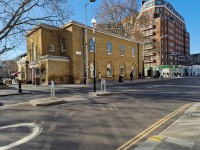
- Pavements are generally wide and level, but can be congested.
King's Road has busy two-way traffic and most people will need to use one of the pedestrian or zebra crossings to cross it.
There are many side roads to cross.
Most are uncontrolled crossings with level or dropped kerbs and tactile paving. - There are some opportunities to sit and rest, but there are long intervals between them.
- The main ways to get to King's Road are by train, tube, bus and taxi.
Sloane Square underground station is about 120m east of King's Road.
The nearest underground station with step-free access is Victoria.
There are bus stops on both sides of King's Road that serve routes connecting with Victoria Station. - There is generally no parking on King's Road.
There are limited pay-by-phone on-street parking bays, including Blue Badge bays, in some side roads. - There is a standard automatic toilet in Sloane Square near to the underground station, but this was out of order at the time of our survey.
- To view the Access Guide for Sloane Square please click here (new tab)..
- To view the Access Guide for Duke of York Square please click here (new tab)..
Getting Here
-
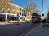
By Bus
View
- There are many bus stops on both sides of Kings' Road.
Bus stops between Sloane Square and Sydney Street serve routes 11, 19, 22, 211, and night buses N11, N19 and N22.
In this area, all stops, except eastbound stop E, also serve route 319.
This route terminates in Sloane Square.
West of Sydney Street, King's Road is served by routes 11 and 22, and night buses N11 and N22.
All London buses have ramped access and dedicated space for wheelchair users. - For more information on London buses (Transport for London) please click here (opens new tab).
- There are many bus stops on both sides of Kings' Road.
-
By Underground
View
- The nearest underground station is Sloane Square, served by the District and Circle lines.
This station does not have step-free access.
The nearest station with step-free access is Victoria (District, Circle and Victoria Lines).
This is about 1.6km (1 mile) from King's Road.
Bus routes 11 and 21 connect Victoria Station with King's Road. - For more information on London Underground services please click here (opens new tab).
- The nearest underground station is Sloane Square, served by the District and Circle lines.
-
By Train
View
- The nearest railway station is London Victoria.
- London Victoria Station has step-free access to all platforms and staff available to assist with ramps between the platform and the train.
- For more information on access and facilities at London Victoria Station please click here (opens new tab).
-
By Road
View
- A3217 - King's Road connects with Sloane Square to the east.
To the west it becomes the A308 New King's Road towards Putney.
King's Road is outside the Central London Congestion Charge Zone.
The area is in the Ultra Low Emission Zone (charges apply at all times for non-compliant vehicles). - For more information on driving in London please click here (opens new tab).
- Parking in the area is very limited and visitors are encouraged to use public transport.
There are standard on-street pay-to-park bays in some of the side roads.
There are 2 on-street Blue Badge bays in Lincoln Street, opposite Duke of York Square, and a single Blue Badge bay in Bywater Street.
There is an underground NCP car park east of Sloane Street in Cadogan Place.
The website mentions that it has Blue Badge bays.
The pedestrian access to/from the car park is very steep.
There is also a car park in Pavilion Road to the west of Sloane Street.
This car park does not have disabled access. - For more information on the Blue Badge scheme and parking in London please click here (opens new tab).
- For more information on disabled parking for visitors in Kensington and Chelsea please click here (opens new tab).
- London Black Cabs can be hailed in any location or summoned by phone.
- A3217 - King's Road connects with Sloane Square to the east.
-
By River
View
- 6 TfL River Bus routes run from 22 piers between Putney and Woolwich.
The nearest accessible pier is Millbank.
This is about 400m from bus routes on Vauxhall Bridge Road that connect with Sloane Square and King's Road.
There is step-free access onto the river buses, except at 3 piers.
Please see the TfL website for details - For more information on London River Bus services please click here (opens new tab).
- 6 TfL River Bus routes run from 22 piers between Putney and Woolwich.
-
By Air
View
- The nearest airports to central London are London City Airport, London Gatwick and London Heathrow.
London City Airport is connected to the centre by the Docklands Light Railway (DLR) to Bank, or Tower Gateway with interchanges to the rail and underground network at Canning Town and Stratford.
From Gatwick Airport there are fast trains connecting to London Bridge Station.
Heathrow Airport is connected by fast trains to Paddington Station and is also on the Piccadilly underground line. - For more information on travelling to London by air please click here (opens new tab).
- The nearest airports to central London are London City Airport, London Gatwick and London Heathrow.
-
Useful Links
View
- Please use the TfL journey planner for details of the most suitable route.
The planner can be filtered by options such as step-free routes or maximum walking distances. - To view the web page described above click here (opens in new tab).
- The TfL website has links to the TfL accessibility guides, including large print maps and audio guides to order or download.
- To view the web page described above click here (opens in new tab).
- Please use the TfL journey planner for details of the most suitable route.
General Accessibility
-
Paths and Pavements
View
- Pavements are generally wide and level but may be congested at busy times .
There are uneven areas around a small number of street trees. - There may be some obstructions from A-board signage outside shops, or tables and chairs on the pavement.
- Many of the shops and businesses have one or more steps at their entrance.
- Pavements are generally wide and level but may be congested at busy times .
-
Street Furniture and Features
View
- Much of the street has black bollards along the edge of the kerb.
There are also some historic white bollards.
Blocks of cycle parking racks are usually near the kerb edge. - The greatest numbers of seats are off King's Road, within Duke of York Square (see related access guide for details).
Also on the south side of King's Road, there are some bench seats at the junction with Royal Avenue.
There are also cycle racks and app-hire cycle and scooter stands here .
There are bench seats near Chelsea Manor Street, outside Chelsea Old Town Hall.
This building has stone steps that project out into the pavement. - On the north side of King's Road, there are bench seats at the junction with Park Walk and outside Chelsea Fire Station at Manresa Road.
There is also a small park at Dovehouse Green .
- Much of the street has black bollards along the edge of the kerb.
-
Maps and Signage
View
- On the south side of King's Road, there are Legible London map signs at Chelsea Manor Street and Old Church Street.
On the north side, there is a map near Markham Square
Some bus shelters also have local maps.
- On the south side of King's Road, there are Legible London map signs at Chelsea Manor Street and Old Church Street.
-
Public Transport
View
- Most of the bus stops have shelters with perching or standard height seats, or a combination of the two
Some of the shelters have bus arrival information displays.
The newest bus stops also have USB charging points next to the seat.
- Most of the bus stops have shelters with perching or standard height seats, or a combination of the two
Main Pedestrian Crossing(s) (Junction with Sydney Street)
- There are 2 crossing points near Sydney Street, one crossing across Sydney Street and another crossing to the opposite side of the King’s Road.
There are push-button controlled pedestrian crossings at all the crossing points.
There are steep pped kerbs with tactile paving at all crossing points but some of the tactile paving is worn. - There are central refuges marked with tactile paving at both crossings of King's Road.
The signals are timed to allow the road to be crossed in one go. - The road surface is grey tarmac.
- There is two-way traffic at all crossing points.
Main Pedestrian Crossing(s) (Junction with Oakley Street)
- There are 3 crossing points near Oakley Street.
There is one crossing across Oakley Street and 2 crossings to the opposite side of King's Road.
There are push-button controlled pedestrian crossings at all 3 crossing points.
There are steep dropped kerbs with tactile paving at all crossing points. - There are central refuges marked with tactile paving at all crossings.
The signals are timed to allow the road to be crossed in one go. - The road surface is grey tarmac.
- There is two-way traffic at all crossing points.
Main Pedestrian Crossing(s) (Junction with Beaufort Street)
- There are 4 crossing points near Beaufort Street.
There are two crossing across Beaufort Street (either side of King’s Road) and 2 crossings to the opposite side of King's Road.
There are dropped kerbs with tactile paving at all the crossing points. - The crossings of King's Road east of Beaufort Street has a staggered refuge and is intended to be crossed in 2 stages.
The crossing of King's Road west of Beaufort Street and the south section of Beaufort Street also have a central refuge, to allow the roads to be crossed in stages.
The refuges have a level surface with crossing points marked by tactile paving. - The road surface is grey tarmac.
- There is two-way traffic in all locations.
Main Pedestrian Crossing(s) (King's Road - Signal-Controlled)
- There are signal controlled crossings to cross King's Road;
- near to the junction with Sloane Square
- near to Flood Street
- near to Old Church Street
All the crossings have dropped kerbs with tactile paving. - The crossing near to Old Church Street has a staggered central refuge so that the road can be crossed in 2 stages.
The refuge has level surfaces with the crossings marked by tactile paving. - The road surface is grey tarmac.
- There is two-way traffic at all crossings.
Main Pedestrian Crossing(s) (Zebra)
- There are zebra crossings to cross King's Road;
- near to Cadogan Gardens
- between Walpole Street and Cheltenham Terrace)
- near to Royal Avenue and Tryon Street
- opposite Markham Square
- near to Radnor Walk and Jubilee Place
- near to Milman's Street and Park Walk
All the crossings have dropped kerbs and tactile paving. - The zebra crossing near to Milman's Street has a central refuge that is marked with tactile paving.
This allows the road to be crossed in 2 stages. - The road surface is grey tarmac and the zebra crossings are clearly marked.
- There is two-way traffic at each crossing.
The zebra crossing near to Royal Avenue has a crossing point for cyclists parallel with the pedestrian crossing.
This allows cyclists to follow a route between Royal Avenue and Tryon Street.
There is tactile paving to warn that cyclists could be crossing the area.
Side Street Crossings (King's Road - North Side)
- The pavement along the north side of King's Road crosses a number of side streets. The type of crossing varies depending on the street.
- There are zebra crossing at Cadogan Gardens and Anderson Street .
There are dropped kerbs with tactile paving.
There is one-way traffic turning from Cadogan Gardens into King's Road.
There is one-way traffic turning into Anderson Street. - When King's Road crosses Blacklands Terrace, Lincoln Terrace, Tryon Street, Bywater Street, Markham Street, Jubilee Street, Burnsall Street, Dovehouse Street, Manresa Road, The Vale and Park Walk, there are crossings where the road is level with the pavement.
There is tactile paving on both sides.
At most of these crossings, the road surface is small paving blocks, to contrast with the tarmac
There are no signals at these crossing to indicate when it is safe to cross, so caution is advised when crossing these side streets.
Some of the side roads, such as Blacklands Terrace, both roads at Markham Square, Jubilee Place, Burnsall Street and Park Walk, have one-way traffic.
Dovehouse Street has one-way vehicle traffic turning into the side road, but cycles are permitted in both directions. - At the crossing over Chelsea Manor Street there are dropped kerbs with tactile paving on both sides.
- When the path crosses Old Church Street and Beaufort Street, there are traffic lights but there are no pedestrian signals.
There is no phase when there could not be vehicles turning north into the road.
Because there are no signals at these crossing to indicate when it is safe to cross, so caution is advised when crossing these side streets.
There are dropped kerbs on both sides of the crossing but on the west side of Old Church Street it is not marked by tactile paving.
. - When the path crosses Sydney Street there is a pedestrian controlled signal crossing.
Side Street Crossings (King's Road - South Side)
- The pavement along the South side of King's Road crosses a number of side streets. The type of crossing varies depending on the street.
- When King's Road crosses Walpole Street , Smith Street , Radnor Walk , Shawfield Steet, Flood Street , Chelsea Manor Street, Glebe Place, Brameton Street, Old Church Street, Paulton Street and Milmans Street, there are crossings where the road is level with the pavement.
There is tactile paving on both sides.
At most of these crossings, the road surface small paving blocks, to contrast with the tarmac
There are no signals at these crossing to indicate when it is safe to cross, so caution is advised when crossing these side streets.
Some of the side roads, such as Brameton Street and Radnor Walk have one-way traffic.
. - At the crossing over Wellington Square there are dropped kerbs with tactile paving on both sides.
There are no signals at this crossing to indicate when it is safe to cross, so caution is advised when crossing these side streets.
. - When the path crosses Beaufort Street, there are traffic lights but there are no pedestrian signals.
There is no phase when there could not be vehicles turning north into the road.
Because there are no signals at these crossing to indicate when it is safe to cross, so caution is advised when crossing these side streets.
There are dropped kerbs on both sides of the crossing.
. - When the path crosses Oakley Street there is a pedestrian controlled signal crossing.