
Access Guide
Route Introduction
- This is a route plan travelling from the end of High Street at the B483 end, to the junction of Windsor Street and Cross Street.
- The route is approximately 0.4 miles.
- The route takes approximately 12 minutes.
- The route is along High Street and down Windsor Street.
- The route is part pedestrianised.
- Potential hazards include narrow and busy paths.
Location
- There is a bus stop within 150m (164yds) of the venue.
- The nearest National Rail station is West Ruislip.
- The nearest underground station is Uxbridge.
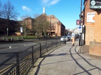
High Street to Vine Street
- This section of the route is from the start of High Street to the junction with Vine Street.
- The path along this section is mostly block paved.
- This section of the route is approximately 0.2 miles.
- The start of this section is a downhill slope.
- Proceed along High Street.
- After approximately 50m you will come to the entrance to a car park.
- There is a dropped kerb.
- The dropped kerb does not have tactile paving.
- Traffic can come from both directions.
- Once across this entrance proceed ahead along High Street for approximately 150m.
- The pathway is wider than 150cm all along this section.
- Once you get to the junction with Vine Street continue ahead into the pedestrianised area.
High Street to Windsor Street
- This section of the route is a pedestrianised area.
- The pavements here are wide.
- The pavement is block paved and slab paved.
- There are some benches along this route.
- The benches do not have armrests.
- This section of the route is approximately 0.1miles.
- Proceed along High Street.
- The High Street can be busy at times.
- There are sometimes cyclists using this area.
- You will come to a left turn into Windsor Street.
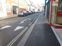
Windsor Street to Cross Street
- Once you have turned left into Windsor Street the pathway narrows to 110cm.
- The pathway varies in width throughout this section.
- Potential hazards include lamp posts built into the pavement, signage on the pathway and loading areas.
- This section of the route is approximately 0.1miles.
- The path is also an easy slope downwards.
- Proceed along Windsor Street.
- The path curves around to the right.
- This area is a loading bay.
- The loading bay has dropped kerbs without tactile paving.
- The loading bay area is now level with both pathways on either side of it.
- The path continues across the loading bay area after the dropped kerb by a tarmac surface straight to the other side of the loading area.
- Proceed ahead and follow Windsor Street around to the left.
- The path here is mainly paving slabs.
- Continue along Windsor Street.
- After approximately 20m you will come to another loading area with dropped kerbs.
- This dropped kerb does not have tactile paving.
- Follow Windsor Street to the junction with Cross Street.