
Access Guide
Route Information
- The following information describes the route from Rotherham Interchange to Clifton Park.
- The approximate distance of this route is 1.9km.
- The route takes approximately 25-35 minutes.
- The route leads across Water Street, up Drummond Way and along Wharncliffe Street to the park.
- The majority of paths along the route are concrete paving or block paving with moderate gradients in places.
- There is public parking located above the Interchange.
- The potential hazards on this route include; busy roads, crossing points and congested pathways.
- The visual indicators at the crossing points are activated by push buttons; these are between the heights of 95cm and 105cm.
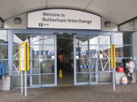
Starting Point Rotherham Interchange East - A10 Entrance
- Accessible toilets are available within the interchange.
- There is step free access along the interchange platforms.
- There is step free access when exiting the interchange.
- Car parking facilities are available with level access via a lift to the interchange.
- For more information about (Rotherham Interchange) please click here(opens in new tab).
Water Street to Drummond Street
- Exit the Interchange East - A10 Stand Entrance and turn right.
- There is a crossing immediately in front of you.
- The crossing point consists of two road crossings, the first is for buses exiting the Interchange and the second is Water Street.
- At both crossing points traffic is coming from your right.
- The crossing points are level with tactile paving.
- Cross both crossings and carry on for 15m until you reach the crossing for Effingham Square.
- The crossing is level and has tactile paving.
- The traffic comes from the left.
- Cross at the crossing onto Effingham Square.
- Turn left and walk forward 15m, this is Drummond Street.
Drummond Street to Wharncliffe Street
- Continue uphill along Drummond Street which bears to the right, past the phone box and bench seating.
- The slope is a moderate gradient.
- After the line of bollards cross Henry Street.
- The crossing is level with tactile paving.
- The traffic comes from both sides.
- Continue up Drummond Street for 25m, past the Indoor Market which will be on the right.
- The gradient of the path becomes steep and the surface is block paving and concrete slabs.
- Cross Eastwood Lane.
- The crossing has tactile paving and dropped kerbs to each side.
- The traffic is coming from the right.
- Once across Eastwood Lane, Drummond Street becomes Wharncliffe Street.
Wharncliffe Street to Percy Street
- Continue up Wharncliffe Street with the College on your right.
- The slope is moderate and the pavement surface changes to tarmac.
- Percy Street is at the top.
- Cross over Percy Street at the crossing.
- The crossing has tactile paving and dropped kerbs.
- The traffic comes from both sides.
Percy Street to Clifton Park
- After crossing Percy Street continue on Wharncliffe Street which starts to descend at a slight gradient.
- Continue past the sign and bus stop for 30m until you reach Doncaster Road.
- At the junction turn left and cross over Wharncliffe Street at the crossing.
- The crossing consists of two pedestrian crossings, with a central island.
- At the first crossing the traffic comes from the right.
- At the second crossing the traffic comes from the left.
- Each crossing point is controlled by a visual indicator.
- The visual indicators are activated by push buttons.
- There are rotating cones located at the base of the push button boxes to indicate when it is safe to cross.
- There are dropped kerbs with tactile paving at each crossing point.
- Once over the crossing, turn right.
- Continue for 8m and cross Doncaster Road at the next pedestrian crossing.
- The crossing point is controlled by a visual indicator.
- The visual indicators are activated by push buttons.
- There are rotating cones located at the base of the push button boxes to indicate when it is safe to cross.
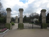
- Once over the crossing there is an easy slope up to Clifton Park gates on the left.