
Access Guide
Overview
- This Access Guide covers the complete length of Sloane Street.
This is a distance of approximately 1km (0.6 miles).
This guide was created in December 2021 and updated in January 2023.
The area may have changed since the guide was created, however for the latest news and updates please click here. - The northern section of Sloane Street, near to Knightsbridge, and the southern section, near to Sloane Square, is known for luxury shops, particularly designer fashion brands.
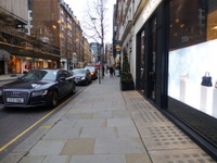
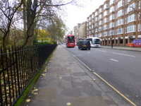
- Pavements are generally wide and level, but can be congested at busy times.
There is busy two-way traffic for the full length of the street.
There are controlled crossing points such as traffic lights and zebra crossings at intervals along the street. - Some of the side roads are also crossed at traffic lights or zebra crossings.
Others are uncontrolled crossings.
Most crossing points have dropped kerbs, but not all have tactile paving. - There are Legible London map signs at intervals along the street.
There is no seating other than those at bus stops. - The main ways to get to Sloane Street are by train, tube, bus and taxi.
Knightsbridge underground station is near the northern end of Sloane Street.
Sloane Square underground station is near the southern end of the street.
The nearest underground stations with step-free access are Green Park and Victoria.
There are bus stops on both sides of Sloane Street. - There are no parking bays on Sloane Street.
There may be limited pay-by-phone on-street parking bays in some side roads.
There are public car parks nearby in Cadogan Place and Pavilion Road. - There are no public toilets in Sloane Street.
. - To view the Access Guide for Sloane Square please click here (new tab)..
- To view the Access Guide for Pavilion Road please click here (new tab)..
- To view the Access Guide for King's Road please click here (new tab)..
Getting Here
-
By Bus
View
- There are three bus stops on each side of Sloane Street.
Bus routes 19, 22, 137, 452 and C1 travel in both directions.
It is also served by night bus routes N19, N22 and N137.
All London buses have ramped access and dedicated space for wheelchair users. - For more information on London buses (Transport for London) please click here (opens new tab).
- There are three bus stops on each side of Sloane Street.
-
By Underground
View
- The nearest stations with step-free access are Green Park (Jubilee, Piccadilly and Victoria Lines) and Victoria (District, Circle and Victoria Lines).
Both stations are over 1km from Sloane Street.
Bus routes 19 and 22 connect Green Park Station with Sloane Street.
The nearest underground stations to Sloane Street are Knightsbridge (Piccadilly Line) and Sloane Square (District and Circle Lines).
These stations do not have step-free access. - For more information on London Underground services please click here (opens new tab).
- The nearest stations with step-free access are Green Park (Jubilee, Piccadilly and Victoria Lines) and Victoria (District, Circle and Victoria Lines).
-
By Train
View
- The nearest railway station is London Victoria.
- London Victoria Station has step-free access to all platforms and staff available to assist with ramps between the platform and the train.
- For more information on access and facilities at London Victoria Station please click here (opens new tab).
-
By Road
View
- Sloane Street (A3216) runs north-south and connects with A3217 - King's Road/Cliveden Place to the south at Sloane Square.
To the north it connects with A4 - Brompton Road/ Knightsbridge.
Sloane Street is just outside the Central London Congestion Charge Zone, which starts nearby on Knightsbridge to the east (charges apply Monday - Friday 07:00 -18:00).
The area is in the Ultra Low Emission Zone (charges apply at all times for non-compliant vehicles). - For more information on driving in London please click here (opens new tab).
- Parking in the area is very limited and visitors are encouraged to use public transport.
There is an underground NCP car park east of Sloane Street in Cadogan Place.
The website mentions that it has Blue Badge bays.
The pedestrian access to/from the car park is very steep.
There is also a car park in Pavilion Road to the west.
This car park does not have disabled access.
There are standard on-street pay-to-park bays in some of the side roads. - For more information on the Blue Badge scheme and parking in London please click here (opens new tab).
- London Black Cabs can be hailed in any location or summoned by phone.
- Sloane Street (A3216) runs north-south and connects with A3217 - King's Road/Cliveden Place to the south at Sloane Square.
-
By River
View
- 6 TfL River Bus routes run from 22 piers between Putney and Woolwich.
The nearest accessible pier is Westminster.
This is close to Westminster Underground Station on the Jubilee Line which connects to Green Park Station.
There is step-free access onto the river buses, except at 3 piers.
Please see the TfL website for details. - For more information on London River Bus services please click here (opens new tab).
- 6 TfL River Bus routes run from 22 piers between Putney and Woolwich.
-
By Air
View
- The nearest airports to central London are London City Airport, London Gatwick and London Heathrow.
London City Airport is connected to the centre by the Docklands Light Railway (DLR) to Bank, or Tower Gateway with interchanges to the rail and underground network at Canning Town and Stratford.
From Gatwick Airport there are fast trains connecting to London Bridge Station.
Heathrow Airport is connected by fast trains to Paddington Station and is also on the Piccadilly underground line. - For more information on travelling to London by air please click here (opens new tab).
- The nearest airports to central London are London City Airport, London Gatwick and London Heathrow.
-
Useful Links
View
- Please use the TfL journey planner for details of the most suitable route.
The planner can be filtered by options such as step-free routes or maximum walking distances. - To view the web page described above click here (opens in new tab).
- The TfL website has links to the TfL accessibility guides, including large print maps and audio guides to order or download.
- To view the web page described above click here (opens in new tab).
- Please use the TfL journey planner for details of the most suitable route.
Major Disruption 2023-2024
- Sloane Street is undergoing major construction / road work projects during 2023 and 2024.
- Visitors ought to expect obstacles and diversions involving surface changes and abrupt kerbs at any time.
- Disruption points are likely to be variable in location according to contractor progress.
- Sloane Street is also likely to be closed to road traffic at any time.
- For more information on Sloane Street’s transformation please click here.
General Accessibility
-
Paths and Pavements
View
- Pavements are generally wide and level (photographs 1 to 4).
- There are a small number of uneven areas where there are dropped kerbs at service vehicle access points across the pavement.
There are also some uneven surfaces where there is bare earth around the base of trees (photographs 5 and 6). - Some of the shops have a row of large planters outside.
A small number have post and rope barriers to manage any queues at their entrances (photographs 7 to 9).
-
Street Furniture and Features
View
- There is no seating in the street, other than at bus stops.
There are a number of waste disposal bins along both sides of the street.
There are potential obstructions from shop/restaurant signage boards. - There are some cycle racks near the edge of the pavement (photograph 10).
There may also be bikes chained to lampposts and street signage posts. - If people visit between late April and September, or November to January, there is likely to be cafés or other events happening on the Square.
For the remaining part of the year the quare will be empty, with just the fountain, war memorial and public seating.
- There is no seating in the street, other than at bus stops.
-
Maps and Signage
View
- There are Legible London map signs near the zebra crossing opposite Harriet Street (west side), and near Pont Street (east side - photographs 11 to 12).
There is also directional signage near to Hans Street (west side).
- There are Legible London map signs near the zebra crossing opposite Harriet Street (west side), and near Pont Street (east side - photographs 11 to 12).
-
Public Transport
View
- There are 3 bus stops on each side of the street.
These are at the south of the street, near Sloane Square, at the northern end, between Harriet Street and Basil Street and centrally near to Pont Street.
All the bus stops have shelters and standard or perching seats (photographs 13 to 15). - The access point to Knightsbridge underground station, near the junction of Sloane Street and Knightsbridge is by steps only (photograph 16).
- There are 3 bus stops on each side of the street.
Main Pedestrian Crossing(s) (Junction with Knightsbridge)
- This crossing is at the junction of Sloane Street with Knightsbridge.
There are dropped kerbs with tactile paving on each side of the road. - There is a central pedestrian refuge with a level surface that is marked by tactile paving.
The crossing is busy and the refuge is often congested. - The road surface is grey tarmac.
- There is two-way traffic.
The traffic direction is shown by painted floor signs.
Main Pedestrian Crossing(s) (Junction with Pont Street)
- These crossings are at the junction of Sloane Street with Pont Street.
There are steep dropped kerbs with tactile paving on each side of the road at all four crossing points. - There is a central pedestrian refuge with a level surface that is marked by tactile paving at each crossing point.
The refuges are very small, meaning that it is safer to cross the road in a single stage. - The road surface is grey tarmac.
- There is two-way traffic.
At some of the crossings, the traffic direction is shown by painted floor signs.
Some crossings have no floor signs or ones that are very worn.
Main Pedestrian Crossing(s) (Sloane Street (pedestrian crossing)
- There is a push-button controlled pedestrian crossing on Sloane Street, near the junction with Basil Street.
There are steep dropped kerbs with tactile paving on both sides of the road. - The road surface is grey tarmac.
- There is two-way traffic.
Main Pedestrian Crossing(s) (Sloane Street (zebra crossings)
- There are four zebra crossings to cross Sloane Street.
These are;
- near to Harriet Street (photographs 1 and 2).
- near the northern junction with Cadogan Place (photographs 3 and 4).
- south of the junction with Cadogan Gate/ Cadogan Place (photographs 5 and 6).
- at the southern end of the street near to Sloane Square (photographs 7 and 8).
There are steep dropped kerbs with tactile paving on each side of the road at all zebra crossings. - There is a central pedestrian refuge at the crossings near to Cadogan Gate/ Cadogan Place, and near Sloane Square.
These have a level surface that is marked by tactile paving.
The refuges allow the road to be crossed in two stages. - The road surface is grey tarmac.
- There is two-way traffic.
At the zebra crossing near to Sloane Square there is painted floor signage to indicate the direction of traffic.
Side Street Crossings
- The crossing with the side street Cadogan Place at its northern end has a zebra crossing (photographs 1 and 2).
There are dropped kerbs with tactile paving on both sides of the road.
On the south side the dropped kerb is steep. - On the east side of Sloane Street, there are dropped kerbs with tactile paving at the junctions with Harriet Street (photographs 3 and 4) and the southern section of Cadogan Place (photographs 5 and 6).
Some of the tactile paving is very worn. - Also on the east side, there are dropped kerbs with no tactile paving at the junctions with Ellis Street, Wilbraham Place and Sloane Terrace (photographs 7 and 8).
Some of the dropped kerbs are uneven. - On the west side of Sloane Street, there is a pedestrian crossing at the junction with Basil Street (photograph 9).
The crossing has dropped kerbs with tactile paving.
Basil Street was closed to traffic at the time of the survey. - At the junction with Hans Street, there are dropped kerbs with no tactile paving (photograph 10).
- At the junction with Pavilion Street, the crossing is level with tactile paving on both sides (photographs 11).
The Pavilion Street crossing surface is multi-coloured block paving. - Also on the west side, there are dropped kerbs with tactile paving at the junctions with Cadogan Gate (photographs 12 and 13) and Cadogan Gardens (photographs 14 and 15).