
Access Guide
Introduction
- The route is approximately 1.8 miles long.
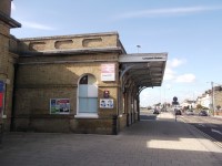
Continue ahead from Lowestoft Train Station to Station Square
- On exiting the train station turn right and continue ahead.
- The surface of the pathway is block paving.
- It is uneven in places.
- The pathway turns to the right and the crossing over Denmark Road is located in front of you.
- The push button is 105cm high.
- There are areas of tactile paving on both sides of the crossing.
- The surface of the crossing is tarmac.
- After the crossing turn right and continue ahead.
- The surface of the path is block paving.
- It is uneven in places.
- Continue ahead to the Waveney Road crossing.
- The push button is 105cm high.
- There are areas of tactile paving on both sides of the crossing.
- The surface of the crossing is tarmac.
- After the crossing turn right on Station Square and continue ahead towards the Inner Harbour Bridge.
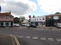
Continue ahead on Station Square
- Continue ahead on Station Square.
- The surface of the pathway is smooth tarmac.
- It is uneven in places.
- The pathway is on a moderate slope leading up to the bridge.
- The surface of the pathway becomes more uneven as you approach the bridge.
Cross Inner Harbour Bridge
- There is an area of the tactile paving at each side of the bridge.
- There is also a gate at each side of the bridge on the pathway.
- These gates are closed when the bridge is raised for river traffic.
- The surface of the bridge is smooth tarmac.
- There is a lip at the centre of the bridge where the sections of the bridge join together.
- Traffic crossing the bridge causes the surface to move up and down.
- At the far side of the bridge the surface becomes uneven tarmac.
- Continue ahead.
Follow the pathway towards South Pier
- The surface of the pathway changes from rough tarmac to block paving.
- It is uneven in places.
- Continue along the pathway passing the Harbour Inn which is located to your right.
- Then turn left towards South Pier.
- There are bollards located on the pathway.
- The surface changes to small block paving after going through the bollards.
- Continue ahead towards the South Pier.
Turn right towards the Sea Front Pathway
- The pathway now crosses a pedestrian area.
- The surface of the pathway is block paving.
- It is uneven in places.
- The are bollards in front of you as you enter the pedestrian area.
- Continue ahead passing with the water fountains located on your right.
- This area of the pathway is on an easy slope leading to the sea front pathway.
- As you join the Sea Front pathway the surface becomes tarmac.
Continue on Seafront Pathway
- The surface of the pathway is rough tarmac.
- It is uneven in places.
- Seating is available at regular intervals along the pathway.
- A cycle lane in located on the pathway.
- The Aquarium is located on the left at the base of a section of the pathway that is on a steep, long slope leading upwards.
- At the top of the slope the Cefas Laboratory is located on the right.
- At this point the pathway narrows to 140cm.
- The surface of the pathway is smooth tarmac.
- The pathway now turns to the right.
- At the end of this section the surface changes to block paving before becoming smooth tarmac again.
- Continue ahead towards Pakefield Road.
- As you approach the road the pathway is on a steep downward slope.
Turn left onto Pakefield Road
- The surface of the pathway is smooth tarmac.
- It is uneven in places.
- A car park is located to the left and there is dropped kerbs at the entrance and exit point.
- At the crossing of Pakefield Road there is dropped kerbs on both sides with tactile paving on the near side.
- The surface of the crossing is tarmac.
- On the far side of the crossing turn right on to the pathway.
Turn right onto pathway towards Pakefield Street
- Keep to the right of the pathway.
- The left side of the pathway is a designated cycle path.
- The surface of the pathway is rough tarmac.
- It is uneven in places.
- To reach Pakefield Street you must cross the pathway and for a short distance use the cycle path.
- There are dropped kerbs without tactile paving on both sides of the pathway.
Continue on Pakefield Street
- The surface of the pathway is rough tarmac.
- Continue ahead before crossing Pakefield Street as you reach the public car park.
- There are 3 Blue Badge bays located within the car park.
- There are dropped kerbs without tactile paving on both sides of the road.
- After crossing, continue ahead.
- The surface of the pathway is rough tarmac.
- It is uneven in places.
- There are a series of drainage gullies and dropped kerbs on the pathway.
- The Trowel and Hammer public house is located on the left.
- Ahead, cross the All Saints Road.
- There are dropped kerbs on both sides of the crossing with tactile paving only on the far side.
- Ahead cross Dolphin Close.
- There are dropped kerbs without tactile paving on both sides of the crossing.
- The centre of Pakefield is located ahead.
Pakefield Street Toilet Facilities
- There are accessible and standard toilet facilities located to the right.
- The standard toilets have a single medium step at the entrance.
- There are single doors to the enter the male and female standard toilet.
- The door opens away from you and is 70cm wide.
- The accessible toilet can be accessed via radar key.
Pakefield Centre
- There are crossings located ahead and to the left.
- They have dropped kerbs with tactile paving on both sides and traffic island in the middle of the road.
- Bus routes are available between Pakefield and Lowestoft Train Station.
- These services are the 99, 103 and X2 and run at regular intervals throughout the day.