
Access Guide
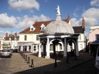
from Bungay Buttercross cross St Mary's Street
- The surface of the pathway is block paving.
- It is uneven in places.
- Ahead, cross St Mary's Street.
- There are dropped kerbs with tactile paving on both sides of the crossing.
- The surface of the crossing is tarmac.
Continue on Earsham Street
- The surface of the pathway is tarmac with cobbled areas.
- It is uneven in places.
- The pathway is on a easy incline towards The Castle Inn.
- There are drainage gullies located on the pathway.
Turn left at the Castle Inn
- As you turn left into the Castle Inn car park the surface becomes rough tarmac.
- It is very uneven in places.
- The pathway is on a steep incline as you approach the gates.
- The gate openings are 120cm and 80cm at the first set and 87cm and 92 at the second set.
Continue on Castle Orchard
- The surface of the pathway is tarmac.
- It is uneven in places.
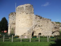
- After passing Bungay Castle ruins the visitor centre entrance is located on the left.
- Turn right at the junction and then left at the next junction staying on Castle Orchard.
- This section of the route does not have a designated pathway.
- At the end of Castle Orchard the entrance to castle hills is located on the left.
- The gate is heavy, opens away from you and is 110cm wide.
Continue on Priory Lane
- The surface of the pathway is tarmac.
- It is uneven in places.
- This section of the route does not have a designated pathway.
- Near the end of Priory Lane there is a dropped kerb onto a pathway.
- The surface of the pathway is tarmac.
- It is uneven in places.
Turn right onto Upper Olland Street
- Cross over Priory Lane.
- There is tactile paving on the near side of the crossing.
- The surface of the crossing is tarmac.
- After the crossing the surface of the pathway is block paving.
- It is uneven in places.
- There are drainage gullies located on the pathway.
- Ahead, cross Quaves Lane.
- There are dropped kerbs with tactile paving on both sides.
- The surface after the crossing is tarmac.
- It is uneven in places.
- Ahead, cross Rose Lane.
- There are dropped kerbs without tactile paving on both sides.
- The surface of the crossing is tarmac.
- Located ahead to the right of the pathway is the Emmanuel Church.
- Double back and towards the Rose Lane crossing.
Turn right onto Turnstile Lane
- There are dropped kerbs without tactile paving on both sides of the road.
- There is a moderate slope immediately after the crossing.
- The surface of the pathway is tarmac.
- It is uneven in places.
- There is an opening at the end of the pathway.
- It is 77cm wide.
Turn left on to Lower Olland Road then continue on St Mary's Street
- The surface of the pathway is tarmac.
- It is uneven in places.
- Ahead, cross Lower Olland Street.
- There are dropped kerbs with tactile paving on both sides of the crossing.
- The surface of the crossing is tarmac.
- After the crossing turn left and continue.
- The surface of the pathway is now block paving with small cobbled areas.
- There is a strip of tactile paving that runs along the edge of the pathway.
- Ahead, cross Cross Street.
- There is tactile paving on the near side.
- The surface of the crossing is tarmac with a cobbled area to the right.