
Access Guide
Introduction
- The route is from the Edinburgh College of Art Square to Potterrow. The distance between these areas is approximately 665m. The route should take around 12 minutes to complete. Bristo Square was being redeveloped at time of survey. Along the route you will need to overcome block paving, tactile block paved, concrete and tarmac surfaces. There are easy to steep gradients along the route. Though after reaching Lauriston Place this route is mostly level. When crossing Forrest Road and Lauriston Place there is busy traffic. Pathways may be congested. There are numerous crossing points along the route.
- Related link ECA Main Building.
- Http://www.disabledgo.com/access-guide/the-university-of-edinburgh/eca-main-building
- Related link ECA Hunter Building.
- Http://www.disabledgo.com/access-guide/the-university-of-edinburgh/eca-hunter-building
- Related link North-East Studio Building.
- Http://www.disabledgo.com/access-guide/the-university-of-edinburgh/north-east-studio-building
Edinburgh College of Art Square to Lauriston Place
- The surface of the square is block paving with a small cobbled area.
- There is a steep slope after this which consists of tactile block paving.
- There is then a slight uphill incline followed by a steep slope down to Lauriston Place.
- There are bollards at the bottom of the ramp with a width of 124cm between them.
Lauriston Place to Keir Street
- The distance to Keir Street is approximately 65m in total.
- The surface of the road is block paving with the occasional manhole cover.
- There is a slight gradient towards the road.
- After approximately 30m there is a tarmac entrance road into the Hunter Building Car Park 5m in width. This can be seen in photograph 2.
- This is a small car park and therefore traffic into it is limited.
- There are tactile drop kerbs on either side. This can be seen in photographs 2 & 3.
- After 3m there is tactile paving for a crossing over Lauriston Place. This can be seen in photograph 4.
- Head over this and continue to the pedestrian crossing across Keir Street approximately 30m away.
Cross Keir Street
- Cross Keir Street to continue along Lauriston Place
- The crossing is place 4m into Keir Street.
- There are tactile drop kerbs on either side of the crossing.
- The surface of the road is tarmac.
- There is a slope immediately your right for 4m to rejoin Lauriston Place.
- The surface of the pavement is block paving and cobbled with the occasional manhole cover.
Lauriston Place to Lauriston Place (George Heriot School)
- Continue along Lauriston Place for approximately 240m.
- There is tactile paving as part of the crossing across Lauriston Place.
- The surface of the pavement is block paving with manhole covers.
- There is a road across Heriot Place after approximately 135m.
- Cross the tarmac road across Heriot Place. There are tactile drop kerbs on either side. This can be seen in photographs 3 & 4.
- Then continue along Lauriston Place for approximately 80m until you reach George Heriot School.
Lauriston Place (George Heriot School) to Forrest Road
- Continue along Lauriston Place for 160m.
- There is a service road for the George Heriot School. This is level with the pavement and is cobbled.
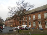
- There is also a slight uphill gradient towards the school (as shown in photograph 1).
- Continue along Lauriston Place. The surface of the road is block pavement with manhole covers.
- There is tactile paving at a pedestrian crossing across Lauriston Place. This can be seen in photograph 3.
- After 150m you will enter Forrest Road which will begin to curve to the left. This can be seen in photograph 5.
- When you reach this area, head immediately to the pedestrian crossing to your right. This can be seen in photograph 6.
Cross Forrest Road and Lauriston Place
- Cross both Forrest Road and Lauriston Place. The distance is 15m.
- There is a pedestrian crossing with traffic lights across Forrest Road leading to a central island which is between Forrest Road and Lauriston Place.
- The pedestrian crossing has tactile drop kerbs on either side.
- The surface of the road is tarmac.
- Traffic along the road is often very busy with traffic approaching from the right.
- The surface of the paving on the island is block paving.
- There is then a similar road between the central island and Lauriston Place.
- This road is also often very busy.
- Here traffic approaches from the left.
Lauriston Place/Teviot Place/Bristo Place to Potterrow
- Turn left upon crossing Lauriston Place until your reach Potterrow. This distance is approximately 200m.
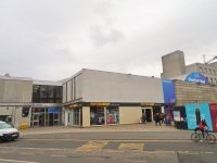
- The surface of the road is block pavement with the occasional manhole cover. This area can be seen in photographs 1 & 2.
- After 24m Lauriston Place becomes Teviot Place.
- There is a cobbled service road 30m after entering Teviot Place leading into the Medical School.
- This is level with the pavement and has tactile paving either side and can be seen in photograph 3.
- As you continue onwards the pavement becomes concrete and there is a slight dip when you encounter the service road into Bristo Place. This is located after approximately 105m from entering Teviot Place and can be seen in photograph 4.
- When you reach Bristo Place and continue along the pavement there is a pedestrian crossing with tactile paving. This can be seen in photograph 6.
- Continue and in front of you is the Potterrow Student's Union building.
- There is a slight incline on approach and a brief line of cobbled paving before there is a return to block paving. This can be seen in photograph 8.