
Access Guide
Introduction
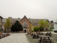
- The route described is between the Holyrood Quad and George Square a distance of 0.8 miles. This route should take approximately 16 minutes to complete. The route takes you past many university buildings including Old College and Potterrow. You will need to overcome, cobbled, brick block paved, block paved, tactile block paved and tarmac surfaces along this route. There are slopes along the route with widths ranging from easy to steep.
- Related link Potterrow - Chaplaincy.
- Http://www.disabledgo.com/access-guide/the-university-of-edinburgh/potterrow---chaplaincy
- Related link Potterrow.
- Http://www.disabledgo.com/access-guide/the-university-of-edinburgh/potterow
Exit Paterson's Land Quad onto St John's Street
- The surface of the Quad is block paving.
- There is an easy slope going up towards the road.
St John's Street to Holyrood Road
- Turn left for approximately 100m until you reach Holyrood Road.
- The surface of the pavement is concrete with the occasional manhole cover.
- There is an easy gradient going down towards Holyrood Road.
- The pavement also has a slight gradient heading down towards the road.
- There were roadworks at the time of survey along this road.
Cross St John's Street
- Turn right upon reaching Holyrood Road and cross St John's Street.
- There is tactile block paving on either side of St John's Street.
- The crossing is at the same level as the pavement.
- The surface of the road is block paving with manhole covers in the middle of the road.
Holyrood Road to Pleasance
- After crossing St John's Street head up Holyrood Road for approximately 200m.
- There is an easy gradient along the road to reach Pleasance.
- The surface of the road is block paving. Though there are some cobbled patches to the right of the street but these can be easily ignored.
- As you continue, there is a section of tactile paving for a crossing across Holyrood Road (as can be seen in photograph 3). Travel over it and continue along Holyrood Road.
- Once you have passed the Outreach Centre the width of the pavement diminishes to only 115cm as can be seen in photograph 6.
- There are then two service roads. One into the Holyrood North Residences and one into Gullan's Close.
- The first consists of brick block pavement (which can be seen in photograph 7) and the latter is cobbled. These are level with the rest of the pavement.
- After this there is a small slope of tactile paving with a manhole cover in the centre after the second service road. This can be seen in photograph 8.
- There is a barrel outside Holyrood 9a which reduces the width of the pavement to 110cm. This can be seen in photograph 9.
- Continue until you reach the pedestrian crossing.
Cross Holyrood Road and Pleasance
- Cross Holyrood Road to reach a central island then turn right and cross the road to reach Pleasance.
- On approaching the crossing, there is a traffic light pole in the pavement providing a width of 95cm (as shown in photograph 1).
- There is then a steep tactile paved drop kerb onto Holyrood Road which has a tarmac surface. This can also be seen in photograph 1.
- This part of the crossing was closed due to roadworks at the time of survey.
- The central island has a tactile kerb which is level with the road.
- There is then a central island the surface of which is tactile block paving (which can be seen in photograph 2).
- Once here, turn right and use the pedestrian crossing to reach Pleasance.
- The tarmac of the road crossing to reach Pleasance is level with the island. However, as you cross the road there is a slight slope to reach Pleasance where there is a tactile drop kerb. This can be seen in photographs 3 & 4.
Pleasance to Drummond Street
- Turn upon crossing Pleasance and continue up the road until you reach Drummond Street.
- The distance is approximately 105m. The hill here is steep.
- The surface of the pavement is block paving with the occasional manhole cover.
- Just before you reach Drummond Street the surface of the road becomes tarmac (as shown in photograph 5).
Drummond Street to South Bridge
- Head up Drummond Street until you reach South Bridge; a distance of approximately 250m.
- Turn right so you head up Drummond Street next to the Flodden Wall.
- As you turn right the right the surface of the pavement is block paving (as can be seen in photograph 1).
- You will then need to turn left where the surface of the road becomes concrete for approximately 5m with manhole covers (as shown in photograph 2).
- After this, the surface of the road is concrete with the occasional manhole cover. There is a steep slope up the hill (as seen in photograph 3).
- There is a service road into the School of GeoSciences Institute of Geography. The surface of the road is cobbled with manhole covers. There are drop kerbs on either side (as seen in photograph 4).
- After the service road there is a portion of the pavement which is uneven block paving for about 10m.
- The surface of the pavement then returns to being concrete.
- As you continue there is a service road which you will need to proceed over. It has a slope downwards towards Drummond Street but is otherwise level with the pavement (as can be see in photograph 6).
- As you do so, the gradient over the pavement changes so there is only a gentle downhill slope.
- As you approach the end of Drummond Street the surface of the pavement becomes block paving with the occasional manhole cover (as seen in photograph 8).
South Bridge
- Turn right and head down South Bridge for 65m until you reach the pedestrian crossing across South Bridge.
- There is tactile paving to the left of the pavement as you turn right for a crossing across Drummond Street. Ignore this and turn right. The paving to your left can be seen in photograph 1.
- The south of the road is block paving with the occasional manhole cover.
- There is a moderate slope towards the lights.
South Bridge to South College Street
- Cross South Bridge at the pedestrian crossing and then turn left for approximately 66m until you reach South College Street.
- There are traffic lights located here.
- There are tactile drop kerbs on either side of the road.
- The surface of the road is tarmac.
- South Bridge is a busy road with plenty of traffic.
- Turn left up South Bridge for approximately 66m.
- There is a slight uphill gradient up the pavement.
- There is a service road into Old College which leads to three of its entrances via either ramps and slopes including steep slope or a steep slope and steps.
- The surface of the road is cobbled.
- There is a 4cm incline on the other side of the surface road to get back on the pavement.
- Then continue on till South College Street.
South College Street to West College Street
- Turn right ignoring the tactile drop kerb across South College Street to West College Street. The distance is approximately 120m.
- Head up South College Street. There is a gradient going up.
- The surface of the pavement is block pavement.
- At the end of South College Street is a tactile drop kerb to cross West College Street. The surface of the street is cobbled and there is a drop kerb on the other side.
West College Street to Potterrow Port
- Turn left on West College street for 26m and head under Potterrow Port.
- The surface of the road to reach the Potterrow Port tunnel is a mixture of block paving, tarmac and cobbled surfaces with the occasional manhole cover.
- There is a slight uphill gradient located here.
- The surface of the Potterrow Port is block paving.
- There is an easy downhill gradient along the Potterrow Port.
Potterrow Port to Bristo Place
- Turn right and head up the ramp to Bristo Place
- The surface of the ramp is block paving.
- There is a handrail in the centre of the ramp.
- The width of the ramp is 110cm.
- The ramp is steep.
- Photograph 2 shows the view at the top of the slope.
Bristo Place/Charles Street to George Square
- Head through Bristo Place past Potterrow and then along Charles Street to reach George Square. This distance is approximately 200m.
- Potterrow is located to your left at the top of the ramp exiting Potterrow Port. The distance to reach the nearest entrance is approximately 10m. This can be seen in photograph 1.
- The surface of Bristo Place is block pavement with the occasional section of brick block paving as shown in photograph 2.
- There is a slight uphill gradient towards Bristo Place until you pass the Potter Shop when this becomes a slight downhill gradient.
- The surface of Bristo Place is primarily block paving.
- After approximately 80m of travelling down Bristo Place it becomes Charles Street.
- After that, the pavement is block paving with the occasional manhole cover and drain.
- As you continue on, stay close to the buildings on your left to avoid any potential traffic, heading down Charles Street.
- There is a bin in the front of the Edinburgh University Visitor Centre. The width of the pavement to the left is 110cm and to the right it's 90cm. This can be seen in photograph 4.