
Access Guide
Introduction
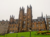
- The distance from the New College to George Square is 0.6 miles. The route should take approximately 13 minutes to complete. The route surfaces include block paving, brick block paving, tactile paving, cobbled and tarmac roads. There are gradients along the route ranging from easy to steep.
- Related link New College School of Divinity.
- Http://www.disabledgo.com/access-guide/the-university-of-edinburgh/new-college-school-of-divinity
- Related link Potterrow.
- Http://www.disabledgo.com/access-guide/the-university-of-edinburgh/potterow
New College to North Bank Street
- Upon exiting the New College onto the Mound, turn right and continue along the pavement for approximately 28m to North Bank Street.
- The surface of the pavement is block paving with the occasional manhole cover.
North Bank Street to Bank Street
- Continue along North Bank Street for approximately 135m to reach Bank Street
- There is a slight downhill gradient until you reach the corner of the building.
- Here you will need to turn right and then there is an uphill gradient.
- Continue until you reach the steps to Milnes Court at which point turn left and continue along the pavement. When you find Lady Stair Close to your right, you will notice a steep slope in front of you.
- You will need to head up the steep slope in order to avoid the alternate stepped routes to The Royal Mile.
Bank Street to Lawnmarket
- Turn Right for 60m until you reach Lawnmarket. The surface of the pavement is block paving with the occasional manhole cover.
- There is a steep uphill gradient along the pavement to reach Lawnmarket.
- Once you reach Lawnmarket head to the pedestrian crossing to your right and use it to cross Lawnmarket. This can be seen in photographs 3, 4, 5 and 6.
- There are traffic lights at the pedestrian crossing.
- There are tactile drop kerbs on either side of the road.
- The surface of the road is cobbled.
- Lawnmarket is a busy road and has traffic approaching in both directions.
King George IV Bridge to Victoria Street
- After crossing Lawnmarket turn left to reach King George IV Bridge and then turn right and head along it for 80m until you reach Victoria Street.
- The surface of the pavement is block pavement with the occasional manhole cover.
- There is an easy downhill slope all the way to Victoria Street.
Cross Victoria Street
- There are tactile drop kerbs on either side of Victoria Street.
- The surface of the road is tarmac.
George IV Bridge to Candlemaker Row
- Continue for 200m down George IV Bridge until you reach Candlemaker Row.
- The surface of the pavement is block paving with the occasional manhole cover.
- There is a slight downhill gradient.
- To the left of the road there are bollards.
- To the left of the road there are also steep drop kerbs to cross George IV Bridge, however these can easily be bypassed by travelling to the right of them.
Candlemaker Row - Forrest Road
- Cross Candlemaker Row Forrest Road
- There are drop kerbs on either side of the road.
- The road itself is tarmac.
- The crossing and road can be seen in photographs 1, 2 & 3.
- After crossing Candlemaker Row, continue along George IV Bridge before turning right into Forrest Road.
- The surface of the pavement is block paving with the occasional manhole cover (which can be seen in photograph 4).
- There is an uphill gradient.
Forrest Road
- Turn right into Forrest Road and continue for 135m.
- The surface of the pavement is block paving.
- There is tactile paving for a pedestrian crossing as you turn right in to Forrest Road (which can be seen in photograph 1).
- There is a slight uphill gradient.
- There is a tarmac service road which is level with the pavement. It leads into 5 Forrest Road after approximately 65m. This can be seen in photograph 4.
- Continue on until you reach the pedestrian crossing that leads across both Forrest Road and Lauriston Place.
Cross Forrest Road and Lauriston Place
- Cross both Forrest Road and Lauriston Place. The distance is 15m.
- There is a pedestrian crossing with traffic lights across Forrest Road leading to a central island which is between Forrest Road and Lauriston Place.
- The pedestrian crossing has tactile drop kerbs on either side.
- The surface of the road is tarmac.
- Traffic along the road is often very busy with traffic approaching from the right.
- The surface of the paving on the island is block paving.
- There is then a similar road between the central island and Lauriston Place.
- This road is also often very busy.
- Here traffic approaches from the left.
Lauriston Place/Teviot Place/Bristo Place to Potterrow
- Turn left upon crossing Lauriston Place until your reach Potterrow. This distance is approximately 200m.
- The surface of the road is block pavement with the occasional manhole cover. This area can be seen in photographs 1 & 2.
- After 24m Lauriston Place becomes Teviot Place.
- There is a cobbled service road 30m after entering Teviot Place leading into the Medical School.
- This is level with the pavement and has tactile paving either side and can be seen in photograph 3.
- As you continue onwards the pavement becomes concrete and there is a slight dip when you encounter the service road into Bristo Place. This is located after approximately 105m from entering Teviot Place and can be seen in photograph 4.
- When you reach Bristo Place and continue along the pavement there is a pedestrian crossing with tactile paving. This can be seen in photograph 6.
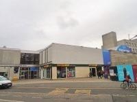
- Continue and in front of you is the Potterrow Student's Union building.
- There is a slight incline on approach and a brief line of cobbled paving before there is a return to block paving. This can be seen in photograph 8.
Bristo Place/Charles Street to George Square
- Head through Bristo Place past Potterrow and then along Charles Street to reach George Square. This distance is approximately 200m.
- Potterrow is located to your left at the top of the ramp exiting Potterrow Port. The distance to reach the nearest entrance is approximately 10m. This can be seen in photograph 1.
- The surface of Bristo Place is block pavement with the occasional section of brick block paving as shown in photograph 2.
- There is a slight uphill gradient towards Bristo Place until you pass the Potter Shop when this becomes a slight downhill gradient.
- The surface of Bristo Place is primarily block paving.
- After approximately 80m of travelling down Bristo Place it becomes Charles Street.
- After that, the pavement is block paving with the occasional manhole cover and drain.
- As you continue on, stay close to the buildings on your left to avoid any potential traffic, heading down Charles Street.
- There is a bin in the front of the Edinburgh University Visitor Centre. The width of the pavement to the left is 110cm and to the right it's 90cm. This can be seen in photograph 4.