
Access Guide
Route Information
- This route goes from the Pollock Halls of Residence on Holyrood Park Road to Peffermill Playing Fields on Peffermill Road.
- The route is 1.1 miles and uses public transport.
- This route will take approximately 12 minutes.
- The route is not a loop, but it can be taken in reverse using the same public transport options.
- The route covers Holyrood Park Road, Dalkeith Road, Prestonfield Avenue and Peffermill Road.
- The surfaces of the route are tarmac and paving slabs.
- There is not street signage directing you along the route, however all streets have street name signage.
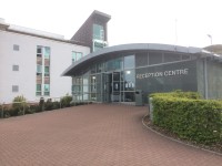
Pollock Halls of Residence
- There is step free access to the Reception Centre, and the concourse in front of it, from all Halls of Residence at Pollock Halls.
- Accessible toilets are available in the Reception Centre.
- There is step free access to exit the Reception Centre.
- Car Parking facilities are available throughout the Halls of Residence.
- For more information about Pollock Halls Reception Centre please click here (opens in new tab).
Pollock Halls of Residence to Royal Commonwealth Pool Bus Stop
- From the Pollock Halls of Residence reception building turn towards the site entrance.
- There is a clearly marked crossing leading from the reception building and Chancellors Court to the site entrance (as shown in photograph 2).
- The crossing has dropped kerbs with tactile paving which can be seen in photograph 3.
- The route is block paved throughout the Pollock Halls site.
- At Holyrood Park Road turn left and cross over the site entrance (as shown in photograph 5).
- There is a designated crossing point.
- The crossing point has dropped kerbs with tactile paving (as shown in photograph 6).
- Traffic is light and passes in both directions at this crossing.
- Continue along Holyrood Park Road.
- There is an easy gradient slope upwards at this point on the route.
- The footpath is paved.
- After approximately 85m cross over the entrance to the Royal Commonwealth Pool car park (as shown in photograph 6).
- There is a designated crossing point with dropped kerb and tactile paving (as shown in photograph 7).
- Traffic is light and passes in both directions at this crossing.
- Continue along Holyrood Park Road to the end of the road.
- There is an easy slope downwards at this point of the route.
- The footpath becomes wider at the junction of Holyrood Park Road and Dalkeith Road (as shown in photograph 9).
- Turn left at the junction and continue along the footpath (as shown in photograph 10).
- The bus stop is ahead towards the far end of the Royal Commonwealth Pool, approximately 113m from the junction (as shown in photograph 12).
- Take the number 2, 14, or 30 bus.
- For more information about the number 2 bus route please click here (opens new window)
- For more information about the number 14 bus route please click here (opens new window)
- For more information about the number 30 bus route please click here (opens new window).
Prestonfield Park Bus Stop to Peffermill Playing Fields
- Remain on the bus for 5 stops.
- This bus journey should take approximately 6 minutes.
- Alight at the 6th stop, get off at the Prestonfield Park Bus Stop (as shown in photograph 1).
- The bus stops opposite Prestonfield Park and Cameron House Community Education Centre.
- This section of the route is approximately 270m.
- Turn right and follow the footpath for 100m to the junction with Prestonfield Road (as shown in photograph 2.
- The footpath is tarmac.
- Cross over the junction (as shown in photograph 3).
- The crossing is not marked.
- There is not a dropped kerb.
- Traffic is light and passes in both directions at this crossing.
- Turn right and cross over Prestonfield Avenue, heading towards Clearburn Road (as shown in photograph 4).
- The crossing is marked and has a dropped kerb with tactile paving (as shown in photograph 5).
- Traffic passes in both directions at this crossing.
- Buses, taxis and cycles are the only traffic allowed on this section of the road and traffic is light.
- The footpath becomes uneven and there is an easy slope downwards after the crossing point.
- Turn left past the post box and continue to the end of Prestonfield Avenue (as shown in photograph 6).
- At the end of the road turn right onto Peffermill Road (as shown in photograph 7).
- After approximately 16m cross the road (as shown in photograph 8).
- There is a marked crossing point (as shown in photograph 9).
- The crossing point has dropped kerbs with tactile paving (as shown in photograph 10).
- There is an island in the middle of the road at the crossing point.
- Traffic is busy and passes from the right at the first half of the crossing.
- Traffic passes from the left at the second half of the crossing.
- After crossing the road continue to the right for approximately 35m (as shown in photograph 11).
- The gates to Peffermill Playing Fields are at the first turning to the left (as shown in photographs 12 and 13).
- Once inside the gates follow the signage to your destination (as shown in photograph 14).
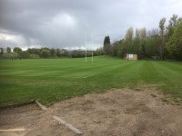
Peffermill Playing Fields
- There is step free access throughout the playing fields.
- Clear directional signage is provided near the entrance.
- There are a variety of sports pitches throughout the playing fields.
- There are changing rooms and a pavilion in the playing fields.
- There is parking as you enter the site from the main road.
- For more information about Peffermill Playing Fields please click here (opens in new tab).