
Access Guide
Introduction
- Related link Kilmarnock Town Centre.
- Https://www.east-ayrshire.gov.uk/BusinessAndTrade/TownCentreManagement/KilmarnockTownCentre.aspx
- Related link Public Car Parks and Tariffs - Ayrshire Roads Alliance.
- Https://www.ayrshireroadsalliance.org/Parking/Where-to-park/Off-street-parking.aspx
- Related link King Street Guide.
- Https://www.accessable.co.uk/east-ayrshire-council/access-guides/king-street-guide
-
Comments
View
- Kilmarnock is a large town in East Ayrshire, located to the west of the A77.
- This guide covers the popular shopping area along Bank Street.
- Bank Street runs from the junction with John Dickie Street near The Cross to the north east until John Finnie Street in the south west.
- It is approximately 260m (0.16miles) and takes around 5 minutes to walk.
- The shopping area is generally level or with slight slopes.
- Footpaths on both sides are of concrete paving slabs.
- The paved areas on each side are around 200cm wide.
- The south side of the street has the least crossings and dropped kerb areas.
- The one-way central road surface is lightly cobbled block paving.
- The central cobbled area is around 600cm wide, with several paved crossing areas.
- There are no opportunities to sit and rest, although there are benches in front of New Laigh Kirk at the Johnnie Walker Statue and The Cross nearby offers some more.
Getting Here
- Parking:
- There are short and long stay car parks in the town centre and some on-street parking located in Bank Street.
- By Bus:
- The bus station around 100m from The Cross from The Foregate, is served by many routes to surrounding areas.
- By Train:
- Kilmarnock Station is approximately 450m (0.28 miles) from The Cross, a 5 minute walk along West George Street and Portland Street.
- Alternatively, using John Finnie Street it is around 600m (0.37 miles) to the south-west end of Bank Street.
- There is a steep slope or steps to the station.
- There are steps to platform 4 (southbound).
- There is a taxi rank outside the station.
Parking
- On-Street Blue Badge Parking
- There are 3 Blue Badge bays on John Dickie Street.
- The John Dickie Street Blue Badge bays are 75-90m from Bank Street.
- There are 3 further on-street Blue Badge bays in James Shaw Lane near the bus station, 200-215m from Bank Street.
- There are also 3 bays here for Shopmobility users.
- On-Street Standard Parking
- There are standard parking bays to the south of Bank Street.
- There are also standard bays in the adjoining Bank Lane and College Wynd.
- Public Car Parks
- There are several pay & display car parks nearby. Blue Badge holders are exempt from payment at these car parks.
- St. Marnock Street car park to the south is the closest with several Blue Badge bays, that are 65-80m from Bank Street via Nelson Street.
- Strand Street parking to the north is around 180m away via John Dickie Street.
- Sturrock Street car park to the east offers many Blue Badge bays and is around 170m from Bank Street via King Street.
- Also to the east are Queen Street and Princes Street car parks which offer Blue Badge bays around 230m from Bank Street via Bridge Lane.
- East George Street to the north offers several Blue Badge bays and is around 180m from Bank Street via Portland Street to The Cross.
- Foregate (North) and Foregate (South) off James Shaw Crescent also offer Blue Badge bays.
- The Foregate car parks to the north east are around 250m from Bank Street.
- Drop-Off
- There is a drop-off turning circle in front of the bus station at The Foregate near The Cross.
- Taxi Rank
- There is a taxi rank in front of the bus station on James Shaw Lane.
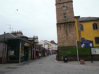
Bank Street from The Cross
- At it's north end near The Cross, Bank Street is marked via vertical poles on either side of the pavements.
- The south side pavement is easiest to use here as New Laigh Kirk is on the opposite side with restricted pavement areas.
- The south side is also easier to stick to as there are fewer crossings and dropped kerbs further down.
- There are regular bollards separating the south pavement from the lightly cobbled road.
- The one way road enters Bank Street here from John Dickie Street which is also a one-way street.
- Though some traffic may cross directly from John Dickie Street into the access lane of Sandbed Street rather than turning onto Bank Street.
- Care should therefore be taken in this area when crossing the Sandbed Street junction.
- The crossing is marked like a zebra crossing using the paved surface and light cobbled surface intermittently.
- Sandbed Lane is also one-way, so traffic should only enter from John Dickie Street, or the small section towards the cross before the pedestrianised area.
- There are bollards to prevent traffic entering The Cross towards King Street in the road here with paving on either side which should be stuck to if coming from the pedestrianised areas.
- There is also a crossing marked out like a zebra crossing if coming from John Dickie Street's pavement.
- Note that traffic may not notice these zebra crossing like markings and there are no lights to give indication so care must be taken when crossing.
- There are benches near the Johnnie Walker statue nearby on John Dickie Street.
New Laigh Kirk
- There are 3 of the zebra crossing like part-paved walkways over to New Laigh Kirk on the north side of the street.
- Two of the crossings lead to either side of a staircase entrance which has no pavement beyond on the north side.
- The further crossing to the south leads to a further entrance and the cobbled pavement on that side.
- There are 2 bollards on either side of the road at this crossing.
- There is a shallow gulley between the road and pavement areas here.
College Wynd
- There is a part-paved zebra like crossing over Bank Street to the south of College Wynd.
- There are bollards on both sides at the crossing.
- College Wynd is a narrow one-way street where traffic may turn into it from Bank Street.
- College Wynd can be crossed on the north Bank Street pavement towards New Laigh Kirk, although only to the cobbled paving area, so crossing here is recommended first.
- Both sides of Bank street are paved to the south of here, although the north side has more crossings to navigate.
Bank Street
- The central part of Bank Street has bollards every so often between the paving and central road.
- The south side also has additional low brick bollards in the road in front of a wider area near Bar Luca.
- Traffic may be crossing the pavement to or from the gated Bar Luca car park to the left as you face the building.
- The paving turns to cobbles at the car park entrance.
- There is a large bronze statue sitting on a bollard on the inside of the pavement.
- There is up-lighting surrounding the statue for when it is darker.
- This statue of a man reading was designed by local primary school children to indicate where the printing press was located nearby.
Bank Place Junction
- Bank Place is a one-way street that joins onto Bank Place from the north side.
- There is a part-paved zebra like crossing over Bank Place near the marked junction.
- There are dropped kerbs on both sides.
- There is not tactile paving.
- There is also a further crossing over Bank Street immediately to the north of the junction, in front of Bar Luca.
- There is a dropped kerb on the north side.
- Traffic may be crossing the pavement to or from the gated Bar Luca car park to the left as you face the building.
- There are low brick bollards on either side of the crossing at the south side.
- There are no lights to indicate these are crossings, so care must be taken in this area.
Underground Parking / No Parking Area
- There are dropped kerb access road areas to cross on the north side of the street near the Royal Bank of Scotland building.
- One of the roads leads to and from an underground car park for the bank.
- There are dropped kerbs to the inside of the pavement.
- There is no tactile paving although the access to the car park has a light cobbled surface like the street.
- Adjacent to the bank there is a road in which is marked as a no parking area, although with bollards down cars appear to use it.
- The dropped kerbs are not as level here and assistance may be required for the level change.
- There is no tactile paving and the road has a lightly cobbled surface.
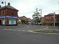
Nelson Street Junctions
- Towards the south end of Bank Street, Nelson Street joins on both sides.
- These are both one-way streets where traffic comes onto Bank Street.
- The street on the north side is narrow, with the south side being wider.
- There are dropped kerbs on all corners here.
- There is not tactile paving.
Bank Street to John Finnie Street
- There are paved surfaces on both sides to the north of the Nelson Street junctions.
- Beyond the junction there are paved surfaces to the south near John Finnie Street.
- The road surface also changes to tarmac beyond Nelson Street.
- There are some dropped kerbs for entrances to buildings and private car parks.
- The roadside bollards continue to the end of Bank Street on the south side.
- Bank Street bends round to join the one-way John Finnie Street with traffic turning right and heading north.
- There are dropped kerbs on both sides to cross near the John Finnie Street junction.
- The majority of shops and services on John Finnie Street lead north towards the train station.
- The south leads towards Kilmarnock Sheriff Court and St. Marnock Street.
Toilet Facilities
- The nearest public toilets are at Burns Mall Public Convenience within Burns Mall off The Cross.
- There is also a Changing Places facility at the bus station next to Burns Mall and Shopmobility.
- Please refer to the separate guides for details.
- Some venues along the route may also have their own customer toilet facilities available.
Access Guides Available For (Bank Street)
-
Shopping
View
- Flowers by Karen - To view the access guide please click here (new tab).
- A&J Raeburn - To view the access guide please click here (new tab).
- Forever Young - To view the access guide please click here (new tab).
- Blane Travel - To view the access guide please click here (new tab).
- Russel Dunlop Hair - To view the access guide please click here (new tab).
- Allure Hair and Beauty - To view the access guide please click here (new tab).
- McSherry Halliday - To view the access guide please click here (new tab).
- McSherry Halliday Solicitors - To view the access guide please click here (new tab).
- COVE Boutique - To view the access guide please click here (new tab).
- Dress Exchange - To view the access guide please click here (new tab).
- The Barber Shop - To view the access guide please click here (new tab).
- Toni - To view the access guide please click here (new tab).
- Love Is In The Hair - To view the access guide please click here (new tab).
- Allen & Harris - To view the access guide please click here (new tab).
- Eating and Drinking View
- Toilets View
- Other Services View