
Access Guide
Introduction
- This street guide is for High Street North between Barking Road (A124) and East Ham Tube Station.
- This section of the High Street North is approximately 700m (0.4 mile) long and takes around 10 minutes to walk.
Getting Here
- By Car
- The High Street North is located in the centre of East Ham in north east London, approximately 1.5km from the A13 Newham Way.
- By Bus
- There are multiple bus stops located along High Street North which are served by the 101, 104, 147, 238, 300, 325, 376 and 474 routes.
- By Train
- The nearest train station is the East Ham Station.
- This station is operated by the Overground Line.
- The station has step-free access.
- By Underground
- The nearest underground station is the East Ham Tube Station.
- This station is operated by the Hammersmith & City and District Line.
- There is step-free access at this station.
- To view a map of East Ham Tube Station please click here (opens in new tab).
Parking
- Public Car Parks
- The nearest public car park is Madge Gill Way Car Park, off Ron Leighton Road (shown in photographs 1 and 2). Please see the access guide for details.
- On-street Blue Badge Parking
- There are Blue Badge bays located on several side roads off High Street North. Please see local signs for details.
High Street North - Barking Road Access Point
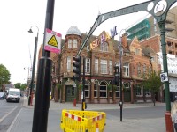
- The south end of High Street North is located off Barking Road opposite the High Street South.
- The pavement in this area is level with a concrete slab surface.
- There are multiple sign posts and bins in this area mainly along the kerb side of the pavement.
- The High Street North is a one-way road leading north from Barking Road up the High Street North.
- There is a traffic light controlled crossing to cross from the east to west side of High Street North.
- This crossing is level with tactile paving on both sides.
- This crossing has a rotating cone warning system but no audible warning and has control boxes 104cm high.
Barking Road to Ron Leighton Way
- The stretch of High Street North leading from Barking Road (A124) to Ron Leighton Way is approximately 500m in length.
- This section of the High Street North has a one way road leading north.
- The pavement along this stretch of the High Street North has a level concrete slab paving surface with little to no markings separating the road from the pavement.
- There is a slight gradient towards the centre of the pavement, along the east pavement between Barking Road and Ron Leighton Way.
- There are sections of market stalls and seating areas in front of shops between Barking Road and Myrtle Road on the west side of the pavement and between Kempton Road and Thorpe Road on the east side of the pavement.
- There are market stalls on the kerb side for approximately 15m on the north side of Pilgrims Way.
- There are multiple bins, sign posts and plants along the kerb side of the pavement on both sides of the High Street North.
- There is infrequent bench seating available along this stretch of the High Street North.
- The Kempton Road Bus Stop and Caledon Road Bus Stop are situated kerb side on the west side of High Street North between Myrtle Road and Pilgrims way and opposite Caledon Road.
- There is a traffic light controlled crossing to pass from the east to the west side of the pavement at the north end of the one-way section of the High Street North.
- This crossing is level with tactile paving on both sides.
- This crossing has visible but no audible signal.
- There are rotating cones for visually impaired users under the control units.
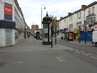
West Side of High Street North - Ron Leighton Way to East Ham Station Crossing
- The west section of High Street North between Ron Leighton Way and Heigham Road is even and level with a concrete slab surface.
- There are multiple signposts and bins along the kerb side of the pavement.
- There is a traffic light controlled crossing approximately 5m north of Ron Leighton Way which crosses to the east side of the High Street North.
- This crossing has tactile paving and dropped kerbs on both sides.
- This crossing has a rotating cone but no audible warning.
- The Bendish Road bus stop is located between the Bendish Road and Heigham Road crossings.
- The bus stop is situated on the kerb side of the pavement and is provided with bench seating.
- The bus stop may cause congestion on the pavement.
- There is a slight gradient on the north side of the Heigham Road crossing for approximately 50m, leading up to the East Ham Station Crossing.
Ron Leighton Way and Bendish Road Crossing
- The Ron Leighton Way crossing is a traffic light controlled crossing on the east side of the street.
- This crossing has tactile paving with a dropped kerb on both sides.
- This crossing has a rotating cone with no audible warning.
- This is a busy road crossing.
- The Bendish Road crossing is an uncontrolled road crossing.
- This crossing is level with no tactile paving.
Myrtle Road
- Myrtle Road is a short side road leading off the west side of High Street North.
- The pavements are wide and level.
- They are flush with the road surface which is block paving.
- There are some trees and cycle racks set into the pavement.
- There is some bench seating in this area, near to Sainsbury's.
Lloyd/Thorpe/Kempton/Myrtle/Skeffington/Caledon/Caulfield and Pilgrims Way Crossings
- There are multiple road crossings along both sides of the High Street North.
- These road crossings are level with no tactile paving.
- Lloyd Road, Kempton Road and Caledon Road are all one-way roads leading off the east side of High Street North.
- Thorpe Road, Skeffington Road and Caulfield Road are all one-way roads leading off the east side of High Street North.
- Myrtle Road and Pilgrims Way are narrow, quiet, two-way roads leading off the west of High Street North.
Heigham/Burges Road Box Junction
- The Heigham Road and Burges Road Box Junction High Street North crossing consists of 4 similar traffic light controlled crossings, one across each road entering the crossing.
- These two crossings are approximately 5m from the Heigham and Burges Road crossings.
- These road crossings are traffic light controlled with tactile paving and a dropped kerb on both sides.
- These crossings have audible and rotating cone warning systems.
- The Heigham Road crossing is a traffic light controlled crossing with tactile paving and dropped kerbs on both sides.
- This crossing has a rotating cone warning system but no audible warning.
- The Burges Road crossing is a traffic light controlled crossing with tactile paving and dropped kerbs on both sides.
- This crossing has a rotating cone warning system but no audible warning.
East Side of High Street North - Clements Road to the East Ham Station
- The east section of High Street North between Clements Road and Burges Road has even and level concrete slab paving.
- There are multiple signs, bins and trees along the kerb side of the pavement.
- There is a traffic light crossing to the west side of High Street North, approximately 10m north of the Clements Road crossing.
- The Bendish Road Bus Stop (Stop N) is situated on the kerb side of the pavement between Clements Road and Lanthom Road.
- This bus stop has bench seating and may cause a congested pavement.
- There is a slight gradient leading from Burges Road to the East Ham Tube Station for approximately 20m. This slope has a concrete block surface.
- Along this stretch of pavement there are multiple trees in the centre of the pavement and multiple obstacles on the kerb side of the pavement including cycle racks, phone boxes, bins and sign posts.
- There is a minicab company car park exit approximately 20m from the East Ham Tube Station; there is no dropped kerb or tactile paving to mark this crossing.
Clements Road and Lathom Road Crossing
- The Clements Road crossing is a traffic light controlled crossing shown in photographs 1 and 2.
- This crossing has tactile paving and dropped kerbs on both sides.
- This crossing has rotating cone warning system with no audible warning and a control box 102cm high.
- The Lathom Road crossing is shown in photographs 3 and 4.
- This crossing is level with no tactile paving.
East Ham Tube Station Crossing
- The East Ham Tube Station crossing is located directly outside the main entrance to the East Ham Tube Station.
- This is a traffic light controlled crossing.
- This crossing has dropped kerbs and tactile paving on both sides.
- The dropped kerb on the east side of the crossing (shown in photograph 2) is across the pavement instead of on the kerb.
- This crossing has an audible warning system and rotating cones.
Accessible Toilet
- The McDonald's at 28 - 32 High Street North is part of the Community Toilet Scheme and makes its accessible toilet available to non-customers during normal opening hours.
- There may be further accessible toilets within the shops and retail areas along the High Street North and in the surrounding area.
Standard Toilet(s)
- The McDonald's at 28 - 32 High Street North is part of the Community Toilet Scheme and makes its standard toilets and baby change facilities available to non-customers during normal opening hours.
- There may be further standard toilets within the shops and retail areas along the High Street North and in the surrounding area.
Access Guides Available For (East Ham Shopping Area)
-
Shopping
View
- Alf Onnie - To view the access guide please click here (new tab).
- Argos - To view the access guide please click here (new tab).
- Boots Pharmacy - To view the access guide please click here (new tab).
- Deeps Footwear - To view the access guide please click here (new tab).
- East - To view the access guide please click here (new tab).
- EBR Attridge Solicitors LLP - To view the access guide please click here (new tab).
- EE - To view the access guide please click here (new tab).
- Fashion Stop Schoolwear - To view the access guide please click here (new tab).
- Fast EnCash - To view the access guide please click here (new tab).
- Fish Brothers - To view the access guide please click here (new tab).
- Fix4U Ltd - To view the access guide please click here (new tab).
- Gaming Fun - To view the access guide please click here (new tab).
- Holland and Barrett - To view the access guide please click here (new tab).
- Iceland - To view the access guide please click here (new tab).
- iGame - To view the access guide please click here (new tab).
- Khan's - To view the access guide please click here (new tab).
- Lidl - To view the access guide please click here (new tab).
- Neil Gordon Opticians - To view the access guide please click here (new tab).
- Party Invitation Ltd - To view the access guide please click here (new tab).
- Poundland - To view the access guide please click here (new tab).
- Preece Meats - To view the access guide please click here (new tab).
- Sainsbury's - To view the access guide please click here (new tab).
- Sam 99p - To view the access guide please click here (new tab).
- Shoe Zone - To view the access guide please click here (new tab).
- Slick Clothing Ltd - To view the access guide please click here (new tab).
- Superdrug - To view the access guide please click here (new tab).
- Swayam - To view the access guide please click here (new tab).
- Tiffin Shop - To view the access guide please click here (new tab).
- Wilko - To view the access guide please click here (new tab).
- Works - To view the access guide please click here (new tab).
-
Eating and Drinking
View
- Costa - To view the access guide please click here (new tab).
- German Doner Kebab - To view the access guide please click here (new tab).
- Greggs (95 High Street North) - To view the access guide please click here (new tab).
- Greggs (158 High Street North) - To view the access guide please click here (new tab).
- McDonald's - To view the access guide please click here (new tab).
- Pepe's Piri Piri - To view the access guide please click here (new tab).
- Subway - To view the access guide please click here (new tab).
- Leisure and Entertainment View
- Car Parks View
- Other Services View