
Access Guide
Introduction
- This guides describes the shopping and leisure area of A114 Woodgrange Road in Forest Gate.
It covers the area from Wanstead Park Station in the north to the junction with Romford Road in the south and includes the area around Forest Gate Station.
The distance from Wanstead Park Station to Forest Gate Station is around 300m (0.2 mile) and takes around 5 minutes to walk.
It is a similar distance from Forest Gate Station to Romford Road.
There are long slopes on the approaches to Forest Gate station from both directions.
In other areas the paths are generally level.
Potential hazards in the area include A-board signs and other obstructions on the pavement.
-
Comments
View
- This survey was carried out in June 2019 when there were major construction works on the highway to improve the area around Forest Gate Station.
- This affects the area between Brooking Road and Earlham Road and will involve new road and footpath surfaces and improved junctions.
- Work is expected to be complete by late 2019.
- There is a development site on the west side of Woodgrange Road south of Earlham Road.
- The church on the opposite side of the road is due to be demolished and redeveloped.
- Both of these works may result in temporary closures and diversions of footpaths and parking areas.
Getting Here
- By Car
- The A114 Woodgrange Road runs north-south.
- Further north it passes though Wanstead Flats to connect to the A12.
- To the south, the road continues south of the junction with the A118 Romford Road.
- Romford Road connects with the A12 to the west and the A406 North Circular Road to the east.
- By Bus
- There are bus stops on both sides of the road and near to the two train stations.
- The stops are served by routes 58, 308 and 330.
- By Train
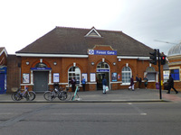
- Forest Gate Station is served by TFL Rail services between London Liverpool Street and Shenfield via Stratford.
- In future, it will also be served by the Elizabeth Line (Crossrail services).
- There is level access to the platforms by lift and staff to assist with boarding ramps.
- Wanstead Park Station is served by London Overground services between Barking and Gospel Oak.
- Access to both platforms at this station is by long flights of stairs.
- Please see the linked access guides for full details of these stations.
Parking
- Car Parks
- There are no public car parks in this area.
- Blue Badge Parking
- There are three Blue Badge bays outside the Lord Lister Health Centre, close to Wanstead Park Station (shown in photographs 1 and 2).
- These are limited to 3 hours Monday to Saturday, 08.00 - 18.30.
- There is a single Blue Badge bay on the side road Osborne Road, off the south east side of Woodgrange Road.
- This is outside the Woodgrange Medical Practice (shown in photograph 3).
- It is reserved for resident Blue Badge holders only.
- There is a further single bay on Claremont Road close by.
- On-Street Standard Parking
- There are standard pay-by-phone parking bays outside the Lord Lister Health Centre.
- There are also bays on the north-east side of Woodgrange Road, which are in lay-bys level with the pavement (shown in photograph 4).
- Towards the southern end of the road there are long strips of on-street parking to both sides of the road (shown in photographs 5 and 6).
- All of these bays are pay-by-phone.
- Most are limited to 2 hours, 09.00 - 17.00 Monday to Friday.
- A small number are also used for loading and are restricted to 30 minutes parking 10.00 - 16.00.
- Check local signs for details.
- There are further on-street parking bays in many of the side roads which are pay-and-display with ticket machines available.
Crossing Point - Near Wanstead Park Station
- There is a zebra crossing just south of Wanstead Park Station and close to the Lord Lister Health Centre.
- There are dropped kerbs to both sides of the road, marked with tactile paving.
- There is also a level surface central refuge, also marked with tactile paving, so the road can be crossed in two stages.
Woodgrange Road - Wanstead Park Station to Forest Lane - East Side
- Close to Wanstead Park station, the pavements on both sides of the road are wide and level.
- There are dropped kerbs with tactile paving and bollards to mark the entrance to an access road next to the railway bridge (shown in photograph 1).
- The entrance to the car park for a residential development is level.
- It is marked by large wooden planters, but not tactile paving (shown in photographs 2 and 3).
- The pavement is narrower where there are bus stops and telephone boxes (shown in photograph 4).
- At the junction with the side road Sebert Road the crossing point is marked by tactile paving and there are steep temporary ramps in place (shown in photographs 6 and 7).
- South of Sebert Road, a wide open area of block paving has been created (shown in photographs 8 and 9).
- There are some street trees in this area and plans to add more seating.
- There may be market stalls in this area sometimes.
- There are long uphill slopes on the approach towards Forest Gate station from this area (shown in photograph 10).
Woodgrange Road - Wanstead Park Station to Forest Lane - West Side
- South of the zebra crossing, the pavements are wide and level close to the Lord Lister Health Centre.
- At the junction with the side road Brooking Road there are steep dropped kerbs with tactile paving (shown in photographs 2 and 3).
- Between Brooking Road and Forest Lane, the footpath is level but narrower (shown in photographs 4 and 5).
- It broadens out at the junction with Forest Lane (shown in photograph 6).
- There is a dished drainage channel in the centre of the footpath in this area.
Crossing Points - Junction of Woodgrange Road and Forest Lane
- There are pedestrian controlled crossing points on Forest Lane and on Woodgrange Road both north and south of the junction.
- All the crossings have dropped kerbs and tactile paving.
- There are visible but not audible signals at the crossings.
- All have rotating cones under the controls for visually impaired users.
- On Forest Lane there is a large central island which also has dropped kerbs and tactile paving (shown in photographs 1 - 3).
- This road is crossed in two stages.
- Photographs 4 - 6 show the two crossings on Woodgrange Lane near to the station.
Woodgrange Road - Forest Gate Station to Romford Road - East Side
- From the south, the slope uphill towards the station starts at the side road, Hampton Road (shown in photographs 1 - 2).
- Between Hampton Road and the crossroads with Romford Road the pavements are generally wide and level (shown in photographs 3 - 6).
- There are some trees, bins, telephone boxes and utility boxes in the centre of the pavement.
- Where there are cycle racks these are close to the edge of the pavement.
- There are four side roads joining Woodgrange Road in this section; Hampton Road, Osborne Road, Claremont Road and Post Office Approach.
- Each junction is marked by tactile paving and the road surface is raised level with the pavement (shown in photographs 7 - 9).
- Redevelopment works were ongoing at the time of revisit (July 2023) between Osborne Road and Claremont Road.
Woodgrange Road - Forest Gate Station to Romford Road - West Side
- The long uphill slope towards Forest Gate station runs from the side road Earlham Grove right up to the station entrance (shown in photographs 1 - 2).
- There are cycle racks on the road edge of the pavement and between the pavement and the taxi waiting area which is level with the pavement (shown in photograph 3).
- The junction with Earlham Grove was under reconstruction at the time of revisit (July 2023).
- At the time of our visit there were steep, temporary ramps at the tactile paving marking the crossing point.
- These do not line up with the refuge between the vehicle lane and the cycle path (shown in photographs 4 and 5).
- Caution is needed - vehicles are one-way out of the side road onto the main road, but cycles are one-way turning into the side road.
- Between Earlham Grove and the junction with Romford Road the pavement is generally level.
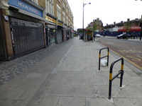
- It may be narrower than usual where there are hoardings around the construction site (shown in photograph 6).
- There are lampposts, sign posts, telephone boxes and utility boxes in the pavement.
- There is no seating in this section.
- There is a crossing point at the junction with a side access road between Percy Ingle Bakery and the pharmacy (shown in photographs 9 and 10).
- There are dropped kerbs with tactile paving at the crossing, but some surfaces are uneven.
Crossing Points - Near Osborne Road and Post Office Approach
- There is a pedestrian controlled crossing point just south of Earlham Grove and Osborne Road (shown in photographs 1 and 2).
- This is outside the Woodgrange Medical Practice.
- The crossing has dropped kerbs with tactile paving on both sides.
- There are audible and visual signals and rotating cones on the control points.
- There is a similar crossing with the same features near to Post Office Approach, outside Poundland (shown in photographs 3 and 4).
Crossing Points - Junction of Woodgrange Road with Romford Road
- There is a pedestrian controlled crossing point on Woodgrange Road just before the crossroads with Romford Road and Upton Lane (shown in photographs 1 and 2).
- The crossing has dropped kerbs with tactile paving.
- There is an off-set central refuge with a level surface and tactile paving.
- The road is crossed in two stages.
- The crossing has visual signals and rotating cones but not audible signals.
- There are similar crossing points on Romford Road on both sides of the crossroads and also south of the junction on Upton Lane (shown in photographs 3 and 4).
Forest gate station to Earlham Grove
- As you exit the station, the pavement is sloped until it reaches a level crossing at Earlham grove which has tactile paving. There is then a pedestrian crossing immediately in front of you.
- Earlham Grove has been narrowed slightly by a plant box in the road and has a cycle path along the left hand side.
- There is parking along the sloped Road to the right of the station, max stay is 30 minutes and pay by phone.
- As you cross the tactile paving at Earlham Grove there is a set of traffic lights on the left which has extended tactile paving.
- Ongoing construction as of 2021 in this area.
Accessible Toilet
- The borough operates a community toilet scheme.
- The accessible toilet in The Gate Library and Community Centre (close to the junction with Romford Road) is available for public use during normal hours (08.00 - 20.00 Monday to Friday, 10.30 - 20.00 Saturday, closed Sundays).
- Please see the related access guide for details.
- Outside of these hours, the nearest community toilet is in McDonald's, approximately 150m away on Romford Road.
- Cafes and restaurants in the area will also have toilets for customer use. Please see the linked access guides for details.
Standard Toilet(s)
- Standard toilets and baby change facilities are available in The Gate and McDonald's for public use and in local cafes for customer use.
- Please see linked access guides for details.
Access Guides Available For (Forest Gate Shopping Area - Woodgrange Road)
-
Shopping
View
- Angie's Stock Shop - To view the access guide please click here (new tab).
- Aston Mansfield - To view the access guide please click here (new tab).
- Co-op - To view the access guide please click here (new tab).
- H&T Pawnbrokers - To view the access guide please click here (new tab).
- Iceland - To view the access guide please click here (new tab).
- Madinah Drycleaners - To view the access guide please click here (new tab).
- Map Express Cargo Ltd - To view the access guide please click here (new tab).
- MK Bros - To view the access guide please click here (new tab).
- Poundland - To view the access guide please click here (new tab).
- Pradip Patel Ltd - To view the access guide please click here (new tab).
- Salama Global - To view the access guide please click here (new tab).
- Superdrug - To view the access guide please click here (new tab).
- Tesco Express - To view the access guide please click here (new tab).
- Tiger Tailoring - To view the access guide please click here (new tab).
- Travoliday - To view the access guide please click here (new tab).
- Vaping House - To view the access guide please click here (new tab).
- Woodgrange News - To view the access guide please click here (new tab).
-
Eating and Drinking
View
- Coffee of Italy - To view the access guide please click here (new tab).
- KFC - To view the access guide please click here (new tab).
- Moon House - To view the access guide please click here (new tab).
- Pizza Hut - To view the access guide please click here (new tab).
- Subway - To view the access guide please click here (new tab).
-
Other Services
View
- Wanstead Park Overground Station - To view the access guide please click here (new tab).
- Forest Gate Station - To view the access guide please click here (new tab).
- The Gate Library and Community Centre - To view the access guide please click here (new tab).
- Gilderson & Sons - To view the access guide please click here (new tab).
- Lord Lister Health Centre - To view the DisabledGo access guide please click here (new tab).