
Access Guide
Location
- There is a bus stop within 150m (164yds) of the venue.
- The nearest National Rail station is Milngavie.
Parking
- The venue does have its own car park.
-
Venue Car Park
View
- Parking is free for all users.
- The car park is located off Main Street (B8030).
- The car park type is open air/surface.
- There is/are 0 Blue Badge parking bay(s) within the car park.
- The route from the car park to the entrance is accessible to a wheelchair user with assistance.
- Assistance may be required because there is/are uneven surfaces.
- The car park surface is tarmac.
- There is a dropped kerb between the car park and the venue.
- The dropped kerb does not have tactile paving.
- There is not a road to cross between the car park and the entrance.
- The car park does not have a height restriction barrier.
-
Drop-off Point
View
- There is not a designated drop off point.
Access Point (Main Street Car Park Entrance)
-
Access Point
View
- This information is for the access point located to the rear of the car park.
- There is not an information board/map at this access point.
- There is ramped/sloped access at this access point.
- There is no gate at this access point.
-
Ramp/Slope
View
- The ramp/slope is located leading down beyond the entrance.
- The gradient of the ramp/slope is slight.
- The ramp/slope is permanent.
- There is not a level landing at the top of the ramp/slope.
- There is not a/are not handrail(s) at the ramp.
Access Point (Main Street Bus Stop Stepped Entrance)
-
Access Point
View
- This information is for the access point located on Main Street, to the left of the bus shelter.
- There is not an information board/map at this access point.
- There is stepped access at this access point.
- There is no gate at this access point.
-
Step(s)
View
- The step(s) is/are located leading down into the park.
- There is/are 9 step(s).
- The step(s) is/are not clearly marked.
- The height of the step(s) is/are between 15cm and 18cm.
- The height of the step(s) is/are 16cm.
- The going of the step(s) is/are not between 30cm and 45cm.
- There is not a/are not handrail(s) at the step(s).
-
Comments
View
- There are 2 steps beside the bus stop, 4 further along the path, and 3 to the right of a café building here.
- The car park entrance is approximately 50m to the left from here, offering an easy slope.
- The main entrance is approximately 50m to the right from here, offering a steep slope.
Access Point (Main Entrance)
-
Access Point
View
- This information is for the access point located at the crossroad junction with Main Street and Keystone Avenue.
- There is not an information board/map at this access point.
- There is ramped/sloped or stepped access at this access point.
- There is no gate at this access point.
-
Ramp/Slope
View
- The ramp/slope is located leading down to the right of the steps.
- The gradient of the ramp/slope is steep.
- The ramp/slope is permanent.
- There is a level landing at the top of the ramp/slope.
- There is a/are handrail(s) at the ramp.
- The handrail(s) is/are on the left going up.
- The ramp/slope does bypass the step(s).
-
Step(s)
View
- The step(s) is/are located leading down beyond the entrance.
- There is/are 11 step(s).
- The step(s) is/are not clearly marked.
- The height of the step(s) is/are between 15cm and 18cm.
- The height of the step(s) is/are 17cm.
- The going of the step(s) is/are between 30cm and 45cm.
- There is not a/are not handrail(s) at the step(s).
-
Comments
View
- Main Street car park entrance, approximately 100m to the left from this entrance offers an easy slope.
- Keystone Avenue entrance, approximately 100m to the right from this entrance offers a long easy slope.
- Main Street car park entrance, approximately 100m to the left from this entrance offers an easy slope.
Access Point (Keystone Avenue Entrance)
-
Access Point
View
- This information is for the access point located on Keystone Avenue.
- There is not an information board/map at this access point.
- There is ramped/sloped access at this access point.
- There is no gate at this access point.
-
Ramp/Slope
View
- The ramp/slope is located beyond the entrance.
- The gradient of the ramp/slope is slight.
- The ramp/slope is permanent.
- There is not a/are not handrail(s) at the ramp.
Access Point (Keystone Avenue Stepped Entrance)
-
Access Point
View
- This information is for the access point located on Keystone Avenue.
- There is not an information board/map at this access point.
- There is ramped/sloped and stepped access at this access point.
- There is no gate at this access point.
-
Ramp/Slope
View
- The ramp/slope is located leading up beyond the steps.
- The gradient of the ramp/slope is slight.
- The ramp/slope is permanent.
- The ramp/slope does not bypass the step(s).
-
Step(s)
View
- The step(s) is/are located leading up beyond the entrance.
- There is/are 6 step(s).
- The step(s) is/are not clearly marked.
- The height of the step(s) is/are between 15cm and 18cm.
- The height of the step(s) is/are 15cm.
- The going of the step(s) is/are between 30cm and 45cm.
- There is not a/are not handrail(s) at the step(s).
Access Point (Allander Walkway Keystone Avenue Entrance)
-
Access Point
View
- This information is for the access point located on Keystone Avenue, towards Glasgow Road.
- There is not an information board/map at this access point.
- There is ramped/sloped access at this access point.
- There is no gate at this access point.
-
Ramp/Slope
View
- The ramp/slope is located beyond the entrance.
- The gradient of the ramp/slope is slight.
- The ramp/slope is permanent.
- There is not a/are not handrail(s) at the ramp.
-
Comments
View
- There is a long steep ramp to the left beyond this entrance, parallel to Keystone Avenue.
Access Point (Allander Walkway Entrance)
-
Access Point
View
- This information is for the access point located at the Allander Water bridge near the Main Street underpass to the town centre, next to the Tesco car park.
- There is not an information board/map at this access point.
- There is ramped/sloped access at this access point.
- There is no gate at this access point.
-
Ramp/Slope
View
- The ramp/slope is located leading down to and beyond the entrance.
- The gradient of the ramp/slope is slight.
- The ramp/slope is permanent.
-
Comments
View
- There is a long slope down from the town centre underpass.
- There is also an easy slope to the left beyond this entrance along Allander Water towards the supermarket.
- There is a long slope down from the town centre underpass.
Access Point (Allander Walkway Tesco Entrance)
-
Access Point
View
- This information is for the access point located to the right of the Tesco supermarket entrance, past the ATM's.
- There is not an information board/map at this access point.
- There is ramped/sloped access at this access point.
- There is no gate at this access point.
-
Ramp/Slope
View
- The ramp/slope is located beyond the entrance, leading down alongside Allander Water.
- The gradient of the ramp/slope is slight.
- The ramp/slope is permanent.
- There is a/are handrail(s) at the ramp.
- The handrail(s) is/are on the left going up.
-
Comments
View
- There is a steep slope up the compact earth path to the right beyond this entrance, leading to the grass pitches.
Access Point (Milngavie Railway Station Entrance)
-
Access Point
View
- This information is for the access point located adjacent to Milngavie Railway Station and Tesco car park.
- There is not an information board/map at this access point.
- There is ramped/sloped access at this access point.
- There is no gate at this access point.
-
Ramp/Slope
View
- The ramp/slope is located leading up to the park from beside the railway.
- The gradient of the ramp/slope is slight.
- The ramp/slope is permanent.
-
Comments
View
- Continuing along the tarmac path from this entrance leads to 15+ steps beyond the grass pitches.
- There is an easy slope over a compact earth path which leads to the other side of the pitches and further slopes which bypass the steps.
- Continuing along the tarmac path from this entrance leads to 15+ steps beyond the grass pitches.
Access Point (Railway Bridge Entrance)
-
Access Point
View
- This information is for the access point located at the railway bridge near Crossveggate and Viewpark.
- There is not an information board/map at this access point.
- There is ramped/sloped access at this access point.
- There is no gate at this access point.
- There are bollards at this access point.
-
Ramp/Slope
View
- The ramp/slope is located leading up to the bridge from Crossveggate.
- The gradient of the ramp/slope is slight.
- The ramp/slope is permanent.
- There is a level landing at the top of the ramp/slope.
-
Comments
View
- Following the tarmac path to the left from this entrance leads to 15+ steps beyond the grass pitches.
- There is an easy slope over a compact earth path to the right from this entrance which leads to the other side of the pitches and further slopes which bypass the steps.
- Following the tarmac path to the left from this entrance leads to 15+ steps beyond the grass pitches.
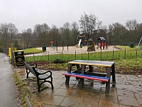
Parks and Gardens
- The park or garden does have footpaths.
- The path(s) has a / have compact earth and tarmac surface(s).
- The majority of the path(s) is / are wide enough for wheelchair users.
- There are steep, moderate and slight slopes on the paths.
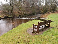
- There are some bench seats situated along the paths for people to rest.
-
Comments
View
- There are 8 steps with handrails on both sides near the Allander Water bridge which can be bypassed using easy slopes to the left of them.
- There are 15+ steps with a handrail to the right near the rear sports pitches which can be bypassed using long easy slopes nearer Allander Water.
- There are 8 steps with handrails on both sides near the Allander Water bridge which can be bypassed using easy slopes to the left of them.