
Access Guide
Introduction - Shrek's Adventure Gift Shop
- The Shrek's Adventure Gift Shop is located on Queen's Walk.
- It can be accessed via Queens Walk or at the of the Shrek's Adventure experience.
Getting Here
-
By Air
View
- The nearest airports to central London are London City Airport, London Gatwick and London Heathrow.
London City Airport is connected to the centre by the Docklands Light Railway (DLR) to Bank or Tower Gateway with interchanges to the rail and underground network at Canning Town and Stratford.
From Gatwick Airport there are fast trains connecting to London Bridge Station.
Heathrow Airport is connected by fast trains to Paddington Station and is also on the Piccadilly underground line. - For more information on travelling to London by air please click here (opens new tab).
- The nearest airports to central London are London City Airport, London Gatwick and London Heathrow.
-
By Road
View
- County Hall is situated in central London in the Congestion Zone.
County Hall is located in Belvedere Road.
Belvedere Road can be accessed from Westminster Bridge Road or York Road (both A3200).
It may be easier to use public transport to access the County Hall.
There is a taxi rank on Chicheley Street. - There is no on-site parking. Please see the section on London South Bank Car Parks for more information on nearby public parking.
There is coach parking only along Belvedere Road.
There is Blue Badge and standard on-street parking on Chicheley Street. - For more information on London traffic please click here (opens new tab).
- County Hall is situated in central London in the Congestion Zone.
-
By Bus
View
- There is a bus stop within 150 metres of the venue.
- There are tourist bus stops for the London Eye on Belvedere Road.
There is also a London Eye public bus stop on Chicheley Street which is serviced by RV1 buses. - For more information on London Buses (Transport for London) please click here (opens new tab).
-
By Train
View
- The nearest Railway Station is Waterloo/Waterloo East.
- Waterloo and Waterloo East Stations are approximately 600m from County Hall.
The stations are linked and there is step-free access throughout the stations, although there are steep ramps to access the platforms in Waterloo East.
Step-free access to both stations is from the service road known as Cab Road or Taxi Road. - For more information on Waterloo Station (National Rail) please click here (opens new tab).
- For more information on Waterloo Station (AccessAble) please click here (opens new tab).
-
By Underground
View
- The nearest underground station is Waterloo.
- The nearest underground station is at Waterloo, served by the Northern, Bakerloo, Waterloo and City and the Jubilee Lines.
Of these, only the Jubilee Line has step-free access.
Embankment Station is on the north side of the river, near to the Golden Jubilee Bridges.
This station serves the District and Circle Lines as well as the Northern and Bakerloo lines.
Embankment Station does not have step-free access. - For more information on London Underground (Transport for London) please click here (opens new tab).
-
By River
View
- Six TFL River Bus routes run from 22 piers between Putney and Woolwich.
The Queen's Walk is served by the London Eye Millennium Pier, between Westminster Bridge and the Golden Jubilee Bridges and also Bankside Pier, to the east of Blackfriars Bridge.
There is step-free access onto the river buses, except three piers. Please see the TFL website for details. - For more information on London River Bus services please click here (opens new tab).
- Six TFL River Bus routes run from 22 piers between Putney and Woolwich.
-
Useful Links
View
- Please use the TFL journey planner for details of the most suitable route.
- To view the web page described above click here (opens in new tab).
- The TFL website has links to the TFL accessibility guides, including large print maps and audio guides to order or download.
- To view the web page described above click here (opens in new tab).
Getting Help and Assistance
- Accessibility Guide please click here (new tab).
- There is a member of staff available for help and assistance.
- There is not a member of staff trained in British Sign Language.
- There is not an assistance dog toilet or toileting area at the venue/nearby.
- Water bowls for assistance dogs are available.
- There are not mobility aids available.
South Bank Public Car Parks
- This section provides information about a number of public cars parks around South Bank.
For more information about access and parking charges please visit the individual car parks.
South Bank is located in the congestion charging zone.
-
National Theatre Car Park
View
- The National Theatre Car Park Car Park is located off Upper Ground.
- The car park type is underground.
- The car park does have Blue Badge parking.
- Parking is not free for Blue Badge holders.
- The car park surface is concrete.
- When the National Theatre building is closed there is no step-free access from the car park.
This applies all day on Sundays, and before 09.30 and after 23:00 on most other days.
Free parking is available in the NT Car Park for Blue Badge holders attending a performance or eating at the National.
Photographs 1 and 2 show the National Theatre Car Park. - To view the National Theatre car park location please click here (opens new tab).
- For more information on the National Theatre Car Park please click here (opens new tab).
-
Cornwall Road Car Park
View
- The Cornwall Road Car Park Car Park is located off Cornwall Road.
- The car park type is underground.
- The car park does have Blue Badge parking.
- Parking is not free for Blue Badge holders.
- The car park surface is concrete.
- There is step free access from the car park via a lift.
The car park is used as a car park for South Bank Centre Venues.
Photographs 3 and 4 Show the Cornwall Road Car Park. - To view the Cornwall Road car park location please click here (opens new tab).
- For more information on the Cornwall Road Car Park please click here (opens new tab).
-
Doon Street Car Park
View
- The Doon Street Car Park Car Park is located off Upper Ground.
- The car park type is open air/surface.
- The car park does not have Blue Badge parking.
- Parking is not free for Blue Badge holders.
- The car park surface is compacted gravel.
- Photographs 5 and 6 show the Doon Street Car Park.
- To view the Doon Street car park location please click here (opens new tab).
- For more information on the Doon Street Car Park please click here (opens new tab).
-
Waterloo – York Road Car Park
View
- The Waterloo York Road Car Park Car Park is located off York Road.
- The car park type is open air/surface.
- The car park does not have Blue Badge parking.
- Parking is not free for Blue Badge holders.
- The car park surface is tarmac.
- Photographs 7 and 8 show the Waterloo York Road Car Park.
- To view the Waterloo York Road car park location please click here (opens new tab).
- For more information on the Waterloo York Road Car Park please click here (opens new tab).
-
Waterloo – Upper Marsh Car Park
View
- The Waterloo Upper Marsh Car Park Car Park is located off Upper Marsh.
- The car park type is open air/surface.
- The car park does have Blue Badge parking.
- Parking is not free for Blue Badge holders.
- The car park surface is tarmac.
- Photographs 9 and 10 show the Waterloo Upper Marsh Car Park.
- To view the Waterloo Upper Marsh car park location please click here (opens new tab).
- For more information on the Waterloo Upper Marsh Car Park please click here (opens new tab).
-
London Waterloo Station Car Park
View
- The London Waterloo Station Car Park Car Park is located on Station Approach.
- The car park type is open air/surface.
- The car park does have Blue Badge parking.
- Parking is not free for Blue Badge holders.
- The car park surface is tarmac.
- Photographs 11 and 12 show the London Waterloo Station Car Park.
- To view the London Waterloo Station car park location please click here (opens new tab).
- For more information on the London Waterloo Station Car Park please click here (opens new tab).
Outside Access (Gift Shop Entrance)
-
Entrance
View
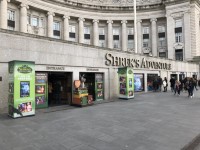
- This information is for the entrance located along The Queen's Walk.
- The entrance area/door is clearly signed.
- There is step-free access at this entrance.
- There is not a canopy or recess which provides weather protection at this entrance.
- The entrance door(s) does/do contrast visually with its immediate surroundings.
- The main door(s) open(s) away from you (push).
- The door(s) is/are double width.
- The door(s) is/are permanently held open.
- The width of the door opening is 156cm.
- There is a slope with a very easy incline.
Shop (Gift Shop)
-
Inside Access
View
- There is step free access to the majority of the venue/service.
- There is room to manoeuvre within the majority of the shop.
- The majority of aisle widths are not 150cm+.
- The aisle widths range between 85cm and 140cm.
- There is a clear accessible route to the till(s)/counter(s).
- The height of the till/counter is 120cm.
- The height of the lowered section of the refreshment counter is 70cm.
- The till(s)/counter(s) is/are placed in front of a background which is patterned.
- There are not windows, TVs, glazed screens or mirrors behind the till point(s)/counter(s) which could adversely affect the ability of someone to lip read.
- There is a hearing assistance system available at the till(s)/counter(s).
- Staff are not trained to use the hearing assistance system.
- There is not a seat/chair available.
- The type of flooring in the shop is laminate.
- There is some flooring which is shiny and could cause issues with glare or look slippery to some people.
- The lighting levels are varied.
-
Additional Information
View
- Photographic prints previously ordered at the ordering collection point can be collected by production of a receipt at the print collection point. The print collection point is on the left as you enter the shop (photograph 1).
Accessible Toilet(s)
- There is not an/are not accessible toilet(s) for public use.
Standard Toilet(s)
- Standard toilet facilities are not available.