
Access Guide
Introduction
- This guide covers the main shopping area of Newtownards High Street and Regents Street / Frances Street.
. - The route runs between the junction/roundabout of Fredrick Street, William Street and Church Street into Regents Street at its west end.
. - The route runs in a loop on Regents Street to Frances Street, Castle Place, High Street, Conway Square, High Street, Mill Street and then Gibsons Lane and the back into Regents Street.
. - The route is approximately 0.7 miles (1127m) and takes approximately 8-10 minutes to walk.
. - The shopping area is on both sides of the road.
. - Pathway surfaces are a mixture paving slabs, block paving and tarmac.
. - The pathways have some uneven sections, which include some raised manhole covers.
. - The road surfaces are tarmac, with dropped kerbs and tactile paving at most crossing points.
. - There are opportunities to sit and rest.
Getting Here
- By Car
- The A21 George Street is approximately 0.2 miles away via Castle Street and Portaferry Road.
- The route runs through the main shopping area of Newtownards from the west to east through the town centre.
- At the west end the route begins/ends where Frederick Street, Church Street and William Street meet.
- At the east end the route begins/ends where Castle Street, High Street and Movilla Street meet.
- Parking
- There is on street Blue Badge and standard parking available on High Street, Castle Street, Francis Street and surrounding roads.
- There are also several public car parks available off High Street and Francis Street.
- By Bus
- There are several bus stops available along High Street and Francis Street.
- The bus stops have direct services available to Bangor, Donaghadee, Ballywater, Belfast and Newtownards.
- For more information on Translink please click here
- By Train
- Bangor Train Station is approximately 4.9 miles away in Abbey Street.
- There is not step-free access to any of the platforms at this station.
- There are direct train services available to Portadown, Newry, Lanyon Place and Belfast.
- For more information on Translink please click here.
Junction - Frederick Street, William Street, Church Street and Regents Street
- There is a crossing point over Frederick Street, a crossing point over William Street, Church Street and over Regents Street.
- Photographs 1-14 show the crossings at this junction.
- These crossings have dropped kerbs and tactile paving on both sides.
- The pedestrian crossing has dropped kerbs, tactile paving on both sides and shows the green and red man symbol.
- The push button is 85cm high.
- The surface of the roads is tarmac.
- The surface of the pathways is paved.
Church Street, Gibson Street via Regents Street
- Photographs 1-5 show the side road crossings over the entrances to Newtownards Courthouse and into the rear of the Spirit of Merchant Public House.
- The distance between the bollards is 110cm.
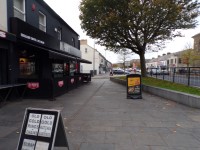
- The pathways on both sides are wide, however they do narrow slightly in some areas as you pass some shops and entrances.
- There are some uneven areas on the pathways throughout this section.
- There are some obstructions along the pavement on both sides such as signs, bins and signboards.
- There are some on street Blue Badge and standard parking bays available in Regents Street.
- This parking is free for 60 minutes, with no return within 1 hour.
Junction - Regents Street, Gibson Lane and Brewery Lane
- There is a crossing point over Regents Street, Gibson Lane and Brewery Lane.
- This pedestrian crossing has dropped kerbs, tactile paving on both sides and shows the green and red man symbol.
- The push button is 85cm high.
- The surface of the roads is tarmac.
- The surface of the pathways is a mixture of paving and block paving.
- Photographs 1, 2 and 3 show the pedestrian crossing next to Planet Bingo Ards on Regents Street.
- Photographs 4, 5 and 6 show the pedestrian crossing over Regents Street next to Milk Init.
- Photographs 7 and 8 show the pedestrian crossing over Gibson Lane.
Gibson Lane, Castle Place via Regents Street/Frances Street
- There are some uneven areas on the pathways throughout this section.
- There are some obstructions along the pavement on both sides such as signs, bins, cashpoints and signboards.
- These crossings have tactile paving and dropped kerbs on both sides.
- The surface of the road is tarmac at the crossing along Regents Street and Frances Street.
- There are some on street Blue Badge and standard parking bays available in Regents Street and Frances Street.
- These standard parking bays are free for 60 minutes, with no return within 1 hour.
- There is a pedestrian crossing next to the Newtownards Post Office and Ards Locksmith.
- Photograph 16 shows the pedestrian crossing.
- This pedestrian crossing has dropped kerbs, tactile paving on both sides and shows the green and red man symbols.
- The push button is 85cm high.
- The surface of the road is tarmac at this crossing.
- There is a pedestrian crossing next to Belvoir Estate Agents and The Jewel Box.
- Photographs 20, 21 and 22 show the pedestrian crossing.
- This pedestrian crossing has dropped kerbs, tactile paving on both sides and shows the green and red man symbols.
- The push button is 85cm high.
- The surface of the road is tarmac at this crossing.
Junction - Prices Lane, Frances Street and Castle Place
- There are several crossing points at this junction to cross Prices Lane, Frances Street and Castle Place.
- All crossings have dropped kerbs and tactile paving on both sides.
- The surface of the roads is tarmac.
- The surface of the pathways is tarmac.
- Photograph 1 shows the crossing on Prices Lanes and Frances Street.
- Photograph 2 and 3 shows the crossing on Frances Street and Castle Place.
- Photographs 7, 8 and 9 show there is an easy uphill slope running between Frances Street and High Street on Castle Place.
Junction - Castle Place, High Street and Movilla Street
- There are several crossing points at this junction to cross Castle Place, Movilla Street and High Street.
- All the crossings have dropped kerbs and tactile paving on both sides.
- The surface of the roads is tarmac.
- The surface of the pathways is paving.
- There is a pedestrian crossing on Castle Place and High Street.
- This pedestrian crossing has dropped kerbs, tactile paving on both sides and shows the green and red man symbols.
- The push button is 85cm high.
- The surface of the road is tarmac at this crossing.
- Photographs 2 and 3 show the pedestrian crossing.
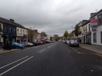
Castle Place, Mill Street via High Street
- The pathways on both sides of the road in this section are paving slabs and block paving.
- The pathways on both sides are wide, however they do narrow slightly as you pass some shops and signs.
- There is a pedestrian crossing next to the Danske Bank and GD1.
- This pedestrian crossing has dropped kerbs, tactile paving on both sides and shows the green and red man symbols.
- The push button is 85cm high.
- The surface of the road is tarmac at this crossing.
- Photographs 8, 10, 11 and 12 show the pedestrian crossing.
- There are some uneven areas on the pathways throughout this section.
- There are some obstructions along the pavement on both sides such as signs, cash points, bins and signboards.
- There is a pedestrian crossing next to Conway Square and Simon Brien Estate Agents.
- This pedestrian crossing has dropped kerbs, tactile paving on both sides and shows the green and red man symbols.
- The push button is 85cm high.
- The surface of the road is tarmac at this crossing.
- Photographs 13, 14 and 15 show the pedestrian crossing.
- There are some uneven areas on the pathways throughout this section.
- There are some obstructions along the pavement on both sides such as signs, cash points, bins and signboards.
- There are some standard parking bays available along the road.
- Blue Badge holders must have badges on display.
- These standard parking bays are free for 60 minutes, with no return within 1 hour.
Junction - Mills Street, Gibson Lane and John Street Lane
- There are several crossing points at this junction to cross Mill Street and John Street Lane.
- All the crossings have dropped kerbs and tactile paving on both sides with the exception to the crossing over Gibson Lane and Mill Street.
- The surface of the roads is tarmac.
- The surface of the pathways is paved.
- Photographs 3 and 4 show the crossing on John Street Lane.
Mills Street, Regents Street via Gibson Lane
- The pathways on both sides of the road in this section are formed of block paving.
- The pathways on both sides are wide, however they do narrow slightly as you pass some shops and signs.