Access Guide
Introduction
- The Harbour Loop is approximately a 2.5 mile walk around Bristol Harbour.
Brunel Square
- Turn right along the harbour walk from the SS Great Britain Public Car Park.
- The car park has Blue Badge marked bays.
- The car park is pay & display with reduced rates for SS Great Britain visitors.
- Parking is free for Blue Badge holders for up to 5 hours.
Wapping Wharf
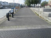
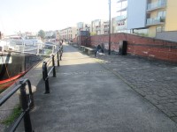
- This is an even concrete and block paved walk.
- The walk has seating available at the water's edge.
- The walk leads to Princes Wharf.
Prince's Wharf
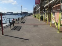
- On Prince's Wharf there is a level concrete surface where you have to repeatedly move over exposed crane tracks.
- This part of the walk leads to and passes the M Shed.
- Alternatively follow the cycle path here to avoid the crane tracks.
Wapping Road / Prince Street Bridge
- At the end of Prince's Wharf turn left and cross Prince Street Bridge.
- Keep to the left side of the bridge as there is a cycleway towards the middle and road traffic on the right-hand side.
- There is no physical separation between the cycleway and the pedestrian route.
- The surface here is tarmac.
- At the end of the bridge turn left and follow the harbour round to Pero's Bridge.
- The surface here is cobbled.
Pero's Bridge
- Enter onto Pero's Bridge (named after Pero Jones, brought to Bristol as a slave in 1783, who served the Pinney family close to this place until his death in 1798).
- Entry is between the 120cm wide bollards.
- The approach is cobbled block paving.
- Continue over the concrete surfaced bridge, which has handrails on both sides.
- The centre section of the bridge may be lifted to allow a larger vessel into the inner harbour.
- When the bridge is about to be opened it is closed off at both ends.
- At the far end of the bridge there is a 2cm gap onto the concourse and then a 20cm rain gulley.
Hanover Quay
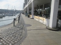
- Turn left along the even paved quayside.
- There is a cobbled surface and a barrier next to the water's edge.
- On the right is Millennium Square.
- Continue forward to the even tarmac Hanover Quay.
- The surface here has spaced cobbled strips interrupting the tarmac.
- There is a steep slope down to the even block paved amphitheatre and a steep slope up at the end of the amphitheatre.
- Continue the quayside walk along the chipping effect tarmac with the rumble cobble strips.
- There are seats and a barrier along the water's edge.
Alternative Route Avoiding Steps
- Take a right turn onto Cathedral Walk.
- Cathedral Walk is a minimum 3m wide block paved path with an easy slope.
- Take a left turn onto Canons Way.
- Canons Way is a block paved pavement.
- Take a left turn onto Anchor Road.
- Anchor Road is an even block paved pavement.
- Take another left on to Lime Kiln Road.
- Lime Kiln Road is a block paved pavement with a slight fall to the roadway.
- Lime Kiln Road passes over 2 easy slopes at 2 dropped kerbs.
- Take a left turn on to Gasworks Lane.
- Gasworks Lane is a cobbled lane with a block paved easy slope.
- Access to Gasworks Lane is reduced to 90cm due to upright bollards at the junction with Lime Kiln Road.
Signposted Harbourside Walk
- The walk is signposted past the end of Cathedral Walk and forward onto a long gentle sloping path towards Porto Quay.
- At the bottom of the path there is access to the gently sloping Millennium Promenade which re-joins Canons Way and Cathedral Walk.
- On Porto Quay there are a number of shops and restaurants.
- Follow the curve of the harbour to the left and there is a flight of steps up to the Gas Ferry North Quay and Gasworks Lane.
- There are 15+ steps with handrails on both sides.
- The steps have no contrast edges and are of medium depth.
- Alongside the steps is a platform lift, open for public use.
- The door of the lift is 89cm wide and the platform is 108cm wide by 146cm deep.
- There are separate entrance and exit doors and the controls are within easy reach.
- The controls have Braille and tactile markings.
- There is no voice or visual level display.
- On exiting the lift turn right and continue along Gas Ferry Wharf to Mardyke.
- If the lift is out of action (it is outdoors in a public place), it is approximately 40m to the Millennium Promenade which joins the section of the route avoiding steps.
Porto Quay
- Here is the uneven tarmac Porto Quay.
- The quay has a waterside barrier.
- Go forward onto the level concrete before climbing the concrete steep slope to the tree lined walk.
- Seating is available on the block paved walkway with rumble cobble strips and a viewing area.
- There is a clear view, across the river, of the SS Great Britain and frequent river traffic.
Western Wharf
- At this point there are 20 medium height steps down.
- The steps are not well marked and have handrails on both sides.
- The steps lead to Poole's Wharf Marina.
- There is a ramp from Porto Wharf, 160cm wide with handrails on both sides.
- The ramp overcomes the steps to Poole's Wharf Marina.
- There are 15+ medium, not well marked steps with handrails on both sides up to Mardyke Wharf.
- There is a platform lift to the right of the steps.
- The lift is 110 cm wide and 200cm deep.
- The door is 89cm wide and opens towards you as the lift arrives.
- The controls are 100cm high and are continuous push buttons.
- The doors are opposite each, other so the passenger does not have to turn. The lift is open for use at all times.
- The lift overcomes the steps.
Mardyke Wharf
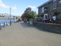
- There is an even straight small block paved walk with a barrier on the waterside.
- A slope leads up to the roadway and along the tree lined pavement slightly sloping towards the water.
- Continue through the Markyard Pay & Display Public Car Park which has 145cm wide bollards at each end.
- Continue past the car park down a steep slope and a quick left and right turn onto Poole Wharf.
Poole's Wharf
- The surface here is part block paved and part rubberised tarmac.
- There is a barrier and seating along the water's edge.
- There is a steep slope to the wooden boarded swing bridge.
- There is a steep slope down from the bridge to a tarmac with cobble rumble strips quayside walkway.
- Continue through the lock pathway, the path narrowing to a minimum of 155cm.
- Continue past the lock on a short concrete surface travelling over a number of manhole covers.
- Forward onto an even tarmac walk through the Pump House Car Park.
Cumberland Basin Bridge
- Turn left from the car park onto the tarmac pavement.
- Continue forward onto the Asphalt Bridge over a 4cm gap.
- Exit the bridge via an uneven, tarmac, easy sloped dropped kerb.
- Cross the tarmac Nova Scotia Place roadway.
- Up the uneven broken paved easy sloped dropped kerb to the tarmac pavement.
Underfall Boatyard
- Turn left to enter the Underfall Boatyard.
- Continue down a tarmac slope.
- Follow the uneven tarmac pathway crossing an 80cm wide wooden drainage channel and a 20cm wide traffic calming ramp.
Baltic Wharf
- Continue forward to the Baltic Wharf walkway from the Underfall Boatyard.
- Baltic Wharf is a block paved, even walkway with seating leading around the marina.
- At the end of the walkway you pass between 125cm wide bollards.
- There is a steep concrete slope leading to a slight tarmac slope.
- At the top of the slopes is a 97cm wide gap between bollards.
Banksy off Baltic Wharf
- The painting by Banksy known as 'The Girl with the Pierced Eardrum' is just off the Baltic Wharf car park to the right.
- As you follow the route you will see a building with a distinctive clock tower to your right.
- At the right-hand end of the building is an alleyway with the painting clearly visible at the end.
- Pass along the front of the building to follow the next section of the route.
Baltic Wharf - Brunel Square
- The Baltic Wharf Public Car Park and public toilets are here.
- Follow the tarmac road leading to the steep sloped Albion Dock.
- Turn left through 138cm wide bollards into an alley leading to Gas Ferry Road.
- At the bottom of Gas Ferry Road is Brunel Square.
- The SS Great Britain and car park are off Brunel Square.

