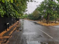
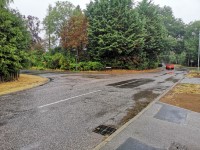
Access Guide
Introduction
- The following information describes the walking route from Hemingford Abbots to Hemingford Grey via the High Street and Manor Road. This route is approximately 0.8 miles long (1.4km).
- This route takes approximately 15 – 20 minutes on average depending on the speed you go.
- The route leads past several bus stops which are Church Lane, New Road and Oakfields.
- The surface of the pathways along the route is mainly tarmac.
- The pathway switches between the right and left hand side of the road multiple times along the route.
- The hazards on this route include; side roads, narrow pathways, slight and steep slopes, crossing points, and uneven pathways.
- The guide is split into the following sections:
- 1: Junction - Rideaway, High Street and Common Way
- 2: Rideaway to Church Lane via High Street
- 3: Junction - High Street and Church Lane
- 4: Church Lane to Manor Lane via High Street
- 5: Junction - High Street and Manor Lane
- 6: Manor Lane to Royal Oak Lane via High Street
- 7: Junction - Royal Oak Lane and High Street
- 8: Royal Oak Lane to Chapmans via High Street
- 9: Junction – High Street and Chapmans
- 10: Chapmans to Watts’ Lane/New Road via High Street
- 11: Junction - High Street and Watts’ Lane/New Road
- 12: Watts’ Lane/New Road to The Thorpe via High Street/Manor Road
- 13: Junction - The Thorpe and Manor Road
- 14: The Thorpe to Gore Tree Road/Braggs Lane via Manor Road
- 15: Junction – Manor Road and Gore Tree Road/Braggs Lane.
Getting Here
- By Car
- The walking route starts in Hemingford Abbots which is approximately 7.4 miles from the A1 at Huntingdon. The A1 has direct links to London to the south and the north via the A1(M).
- By Bus
- There are several stops on the High Street and Manor Way with direct links to Huntingdon, St Ives, and Godmanchester.
- For information on Dews Coaches see the following link:
- https://dews-coaches.com/local-bus-service.php
- By Train
- Huntingdon Train Station is approximately 3.9 miles from the north side of the route.
- Assistance at this station can be booked. Wheelchairs are available at this station but may only be available when the station is staffed.
- For more information on National Rail and Great Northern Rail please see the following links:
- https://www.nationalrail.co.uk/stations/hun/details.html
- https://www.greatnorthernrail.com/travel-information/plan-your-journey/station-information/stations/huntingdon.
Parking
- On Street Parking:
- There are no marked blue badge bays located on or near this route.
- There is on street parking situated at various points along the High Street, Manor Road, and other roads that line the route.
- Photographs 1 and 2 show the marked bays next to the Axe and Compass pub.
- Photographs 3 and 4 show on street parking located on the High Street near the junction with Manor Lane.
- Photographs 5 and 6 show marked bays on the High Street in between Manor Lane and Watts' Lane.
1: Junction - Rideaway, High Street and Common Way
- There are no crossings at this junction.
- The roadway has two way traffic.
- The roadway surface is tarmac.
- The pathway is on the right hand side coming out of Rideaway.
2: Rideaway to Church Lane via High Street
- The distance from Rideaway to Church Lane is approximately 98 metres.
- The pathway is tarmac and is undulated in places.
- There is a slight to steep uphill slope towards Church Lane.
3: Junction - High Street and Church Lane
- There are no crossings at this junction.
- There are dropped kerbs at this junction as shown in photograph 2.
- There is only a pathway on the right hand side of the roadway.
- The roadway surface is tarmac.
- Two way traffic flows in and out of Church Lane into the High Street.
4: Church Lane to Manor Lane via High Street
- The distance from Church Lane to Manor Lane is approximately 120 metres.
- The pathway is tarmac.
- The roadway is tarmac.
- There is on street parking on the left hand side of the roadway near Church Lane. There is also on street parking further along the roadway.
- There is a bus stop with bench seating by the junction with Church Lane.
5: Junction - High Street and Manor Lane
- There is a single crossing at this junction on the left hand side of the pathway.
- This crossing has a dropped kerb.
- The pathway is tarmac.
- The roadway is tarmac.
- The pathway continues along the right hand side of the pathway and disappears on the left hand side.
- Two way traffic comes in and out of Manor Lane into the High Street.
6: Manor Lane to Royal Oak Lane via High Street
- The distance from Manor Lane to Royal Oak Lane is approximately 50 metres.
- The surface of the pathway is tarmac.
- The surface of the roadway is tarmac.
- The pathway continues up to Royal Oak Lane where it finishes.
- To continue along the High Street use the dropped kerb as shown in photograph 5 and cross the road to the pathway on the left hand side. Use the dropped kerb as shown in photograph 7 to join the pathway on the left hand side of the road.
- Pedestrians will have to use the road for approximately 15 metres between the two dropped kerbs.
7: Junction - Royal Oak Lane and High Street
- There are no crossings at this junction.
- Traffic will only come out of Royal Oak Lane.
- The roadway is tarmac.
- The pathway is on the left hand side of the roadway leading towards Hemingford Grey.
8: Royal Oak Lane to Chapmans via High Street
- The distance from Royal Oak Lane to Chapmans is approximately 120m.
- The pathway is tarmac.
- The roadway is tarmac.
- The pathway is narrow in places (under 120cm) and undulated.
- There is a slight to steep uphill slope towards Chapmans.
- There is a marked parking bay on the left hand side of the roadway for approximately 6 cars.
9: Junction - High Street and Chapmans
- There is a single crossing at this junction with dropped kerbs.
- The pathway is tarmac.
- The roadway is tarmac.
- There is two way traffic flowing in and out of Chapmans into the High Street.
10: Chapmans to Watts’ Lane/New Road via High Street
- The distance from Chapmans to Watts’ Lane/New Road is approximately 200 metres.
- There is a slight to steep uphill slope towards Watts’ Lane/New Road.
- The pathway is tarmac.
- The roadway is tarmac.
- The pathway changes from the left hand side to the right hand side near the junction of Chapmans and the High Street.
- Photographs 2 and 3 show the dropped kerb on the left hand side of the roadway.
- Photographs 4 and 5 show the dropped kerb on the right hand side of the roadway.
- The pathway is undulated and has a slight to steep downhill as shown in photograph 11.
- There is a bus stop located on the left hand side of the roadway as shown in photographs 13 and 14.
- There is a dropped kerb at this bus stop. The stop itself is on a slight to steep slope.
11: Junction - High Street and Watts’ Lane/New Road
- This junction has a single crossing over New Road with dropped kerbs.
- The pathway is tarmac.
- The roadway on the High Street and New Road is tarmac.
- The roadway on Watts’ Lane is gravel.
- There is two way traffic flowing in and out of Watt’s Lane/New Road.
12: Watts’ Lane/New Road to The Thorpe via High Street/Manor Road
- The distance between Watts’ Lane/New Road and The Thorpe is approximately 500 metres.
- The pathway is tarmac.
- The roadway is tarmac.
- The pathway is narrow (under 120cm wide) and undulated in places.
- There is a slight to steep uphill slope towards The Thorpe.
- The pathway switches from the right hand side to the left hand side as shown in photographs 9 – 12.
- There are dropped kerbs at this crossing.
- There is two way traffic heading along the High Street at this crossing.
- The High Street turns into Manor Road at the sign for Hemingford Grey as shown in photograph 14.
13: Junction - The Thorpe and Manor Road
- There are no crossings at this junction.
- The roadway is tarmac.
- Two way traffic flows in and out of The Thorpe into Manor Road.
14: The Thorpe to Gore Tree Road/Braggs Lane via Manor Road
- The distance between The Thorpe and Gore Tree Road/Braggs Lane is approximately 290 metres.
- The pathway is tarmac.
- The roadway is tarmac.
- The pathway narrows (under 120cm wide) and is undulated at points.
- There are crossings along this part of the route that have dropped kerbs.
- There is a bus stop on this part of the route as shown in photographs 5 and 6.
- There is on street parking available on the part of the route.
15: Junction – Manor Road and Gore Tree Road/Braggs Lane
- There is a crossing at this junction.
- The crossing from Manor Road across Bragg’s Lane has tactile paving on both sides as shown in photographs 1 and 2.
- The pathway is tarmac.
- The roadway is tarmac.
- There is two way traffic flowing in and out of Manor Road and into Gore Tree Road/Braggs Lane.
Toilets
- There are no public toilets available but there is a pub (the Axe and Compass) and The Hemingford Pavilion that may allow you to use their facilities.


