Access Guide
Introduction
- The following information describes the route around Manea Pit starting and finishing at the West corner on Park Road.
- The route is detailed heading in an anti clockwise direction and is approximately 0.8 miles long.
- The route takes approximately 15 – 20 minutes to walk depending on the speed you go.
- The surface of the paths along the route consists of grass, wood chippings, gravel, loose chippings, and is undulated throughout.
- The potential hazards along the route include; steep and slight slopes, deep water, trip hazards and vehicles at the vehicular access point on the South corner.
- The guide is split into the following sections:
- - Access Point – West corner
- - West corner to South corner
- - Access Point – West corner to South corner
- - Access Point – South corner
- - South corner to East corner
- - Access Point – East corner
- - East corner to North corner
- - North corner to West corner.
Getting Here
- By Car
- The route is located on Park Road which is off Manea High Street approximately 5.0 miles from the A141. The A141 gives direct links to Huntingdon and the A1 to the south and to Wisbech and King’s Lynn to the north via the A47.
- By Bus
- The nearest bus station is Park Road which is located at the junction of the High Street and Park Road. The number 56 serves this route and gives links to Manea and Wisbech.
- For more information on Stagecoach buses please see the following link:
- https://www.stagecoachbus.com/
- By Train
- The nearest railway station is Manea (MNE) which is approximately 1.5 miles from the southern corner of the route. Manea Railway Station gives links to March and Ely. Assistance can be provided to get on and off the train by the onboard conductor. This station has step free access to both platforms.
- For more information on Manea railway station please see the following links:
- https://www.nationalrail.co.uk/stations-and-destinations/stations-made-easy/manea
- https://www.greateranglia.co.uk/travel-information/station-information/mne
- https://www.greateranglia.co.uk/accessibility.
Parking
- Public Car Parks
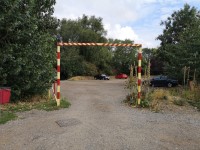
- There is an open air car park located on Park Road which leads to the West corner of the walk. There are no blue badge spaces and no marked standard spaces. The car park is free for all users.
- The car park surface is a mixture of soil, stones and loose chippings and is uneven throughout. There is a height restriction in place which is approximately 2.8metres as shown in photographs 1 - 4.
- There is another smaller car park with no height restriction located further down Park Road towards the East corner of the route as shown in photographs 5 - 7.
- There are two designated car park spaces located between the South and East corners next to the orchard. These spaces are accessed via a manual gate located at the South corner. A code for a padlock is required to access this gate (please contact the council).
Access Point (West Corner)
-
Access Point
View
- This information is for the access point located on the west corner.
- There is not an information board/map at this access point.
- There is ramped/sloped and stepped access at this access point.
- There is a gate which opens away from you (push).
- The gate is difficult to open.
- The gate has a latch lock.
- The width of the gap is 120cm.
-
Ramp/Slope
View
- The ramp/slope is located from the car park to the access point.
- The gradient of the ramp/slope is steep.
- The ramp/slope does not bypass the step(s).
-
Step(s)
View
- The step(s) is/are located in the gateway.
- There is/are 1 step(s).
- The step(s) is/are clearly marked.
- The height of the step(s) is/are not between 15cm and 18cm.
- The height of the step(s) is/are 12cm.
- The going of the step(s) is/are not between 30cm and 45cm.
- There is not a/are not handrail(s) at the step(s).
West Corner to South Corner
- This is the start of the route accessed from the car park. This part of the route is approximately 0.2miles long.
- There is a slight to steep slope going up along the first part of this section.
- The surface of the pathway here is soil, grass, and loose chippings.
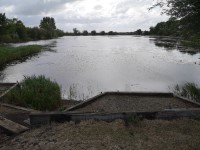
- There are 2 viewing areas along this part of the route. The furthest viewing area from the start on the section is accessible to a wheelchair user via a steep slope as shown in photographs 13 – 16.
- There are two seating areas available along this section as shown in photographs 7 and 8.
Access Point (West Corner to South Corner)
-
Access Point
View
- This information is for the access point located from the car park located along the west corner to south corner.
- There is an information board/map at this access point.
- There is step-free access at this access point.
- There is a gate which opens towards you (pull).
- The gate is easy to open.
- The gate has a sliding bolt lock.
- The width of the gap is 120cm.
-
Comments
View
- There is bench seating available at this access point.
Access Point (South Corner)
-
Access Point
View
- This information is for the access point located in the south corner of the route.
- There is not an information board/map at this access point.
- There is step-free access at this access point.
- There is a gate which opens towards you (pull).
- The gate is difficult to open.
- The gate has a sliding bolt lock.
- The width of the gap is 120cm.
- There are two identical access points here. Either can be used to avoid the narrow start of the South corner to East corner part of the route.
South Corner to East Corner
- This part of the route is approximately 0.2miles long.
- The first 8 metres of the route is very narrow (under 100cm wide) and undulated. Exiting via the access point and using the other access point to the left may be advisable.
- There is a slight to steep slope going up towards the east corner.
- The surface of the pathway is soil and grass for the initial 8 metres as shown in photographs 1 and 2. The rest of this section is hardcore with loose chippings until the east corner.
- There are multiple viewing areas along this part of the route accessed via slight to steep slopes as shown in photographs 7 - 10.
- There are two parking areas located on this section of the route as shown in photographs 11 and 12.
- There are two fixed wooden picnic tables, one either side of the orchard as shown in photographs 13 - 15.
Access Point (East Corner)
-
Access Point
View
- This information is for the access point located in the last corner of the route.
- There is not an information board/map at this access point.
- There is step-free access at this access point.
- There is a gate which opens towards you (pull).
- The gate is difficult to open.
- The gate has a sliding bolt lock.
- The width of the gap is 120cm.
East Corner to North Corner
- This part of the route is approximately 0.1miles long.
- The surface of the pathway here is gravel/loose chippings at the start and then grass for the rest of the section.
- There are two bollards on this route as shown in photograph 2. The gap between these bollards is more than 120cm.
- The section of the route is relatively level with little undulation.
- There are three viewing areas along this part of the route. All of the viewing areas are accessed via steps as shown in photographs 6 - 11
- There is fixed bench seating available on this section of the route as shown in photographs 6 and 7.
North Corner to West Corner
- This part of the route is approximately 0.3miles long.
- There are slight to steep slopes going both up and down along this section of the route.
- The surface of the pathway here is mainly soil, grass and some gravel/loose chippings in places.
- There are 2 viewing areas along this part of the route. There are steep slopes to access most of the viewing areas as shown in photographs 11 - 16.
- The decking area shown in photographs 11 and 12 is accessed via a step.
- There is fixed bench seating available as shown in photograph 17 and logs are used for seating as shown in photograph 18.


