
Access Guide
Introduction
- The total distance of the route is about 805 metres or 0.5miles. The total time the route should take to walk is about 10-12 minutes.
The route has several easy slopes and steep slopes. The pathway is wide in most parts but has some narrow sections.
There are some uneven surfaces due to uneven paving and raised manhole covers. There are several roads to cross with dropped kerbs and tactile paving. There is a mix of different crossings from zebra crossing, pedestrian crossing and just crossing.
There are several busy roads along the route. Some areas of the route may be congested.
There are some sections that are just pedestrianised and pass by busy buildings. - Related link National Express Coventry.
- Https://nxbus.co.uk/coventry/plan-your-journey
- Related link TheHub.
- Https://www.accessable.co.uk/coventry-university/access-guides/thehub
- Related link Engineering and Computing Building.
- Https://www.accessable.co.uk/coventry-university/access-guides/engineering-and-computing-building
Rachel Poole Bus Station
- The surface of the flooring within the bus station is block paving with tactile paths running throughout.
- There are sections of tactile path leading out of the bus station onto Fairfax Street.
- There are two exits here. One is a double set of automatic doors that open towards you and a single manual sliding door. Both have widths of over 150cm.
- There are toilets, shops and other facilities within the bus station.
Rachel Poole Meadow Bus Station Exit to Priory Street
- As you exit the bus station through the automatic double doors into Fairfax Street, the pathway is block paving with tactile paving until just after the exit. As shown in photograph 1.
- There is an easy slope downhill as you exit.
- On your right after about 13 metres you will see a zebra crossing to cross over Fairfax Street towards Priory Street as shown in photograph 2.
- This crossing has tactile paving and dropped kerbs on both sides with a small island in the middle which also has tactile paving and dropped kerbs. As shown in photographs 3, 4, 5 and 6.
- The path is block paving and changes to tarmac as you cross the crossing and then back to block paving as you reach the other side. The pathway is on an easy slope downhill.
- This is a two way road with heavy traffic in both directions.
- As you exit the crossing you will turn left towards Priory Street and continue ahead for about 18 metres along a pathway that is block paving and now level with some raised manhole covers along the pathway area. As shown in photographs 7, 8 and 9.
- You will now reach a crossing over Priory Street which has tactile paving and dropped kerbs. As shown in photographs 10, 11 and 12.
- The pathway is block paving and level with traffic coming from you right as you cross.
- The length to travel in this section is about 47 metres.
Priory Street to Priory Hall Coventry University Stepped Entry
- Turn right and continue along Priory Street along the pathway which is block paving and now a steep uphill slope.
- Continuing along the pathway for about 10 metres. The path narrows to 145cm as you pass a lamppost. As shown in photograph 2.
- The pathway is block paving and on a steep slope uphill.
- Continuing along Priory Street for about 20 metres, you will see the Priory Hall Coventry University building on your left. As shown in photograph 4.
- The stepped entrance to Priory Hall is directly off the pathway and has manual double doors to enter and 7 medium sized steps with a handrail on both sides to reach the entrance. As shown in photographs 4 and 5.
- The length to travel in this section is about 35 metres.
Priory Hall Coventry University Stepped Entry to Cope Street
- Continuing along Priory Street, the path is block paving with some uneven sections where some repair work has taken place. As shown in photographs 1 and 2.
- The pathway is block paving and on an easy slope uphill.
- After a further 45 metres you will reach the junction with Cope Street where there is an easy slope towards Cope Street. As shown in photographs 4 and 5.
- You will see Coventry University Student Union Building on your left. As shown in photograph 6.
- The length to travel in this section is about 52 metres.
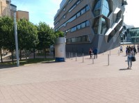
Cope Street to University Square/Alan Berry University Building
- Continuing along Priory Street the path is block paving with some uneven sections and becomes an easy slope uphill.
- After about 6 metres the path narrows to 145cm as you pass a tree with some uneven paving slabs as you pass. As shown in photograph 1.
- Continuing ahead for about 30 metres you will approach the Priory Hall Coventry University Building accessible entrance approach pathway on your left. As shown in photograph 3.
- You will see Coventry Cathedral to your right. As shown in photograph 5.
- The pathway is block paving and on an easy slope uphill.
- You will turn left passing the Priory Coventry University Building accessible entrance after about 16 metres with the Alan Berry University Building to your right and some fountains. As shown in photographs 6, 7, 8 and 9.
- The pathway is block paving and is uneven in several areas and has an easy slope downhill then an easy slope uphill as you turn right on the path towards Alan Berry University Building.
- Continue on the path towards the Alan Berry Building for about 19 metres then turn left with the Alan Berry Building to your right. As shown in photograph 11.
- For the Herbert Art Gallery and Museum University Building continue straight ahead and turn left. As shown in photograph 12.
- The length to travel in this section is about 110 metres.
University Square/Alan Berry University Building to TheHub
- Continue ahead with the Alan Berry University Building to your right.
- The pathway is now an easy downhill slope. As shown in photograph 1.
- The pathway is block paving with some uneven sections.
- As you continue ahead after about 18 metres you will see 7 steps to the right, that are of medium depth with a handrail on both sides to enter the Alan Berry Building if you wish. The automatic doors open towards you to enter. As shown in photographs 2 and 3.
- Continuing along the pathway which is still block paving and on an easy slope downhill, you will see the Charles Ward University Building to your left. As shown in photographs 5 and 6.
- Continuing ahead for about 30 metres the pathway becomes level and is still block paving with the option to turn left towards Charles Ward University Building or turn right towards the University Hub or straight ahead for George Eliot University Building. As shown in photographs 7 and 8.
- Continue right on the path with the Alan Berry University Building still to your right and the Charles Ward University Building behind you.
- As you continue ahead the pathway is still block paving, but the path becomes a steep slope downhill again. As shown in photograph 9.
- After 12 metres you will approach the Alan Berry University Building Entrance to your right with the Hub ahead. As shown in photographs 10 and 11.
- Continue ahead for 20 metres on a pathway that is level again now and is still block paving.
- Turn left and continue for a further 20 metres on a path that is block paving and level.
- TheHub is now on your right with automatic double doors that open towards you, using the touchpad that is 120cm in height. As shown in photographs 13 and 14.
- The George Eliot University Building is to your left opposite the Hub. As shown in photograph 15.
- The length to travel in this section is about 104 metres.
TheHub to Jordan Well
- Continue ahead on the pathway with TheHub to your right and George Eliot to your left.
- The pathway is block paving and level with some raised manhole covers and seating areas along the route. As shown in photographs 2, 3 and 4.
- Continue ahead on the path for about 27 metres and turn right with TheHub still to your right. The pathway is block paving and level.
- Continuing ahead you will pass some seating to your left, and after about 18 metres you will see another entrance into TheHub to your right, with manual and automatic double doors that open towards you. As shown in photograph 8.
- You will see Costcutter to your right as well which has a single automatic door to enter. As shown in photograph 9.
- You will now turn left now onto a ramp which bypasses the steps ahead. This ramp has an slight gradient uphill and is a concrete path with handrails on both sides and over 150cm in width. The ramp is about 29 metres in length. As shown in photographs 11, 12, 13 and 14.
- As you exit the ramp the path changes to block paving and becomes level as you reach Jordan Well.
- The length covered in this section is about 200 metres.
Jordan Well to Whitefriars Street
- Turn right and continue ahead with TheHub to your right on a path that is block paving and an easy slope uphill with some raised manhole covers along the pathway. As shown in photographs 1 and 2.
- After about 14 metres you will see a zebra crossing to cross Jordan Well. This crossing which has tactile paving and dropped kerbs. This crossing has traffic coming from both directions. As shown in photographs 3, 4, 5 and 6.
- Turn left as you exit the crossing with the Richard Crossman Building to your right. As shown in photograph 7.
- Continue ahead on a pathway that is block paving and now an easy downhill slope with some uneven sections. As shown in photograph 8.
- After about 5 metres you will see the Ellen Terry Building to your right. As shown in photograph 9.
- Continue ahead for a further 10 metres where you will see a crossing to your left to cross Jordan Well which has tactile paving and dropped kerbs. As shown in photograph 11.
- Just after this crossing you will arrive at Whitefriars Street with the Inkwell to your right. As shown in photographs 12. 13 and 14.
- The length covered in this section is about 60 metres.
Whitefriars Street to William Morris Building Gosford Street
- Continue ahead and cross Whitefriars Street using the crossing that has tactile paving and dropped kerbs. This road has traffic from both directions. As shown in photographs 1, 2, 3 and 4.
- The pathway is block paving and level.
- Continue ahead after crossing Whitefriars Street into Gosford Street passing the phoenix to the right. As shown in photograph 5.
- The pathway is block paving and is now an easy slope uphill again.
- Continuing ahead for about 25 metres and cross over a side road which has dropped kerbs and no tactile paving. As shown in photograph 7.
- On your left shortly afterwards there is a crossing to cross Gosford Street if you need to access that side of the road. This crossing has tactile paving and dropped kerbs and traffic comes from both directions. As shown in photograph 8.
- Continuing ahead, the pathway is still block paving but now becomes an easy downhill slope.
- You will approach another side road after about 17 metres. This doesn't have dropped kerbs or tactile paving as it is level with the path.
- This entrance gives access to a car park to the right. As shown in photographs 9 and 10.
- Continuing ahead you will pass under the ringroad and with the pathway still block paving and on an easy slope downhill. As shown in photographs 11 and 12.
- After about 50 metres you will reach the William Morris Building on Gosford Street.
- The length covered in this section is 325 metres.
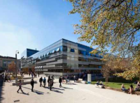
William Morris Building Gosford Street to ECB Main Access Way
- Turn right into the pedestrianised walkway passing some barriers which have a gap between them of over 150cm and go straight ahead. As shown in photographs 1 and 2.
- The pathway is block paving and on an easy slope uphill. With seating throughout the section.
- Continue ahead on the pathway that is block paving and on an easy uphill slope. You will pass Lancaster Library to the left. As shown in photograph 4.
- Continuing ahead for a further 70 metres the pathway is still block paving but is now an easy slope downhill and you will see the Engineering and Computing Building ahead.
- After a further 20metres you are at the entrance approach to Engineering and Computing Building in the ECB Main Access Way.
- The length covered in this section is about 150metres.