
Access Guide
Introduction
- The following information describes the route from Coventry Railway Station to Puma Way Junction.
The approximate distance of this route is 0,4 miles or 644metres.
The route takes approximately 8-12 minutes.
The route starts at the railway station doors through Station Square and along Park Street, passing Manor Road and using the Quinton Road Subway to cross a busy roadway. The route then continues along Mile Lane until reaching the end point at the junction with Merlin Close and Puma Way.
The pathways have a mixture of block paving and concrete throughout with most major crossings tarmac.
The potential hazards on this route include; narrow pathways in some sections, uneven paving, manhole covers, street signs, bollards, tree and steep/downhill and uphill slopes.
There are several crossings along the route with tactile paving and dropped kerbs.
The following University buildings are on this route directly:- Cu Mile Lane Building (opens 2019), HDTI Building, Elm Bank Building & NTDC Building. - The following University buildings are on Puma Way opposite the end of the route:-
Serious Games Institute Building, Innovation Village, Futures Institute Building, Design Hub Building, Enterprise Building, Innovation Centre Building, The Bistro and the Coventry Conferences Building. - Related link Coventry Railway Station.
- Http://www.nationalrail.co.uk/stations_destinations/COV.aspx
- Related link National Express Coventry.
- Https://nxbus.co.uk/coventry/plan-your-journey
Coventry Railway Station
- Coventry Railway Station is the main railway station serving the city of Coventry in the West Midlands, England. It is situated about 228 metres to the south of junction 6 of the inner ring road. The station is on West Coast Mainline (WCML) route between London and Glasgow, operated by Virgin West Coast and is at the centre of a junction where the lines to Nuneaton and to Leamington converge.
- Coventry station has regular services between London Euston and Birmingham New Street on the WCML. Other services are extended to/from Wolverhampton, Shrewsbury, Preston, Glasgow and Edinburgh Waverley. There are also long distance Cross-country services to Manchester to the north, and Oxford and Bournemouth to the south. Local services also operate between Coventry-Nuneaton, Northampton and Leamington Spa.
- For more information on services please use the following link:-http://www.nationalrail.co.uk/stations_destinations/COV.aspx
- There are four platforms available with step free access via lifts to all platforms.
- The station has the PlusBus scheme where train and bus tickets can be bought together at a saving.
- There are several bus stops available outside the railway station with services to Coventry City Centre & Bus Station, Leamington Spa and various other local services. These services are provided by National Express Coventry and some other local bus companies.
- For more information on National Express Coventry please use the following link:-https://nxbus.co.uk/coventry/
- There is also a taxi rank available directly opposite the railway station entrance.
- There is step free automatic double doors to enter the railway station.
- There are accessible toilet and standard toilet available within the station.
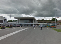
Coventry Railway Station Exit to Park Road
- There are automatic double sliding doors to exit the railway station onto Station Square as shown in photograph 1.
- As you exit through the doors from the station, the pathway is level and is block paving.
- After 7 metres you will approach a crossing with tactile paving on both sides and traffic coming from your right only, as shown in photographs 1, 2, 3 and 4.
- The paving changes to tarmac briefly as you cross the road and converts to concrete paving as you reach the other side.
- Continue straight ahead for 15 metres on a level concrete ground until you reach Park Road.
- The length covered in this section is about 35 metres.
Park Road to Manor Road
- Turn right onto Park Road where the path narrows to 70cm as you pass a bollard then increases back to over 150cm. As shown in photograph 1. The pathway in now block paving and on an easy uphill slope.
- You will pass some tactile pavement shown in photograph 2, which forms a crossing to cross Park Road.
- Continue along Park Road for about 50 metres until you reach the side entrance approach for Station Square, where you will find a manhole cover on the approach to the side entrance. Photograph 4 shows this.
- Cross this side entrance which has tactile paving on both sides and dropped kerbs with the path changing from block paving to concrete to tarmac and then back to concrete. As shown in photographs 5, 6 and 7.
- As you continue along Park Road after about 6 metres you will approach a service road for Park House. This crossing has dropped kerbs but no tactile paving. As shown in photographs 8 and 9. The pathway is still on an easy slope uphill and changes from block paving to tarmac and back again over the side entrance.
- As you continue ahead, the path narrows to 110cm to pass a tree after about 6 metres. The pathway become very uneven in this section. As shown in photographs 10 and 11.
- After a further 5 metres you will pass under a sign where the paths width is down to 137cm. As shown in photograph 12.
- After a further 7 metres you will pass another tree where the path narrows to 125cm and is very uneven. As shown in photograph 13.
- Continue straight ahead and you will approach Manor Road after about 10 metres.
- The length covered in this section of the route is about 116 metres.
Manor Road to Quinton Road Subway
- You will turn left over Park Road using the dropped kerbs on both sides that have no tactile paving. As shown in photographs 1, 2 and 3.
- Watching for the traffic in both directions, you will then cross over Manor Road using the dropped kerbs which do not have tactile paving. As shown in photographs 4, 5 and 6.
- The pathway changes from concrete to tarmac as you use the crossings.
- As you continue ahead, the pathway narrows after 4 metres to 120cm as you pass a tree and the path becomes uneven. As shown in photograph 7.
- Continuing ahead a further 7 metres the path narrows to 148cm as you pass a lamppost. The pathway is still concrete. As shown in photograph 8.
- Continuing ahead you will cross a side road after a further 4 metres which leads into Apps Living. As you cross the side road there is an easy slope towards the road leading from the side entrance. As shown in photographs 9, 10 and 11.
- Continuing ahead a further 6 metres the pathway narrows to 140cm as you pass a tree. There are several other trees in the pathway, similar along the route. As shown in photographs 12, 13, 14 and 15.
- Continuing ahead you will cross several driveways that have easy slopes towards the road. As shown in photographs 16 and 17. The pathway is now block paving again with some uneven sections.
- The length covered in this section of the route is about 0.1 miles or 161 metres.
Quinton Road Subway Crossing
- You will turn left off Park Road to the subway.
- There is a steep downhill slope with a handrail on the right as you progress along the subway. As shown in photographs 1 and 2.
- The pathway is block paving with some tactile paving throughout and some uneven sections.
- You will pass through a well lit tunnel. As shown in photographs 3, 4 and 5.
- The pathway is still block paving but becomes an easy slope uphill and then becomes steep as you reach the end of the tunnel section.
- As you exit the tunnel section the pathway is a steep slope that circles to the left then right with a handrail on the left. As shown in photographs 6, 7, 8 and 9. You will now exit onto Quinton Road.
- The length covered in this section of the route is about 0.1 miles or 161 metres.
Quinton Road to Mile Lane
- Turn left up a steep uphill slope on the pathway which is mainly block paving with some concrete patched sections and is uneven in places as the path circles to the left. As shown in photographs 1 and 2.
- Follow the path for about 19 metres and pass Listers Volkswagen on your right hand side. As shown in photographs 3 and 4.
- The pathway is still block paving with some sections that are concrete patches. As shown in photographs 7 and 8.
- There is some tactile paving throughout section as various parts.
- The length covered in this section of the route is about 32 metres.
Mile Lane to Elm Bank Car Park Entrance
- Continuing right into Mile Lane on an easy slope uphill on a pathway that is now concrete, passing Listers Volkswagen on your right. As shown in photographs 1 and 2.
- After about 8 metres you will reach a pedestrian crossing with tactile paving where the path narrows to 125cm in width as you pass the crossing. As shown in photographs 3, 4 and 5.
- Continuing ahead a further 16 metres you will cross a side road with dropped kerbs and no tactile paving with NTDC Coventry University on your left as you cross. As shown in photographs 6, 7 and 8.
- As you continue along Mile Lane for a further 12 metres you will see HDTI Coventry University on the left and the Elm Bank Coventry University approaching on your right. As shown in photographs 9, 10 and 11.
- Continuing along Mile Lane you will continue to pass Elm Bank Coventry University on your right for a further 14 metres on a pathway that is on an uphill steep slope with both concrete and block paving as a pathway.
- As you continue along Mile Lane a further 8 metres you will approach the entrance to Elm Bank Coventry University car park on your right. This entrance has a steep slope towards car park. As shown in photographs 13 and 14.
- You will see HDTI Coventry University on the left opposite. As shown in photograph 14.
- The Length covered in this section of the route is about 106 metres.
Elm Bank Car Park Entrance to Puma Way Junction
- Continuing ahead along Mile Lane, the pathway is concrete with an easy slope uphill.
- You will approach Cyril Maudslays Coventry University Building on your right after 10 metres and cross the quite side road entry to the car park to Cyril Maudslays. This crossing has an easy slope leading into the side road. As shown in photographs 2, 3 and 4.
- Continuing on a further 4 metres you approach a pedestrian crossing with tactile paving and dropped kerbs to cross Mile End Lane for Puma Way. As shown in Photographs 6 and 7. Use this crossing for Puma Way.
- Continuing ahead a further 10 metres you reach a crossing over Merlin Close which has tactile paving and dropped kerbs. As shown in photographs 8, 9 and 10. The path at this crossing changes from concrete to tarmac and then back to concrete as you reach the other side.
- The path is on an easy slope uphill.
- On your right after you have crossed the crossing there is a pathway leading to the CU Coventry Mile Lane new building. As shown in photographs 11, 12 and 13.
- As you look to your right you will see Puma Way. As shown in photograph 14.
- The length covered in this section of the route is about 91 metres.