
Access Guide
Introduction
- The route covers a distance of approximately 0.4 miles which should take approximately 8 minutes to complete.
- The surfaces along the route are block paving and tarmac.
- There are several busy roads along the route. .
- There are easy slopes along the route.
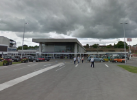
Coventry Railway Station
- Coventry Railway Station is the main railway station serving the city of Coventry in the West Midlands, England. It is situated about 228 metres to the south of junction 6 of the inner ring road. The station is on West Coast Mainline (WCML) route between London and Glasgow, operated by Virgin West Coast and is at the centre of a junction where the lines to Nuneaton and to Leamington converge.
- Coventry station has regular services between London Euston and Birmingham New Street on the WCML. Other services are extended to/from Wolverhampton, Shrewsbury, Preston, Glasgow and Edinburgh Waverley. There are also long distance Cross-country services to Manchester to the north, and Oxford and Bournemouth to the south. Local services also operate between Coventry-Nuneaton, Northampton and Leamington Spa.
- For more information on services please use the following link:-http://www.nationalrail.co.uk/stations_destinations/COV.aspx
- There are four platforms available with step free access via lifts to all platforms.
- The station has the PlusBus scheme where train and bus tickets can be bought together at a saving.
- There are several bus stops available outside the railway station with services to Coventry City Centre & Bus Station, Leamington Spa and various other local services. These services are provided by National Express Coventry and some other local bus companies.
- For more information on National Express Coventry please use the following link:-https://nxbus.co.uk/coventry/
- There is also a taxi rank available directly opposite the railway station entrance.
- There is step free automatic double doors to enter the railway station.
- There are accessible toilet and standard toilet available within the station.
Manor Road to Quinton Road Subway
- You will turn left over Park Road using the dropped kerbs on both sides that have no tactile paving. As shown in photographs 1, 2 and 3.
- Watching for the traffic in both directions, you will then cross over Manor Road using the dropped kerbs which do not have tactile paving. As shown in photographs 4, 5 and 6.
- The pathway changes from concrete to tarmac as you use the crossings.
- As you continue ahead, the pathway narrows after 4 metres to 120cm as you pass a tree and the path becomes uneven. As shown in photograph 7.
- Continuing ahead a further 7 metres the path narrows to 148cm as you pass a lamppost. The pathway is still concrete. As shown in photograph 8.
- Continuing ahead you will cross a side road after a further 4 metres which leads into Apps Living. As you cross the side road there is an easy slope towards the road leading from the side entrance. As shown in photographs 9, 10 and 11.
- Continuing ahead a further 6 metres the pathway narrows to 140cm as you pass a tree. There are several other trees in the pathway, similar along the route. As shown in photographs 12, 13, 14 and 15.
- Continuing ahead you will cross several driveways that have easy slopes towards the road. As shown in photographs 16 and 17. The pathway is now block paving again with some uneven sections.
- The length covered in this section of the route is about 0.1 miles or 161 metres.
Coventry Railway Station Exit to Park Road
- There are automatic double sliding doors to exit the railway station onto Station Square as shown in photograph 1.
- As you exit through the doors from the station, the pathway is level and is block paving.
- After 7 metres you will approach a crossing with tactile paving on both sides and traffic coming from your right only, as shown in photographs 1, 2, 3 and 4.
- The paving changes to tarmac briefly as you cross the road and converts to concrete paving as you reach the other side.
- Continue straight ahead for 15 metres on a level concrete ground until you reach Park Road.
- The length covered in this section is about 35 metres.
Park Road to Manor Road
- Turn right onto Park Road where the path narrows to 70cm as you pass a bollard then increases back to over 150cm. As shown in photograph 1. The pathway in now block paving and on an easy uphill slope.
- You will pass some tactile pavement shown in photograph 2, which forms a crossing to cross Park Road.
- Continue along Park Road for about 50 metres until you reach the side entrance approach for Station Square, where you will find a manhole cover on the approach to the side entrance. Photograph 4 shows this.
- Cross this side entrance which has tactile paving on both sides and dropped kerbs with the path changing from block paving to concrete to tarmac and then back to concrete. As shown in photographs 5, 6 and 7.
- As you continue along Park Road after about 6 metres you will approach a service road for Park House. This crossing has dropped kerbs but no tactile paving. As shown in photographs 8 and 9. The pathway is still on an easy slope uphill and changes from block paving to tarmac and back again over the side entrance.
- As you continue ahead, the path narrows to 110cm to pass a tree after about 6 metres. The pathway become very uneven in this section. As shown in photographs 10 and 11.
- After a further 5 metres you will pass under a sign where the paths width is down to 137cm. As shown in photograph 12.
- After a further 7 metres you will pass another tree where the path narrows to 125cm and is very uneven. As shown in photograph 13.
- Continue straight ahead and you will approach Manor Road after about 10 metres.
- The length covered in this section of the route is about 116 metres.
Park Road to Little Park Street (Via Subway)
- Head down the steep ramp to the subway which can be seen in photograph 1. The ramp has a handrail to the right as you head down and a surface of block paving.
- As you head into the subway tunnel shown in photographs 2 and 3, there is a slight uphill gradient. The exit to the tunnel is shown in photograph 4.
- Upon exiting the tunnel turn left. Head through the subway tunnel shown in photographs 5 and 6.
- Upon exiting, there is a steep slope which has a handrail to your right which can be seen in photograph 7.
- As you continue you will see the Martyr's Field Memorial to your left this can be seen in photograph 8.
- Continue forward and cross the bridge shown in photograph 9.
- Turn right and head down the steep ramp which has a handrail to your right. This can be seen in photographs 10 and 11.
- At the bottom of the slope turn right and head through the subway which has a slight upward gradient. This can be seen in photograph 12.
- As you exit the subway onto Little Part Street there is a steep upward slope with a handrail to the left going up. The slope is block paving with sections of guttering and the odd section of tactile paving.
- The slope can be seen in photographs 13 and 14
- This covers a distance of 170m.
Little Park Street Subway Exit to St John's Street
- After exiting the subway continue forward along Little Park Street. The surface of the pavement is block paving and can be seen in photograph 1.
- After 35m there is a tarmac service road to access Coventry Police Station, which has drop kerbs on either side of the road. This can be seen in photographs 2 and 3.
- On the other side of the road the surface becomes tarmac with occasional block paving before becoming simply block paving. This can be seen in photograph 4.
- There is a section blocked paving which features some tactile paving for a zebra crossing you will need to continue past this along Little Park Street at this point. The paving can be seen in photograph 5.
- Approximately 8m after the tactile paving there is a tarmac service road into a car park. This can be seen in photograph 6.
- Continue onwards for an additional 40m until you reach the St John's Street Crossing. The pavement for this area is tarmac and can be seen in photographs 7 and 8.
- The distance of this section is approximately 120m.
Earl Street to Much Park Street
- Turn right and head down Earl Street until you reach Much Park Street and then cross it a distance of 130m.
- There are two slopes as you turn right down Earl Street these can be seen in photographs 1 and 2.
- As you continue down Earl Street there is a noticeable downhill gradient.
- The surface of the pavement is uneven block paving with the occasional manhole cover.
- The area is also cloistered until just before you reach Much Park Street.
- This can be seen in photographs 3, 4 and 5 with the non cloistered area shown in photograph 6.
- Cross Much Park Street at the pedestrian crossing which has tactile drop kerbs on either side, is tarmac and has traffic approaching from both directions. The crossing can be seen in photographs 7 and 8.
- After crossing the road turn right along Much Park Street to reach the main entrance to the Whitefriars Building.
- To reach the Alison Gingell Building you will need to continue forward.
Much Park Street to Whitefriars Street
- After the Much Park Street crossing continue down Earl Street until you reach Whitefriars. To your right along this section of Earl Street is the Richard Crossman and the Ellen Terry Buildings.
- The surface of the pavement is uneven block paving with the occasional manhole cover.
- The pavement also has a downhill gradient.
- After approximately 15m from Much Park Street there are several trees along the pavement which may prove to be obstacles. This continues for approximately 40m. This can be seen in photographs 2 and 3.
- After this there is a section of tactile paving for a zebra crossing which can be seen in photograph 4. The crossing leads to TheHub and University Square area.
- Continue on until you reach Whitefriars this can be seen in photographs 5, 6 and 7.
- The total distance of this section is 130m.
St John's Street to Earl Street (Via Little Park Street)
- On crossing St John's Street head forward and continue until you reach Earl Street.
- The surface of the pavement is block paving with the occasional manhole cover. As can be seen in photographs 1, 2 and 3.
- Head along Little Park Street and continue along pavement you will encounter tactile paving for a zebra crossing photograph 4.
- As you approach Earl Street you will encounter two easy slopes with paved surfaces and no handrails which can be seen in photographs 5 and 6.
- At the top of the second slope turn right and head along Earl Street. This can be seen in photograph 7.
- The distance for the area is approximately 150m.
Whitefriars Street to Alison Gingell/Sports Centre
- Turn right into Whitefriars Street and continue straight ahead.
- The pathway changes now from block paving to concrete and is on an easy uphill slope. As shown in photograph 1.
- Continuing along the path for around 12 metres, the path narrows to 140cm as you pass a pay and display payment machine on your right and then shortly after a lamppost to your left. As shown in photograph 2.
- After a further few metres you will pass the Student Engagement Centre (Whitefriars Building) on your right. As shown in photographs 3 and 4.
- The pathway is still concrete and on an easy slope uphill and there are several sections that are uneven.
- There are several raised manhole covers and uneven sections of pathway throughout. As shown in photographs 5 and 7.
- Continuing ahead a further 17 metres you will see the Alison Gingell/Sport Centre on your right ahead.
- The pathway now becomes part concrete part block paving and is still on an easy slope uphill. As shown in photographs 6 and 7.
- You will now follow the block paving part of the path (to the right side) where it narrows to 110cm in width as the paths go their different ways. As shown in photographs 8 and 9.
- Follow the path for about 18 metres and you will reach the Alison Gingell/Sport Centre ahead. The entrance has an automatic single opening door towards you and a revolving door also. As shown in photograph 10.
- The length covered in this section is about 72metres.