
Access Guide
Route Information
- This route goes from L'eree Bay Headland to the Loop-Holed Tower at Vazon Bay.
- The majority of the route is on surfaced paths.
- Some of the route involves walking on some Ruette Tranquilles. There are no footpaths along these road.
- The speed limit on the the Ruette Tranquilles is 15mph with priority given to walkers, cyclists and horse riders.
- The route will take approximately 2.5 hours.
- This route is not a loop so you may need to retrace the route to return to the car parking at L'eree Bay Headland.
- There is car parking available at L'eree Bay Headland and along Vazon Bay. These can be used as pickup and drop off points.
- Alternatively there are bus stops near L'eree Bay Headland and along Vazon Bay.
- There are a number of additional car parks located along the route, which can be used to make the walk more manageable for people with limited mobility.
- There are public toilets located at L’eree Bay Beach and along Vazon bay. These may only be open during peak season.
- For more information about the walk, to download a map or an audio information podcast please click here (opens in a new tab).
L'eree Bay Headland - L'eree Bay Shingle Bank
- This section of the walk is approximately 320m.
- The walks begins at L'eree Bay Headland.
- There is a car park located at the end of the headland.
- The headland has views of L'eree bay and Lihou Island.
- There is tarmac road leading from the car park.
- There may be vehicles using the road, caution is advised.
- There is a steep slope leading down from the headland to L'eree Bay Shingle Bank.
- If the road down is not accessible there is a car park located next to the Shingle Bank.
L'eree Bay Shingle Bank - Perelle Bay
- This section of the walk is approximately 614m.
- There is car parking available next to L'eree bay Shingle Bank.
- The car park has an uneven surface.
- There is a path that runs parallel to the shingle bank and La Route De La Roque.
- The path has a loose chipping surface.
- The Colin Best Nature Reserve is located on the opposite side of La Route De La Roque.
- There are easy and moderate slopes along the route.
- The path merges with the footpath for La Route De La Roque.
- The surface of the footpath is tarmac.
- At the point La Route De La Roque bears right, there is a small parking area.
- The parking overlooks Perelle Bay.
Perelle Bay - Perelle Village
- This section of the walk is approximately 840m.
- From the parking the route requires crossing La Route De La Roque.
- There is no designated crossing point on the road so caution is advised when crossing.
- There is a path that runs off La Route De La Roque.
- The surface of the path begins as tarmac and becomes loose chipping as you reach the end of the path.
- The path is uneven in places.
- At the end of the path it merges with a Rue De Tranquil. At the Rue De Tranquil turn left and follow the road.
- There is no footpath along the road.
- The surface of the road is tarmac and narrow in places, so be wary of passing vehicles.
- The are easy and moderate slopes along the road.
- Follow the Ruette Tranquilles until it reaches the cross road with the Rue De Felconte.
- Rue De Felconte leads into Perrelle Village.
Perelle Village - Vazon Bay
- This section of the walk is approximately 3km long.
- At the crossroads turn left and follow the road until it bears right and becomes La Grande Rue.
- Along the La Grande Rue there is a footpath beside the road.
- The footpath is tarmac and is step free.
- Along the La Grande Rue there is St Apolline's Chapel.
- At the chapel turn left and follow the side road for 100m.
- There is no footpath along the side road.
- At the crossroad take a right and carry on following the road for 400m until you reach a cross road with the La Grand Rue.
- Turn Left and follow La Grand Rue for 210m until you reach a crossroad.
- At the crossroads turn left and then take the next first right turn.
- Follow the road for 170m until you reach a crossroads with Rue De La Maladrerie.
- Cross over Rue De La Maladrerie to access Route De La Marette.
- There is no designated crossing point on the road.
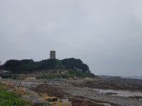
- Follow Route De La Marette for 450m until the road reaches a car park and Fort Richmond.
- Fort Richmond overlooks both Perelle Bay and Vazon Bay.
- After visiting Fort Richmond, return up Route De La Marette.
- When you reach the crossroads with Rue De La Maladrerie, turn left and follow the road for 60m and take the first left.
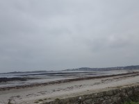
- Follow the road for 400m until you reach Vazon Bay.
- After 200m the road bears right and leads to the parking at Vazon Bay.
Vazon Bay - Loop - Holed Tower
- This section of the walk is approximately 1.5km long.
- There is car parking available at the Perelle Village end of Vazon bay.
- There is a path leading from the car park.
- The path has loose chippings, but as you progress along the path some parts have a light sandy surface.
- There are easy and moderate slopes along the path.
- There is another car park located along Vazon Road. There is the Richmond Kiosk which sells hot and cold snacks (the kiosk is only open during peak season).
- The car park is split into two.
- There is a steep sandy slope leading between the two car parks.
- There is a toilet block located between the two car parks (the public toilet is only open during the peak season).
- The path resumes after the car parking.
- The path has a loose chipping surface and is uneven in places.
- At the end of the path there is another car park available.
- The path carries on the opposite side of Vazon Road.
- There is no designated crossing point.
- There is a tarmac footpath running alongside Vazon Road.
- The route crosses Vazon Road again and carries on a footpath.
- The footpath is tarmac and leads to the Loop Holed Tower.
- There is a restaurant, public toilets and parking located near to the tower.
- For more information about Vistas Cafe and Public Toilets please click here (opens in a new tab).