
Access Guide
Introduction
- Related link Albion Road Multi-storey Car Park.
- Https://www.accessable.co.uk/london-borough-of-bexley/access-guides/albion-road-multi-storey-car-park
- Related link Bexley Civic Offices.
- Https://www.accessable.co.uk/london-borough-of-bexley/access-guides/london-borough-of-bexley-civic-offices
-
Comments
View
- This guide describes a step-free walking route between the Albion Road car park and the Civic Offices.
- The route is approximately 200m long.
- It should take approximately 5 minutes to walk.
- If you have difficulty getting around it could take 10 minutes.
- There are two main roads to cross.
- Both have pedestrian crossings.
Albion Road Car Park Pedestrian Exit
- The exit is located at the front of the multi-storey car park on Albion Road.
- At time of visit (September 2023) the car park lift was out of use and there was no information regarding when it would be repaired.
- Without the lift, access from the public levels of the car park on level 3 upwards, including the Blue Badge bays, is by stairs only.
- There is a single, manual, heavy door with a locked extension leaf to exit the car park. It is permanently held open, opens away from you (push) when exiting the building, and is 85cm wide.
Leave the Car Park by the Albion Road Exit
- On leaving the car park, there is a short path with a steep slope down onto Albion Road and this does not have handrails.
- After 5m the path meets the pavement.
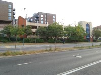
- Turn left onto Albion Road.
Continue Along Albion Road
- The pavement is level in this area.
- Look out for signposts in the pavement.
- After 50m, there is tactile paving to mark the approach to the roundabout.
- The cycle lane ends here and bicycles ride onto the pavement.
- 10m after this, there is tactile paving to mark a pedestrian crossing to the right.
- Ignore this and continue as the pavement curves round to the left and into Gravel Hill.
- The pavement has a slight uphill slope.
Follow the Pavement Round the Curve
- The Marriot Hotel is on your left.
- There is a long slight slope up on the pavement.
- There is tactile paving to indicate a pedestrian crossing.
- Do not cross here.
- There is tactile paving after the crossing to indicate that cycles should re-join the cycle path in the road.
- Continue up the slope.
- You will see the Civic Offices ahead.
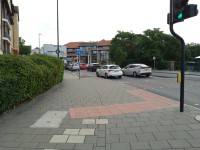
Continue Ahead Towards the Pedestrian Crossing
- At the top of the slope, there is a broad paved area which is shared with cycles.
- There is red tactile paving to indicate a pedestrian crossing to the right.
- Ignore this and continue ahead to a second band of tactile paving.
- This leads to the pedestrian crossing on The Broadway.
- The crossing is in two sections, with an offset central refuge.
- The second crossing is to the left as you cross onto the central refuge.
- There are flush kerbs marked by tactile paving in all locations.
- Each section has its own push buttons for the crossing, with a rotating cone for visually impaired users.
- The crossing has a visible red lamp around the push button which illuminates when the button is pressed and goes out when it is safe to cross. However the crossing does not have audible beeps.
- At traffic light level, there is a red and green man, as well as a countdown timer indicating how long you have left to cross.
- On the far side of the road, turn right to pass the Prince Albert pub.
Continue Ahead Past the Prince Albert Public House
- The pub has some external seating to your left.
- There is a Legible London map sign to your right.
- The Civic Offices can be seen ahead.
- Follow the pavement round to the left into Woolwich Road.
- Continue until the red tactile paving marking the pedestrian crossing to your right.
Cross Woolwich Road at the Pedestrian Crossing
- The crossing is in two sections with a refuge in the middle.
- There are flush kerbs with tactile paving at the crossing and at the refuge.
- Each section is controlled by separate push buttons and lights.
- There are rotating cones for visually impaired users on the crossing controls.
- The crossing has a visible red lamp around the push button which illuminates when the button is pressed and goes out when it is safe to cross. However the crossing does not have audible beeps.
- At traffic light level, there is a red and green man, as well as a countdown timer indicating how long you have left to cross.
For the Entrance Ramp, Turn Left After the Crossing
- Continue along Woolwich Road with the Civic Centre on your right.
- There is a band of tactile paving to mark the end of the area shared with cyclists.
- Turn right here, round the end of the concrete wall.
Civic Office Entrance Ramp
- The ramp has a long slight gradient.
- It is approximately 15m long, with a landing halfway up.
- The ramp does not have handrails.
- There is a large level area at the top of the ramp.
Civic Offices
- Turn left at the top of the ramp.
- The double doors open automatically.
- You have arrived at the Civic Offices.