
Access Guide
Introduction
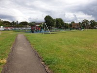
- Services / facilities within the grounds include a children's play area, outdoor gym and a basketball area.
Location
- There is not a bus stop within 150m (164yds) of the venue.
- The nearest National Rail station is Northolt Park.
- The nearest underground station is Ruislip Gardens.
Opening Times
- The venue is open 24hrs.
Parking
- The venue does have its own car park.
-
Venue Car Park
View
- Parking is free for all users.
- The car park is located off Priors Gardens.
- The car park type is open air/surface.
- There is/are 0 Blue Badge parking bay(s) within the car park.
- The route from the car park to the entrance is accessible to a wheelchair user with assistance.
- Assistance may be required because there is/are loose chippings.
- The car park surface is loose chippings.
- There is not a road to cross between the car park and the entrance.
- The car park does not have a height restriction barrier.
-
Drop-off Point
View
- There is not a designated drop off point.
Vehicle Entrance and Exit
- The vehicle entrance and exit is located off Priors Gardens.
- There is no height restriction barriers or gates to enter the area.
- There are no designated pedestrian footpaths/pathways from this entrance to the park.
Access Point (Car Park)
-
Access Point
View
- This information is for the access point located in the parking area.
- There is not an information board/map at this access point.
- There is step-free access at this access point.
- There is a gate which opens away from you (push).
- The gate is permanently held open.
- The width of the gap is 125cm.
- There are uneven surfaces leading to the access point.
Access Point (Cedar Avenue)
-
Access Point
View
- This information is for the access point located at the end of Cedar Avenue.
- There is not an information board/map at this access point.
- There is ramped/sloped or stepped access at this access point.
- There is a gate which opens away from you (push).
- The gate is permanently held open.
- The width of the gap is 130cm.
- There are uneven surfaces on the pathway leading to the gate.
-
Ramp/Slope
View
- The ramp/slope is located on the pathway leading to the gate.
- The gradient of the ramp/slope is steep.
- The ramp/slope does bypass the step(s).
-
Step(s)
View
- The step(s) is/are located leading to the gate.
- There is/are 1 step(s).
- The step(s) is/are not clearly marked.
- The height of the step(s) is/are not between 15cm and 18cm.
- The height of the step(s) is/are 5cm.
-
Comments
View
- There is a dropped kerb here.
- The surface of the pathway here is uneven.
Access Point (Masson Avenue)
-
Access Point
View
- This information is for the access point located at the end of Masson Avenue.
- There is not an information board/map at this access point.
- There is step-free access at this access point.
- There is a gate which opens away from you (push).
- The gate is permanently held open.
- The width of the gap is 125cm.
-
Comments
View
- There is a dropped kerb on the left before the gate.
- The surface of the pathway here is uneven.
Access Point (Walnut Way)
-
Access Point
View
- This information is for the access point located at the end of Walnut Way.
- There is not an information board/map at this access point.
- There is step-free access at this access point.
- There is a gate which opens away from you (push).
- The gate is permanently held open.
- The width of the gap is 130cm.
-
Comments
View
- The surface of the pathway here is uneven.
Access Point (Nairn Road)
-
Access Point
View
- This information is for the access point located at the end of Nairn Road.
- There is not an information board/map at this access point.
- There is step-free access at this access point.
- There is a gate which opens away from you (push).
- The gate is permanently held open.
- The width of the gap is 125cm.
-
Comments
View
- There is a dropped kerb on the right before the gate.
- The surface of the pathway here is uneven.
- There is a cycle stand at the front of the gate.
- The width on the left side of the cycle stand is 90cm and right side is 80cm.
Access Point (Frazer Avenue)
-
Access Point
View
- This information is for the access point located at the end of Frazer Avenue.
- There is not an information board/map at this access point.
- There is ramped/sloped access at this access point.
- There is a gate which opens away from you (push).
- The gate is permanently held open.
- The width of the gap is 125cm.
-
Ramp/Slope
View
- The gradient of the ramp/slope is slight.
-
Comments
View
- The surface of the pathway here is uneven.
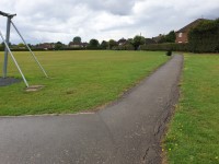
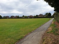
Parks and Gardens
- The park or garden does have footpaths.
- The path(s) has a / have tarmac surface(s).
- The majority of the path(s) is / are wide enough for wheelchair users.
- There are slight slopes on the paths.
- There are bench seats situated along the paths for people to rest.
Children's Play Area
- The play area is located to the left, beyond the Priors Gardens access point.
- A climbing frame, seesaw, swings, slides and a zip line are available.
- There is level access throughout area.
Accessible Toilet
- Accessible toilet facilities are not available.
Standard Toilet(s)
-
Availability and Location of Standard Toilets
View
- Standard toilet facilities are not available.