Access Guide
Introduction
- Barnes High Street is located along the A3003, north-east of the borough.
It is centred 5.3 miles south-west of Charing Cross in a bend of the River Thames.
This guide covers the main shopping area of the High Street.
This runs from Station Road in the east to Terrace Gardens in the west.
This is approximately 0.3 miles (482m) long and takes around 5 minutes to walk.
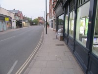
The shopping area is generally level.
Footpaths are of concrete paving slabs.
The road surfaces are tarmac with tactile paving at the majority of crossing points.
.
Getting Here
- By Car:
- Barnes High Street is located approximately 1 mile from the A205, using Priests Bridge, White Hart Lane and The Terrace from the west or Rocks Lane, Mil Hill Road and Station Road from the east.
- Barnes High Street runs from west to east.
- At the west end it joins with The Terrace and Lonsdale Road.
- At the east end it joins with Church Road and Station Road.
- Parking:
- There is limited on-street parking.
- By Bus:
- There is a bus stop on the south side of Barnes High Street which serves many routes to the surrounding areas.
- By Train:
- Barnes Bridge Station is located to the south of Barnes High Street on The Terrace.
- There is not step-free access to the platforms at this station.
Parking
- On-Street Parking:
- There are no on-street Blue Badge bays available along Barnes High Street.
- There are plenty of standard on-street bays on both sides of Barnes High Street and along Station Road.
- There are no dropped kerbs from the bays to the pavement.
Barnes High Street South - Station Road to Terrace Gardens
- The footpaths are generally level with some slight slopes close to the road.
- There may be tables and chairs on the pavement outside cafés.
- There are parking meters, cycle racks and poles for road signs set into the pavement.
- There may also be A-board signs outside shops.
- There is a bus stop outside Jigsaw.
Crossing Point - Essex Court
- The crossing at Essex Court has dropped kerbs but no tactile paving.
- The surface of the pavement is concrete slabs.
- The surface of the road is tarmac.
Crossing Point - Stanton Road
- The crossing at Stanton Road has dropped kerbs but no tactile paving.
- The surface of the pavement is concrete slabs.
- The surface of the road is block paving.
Controlled Crossing Point near to Stanton Road
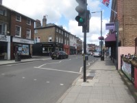
- There is a push button pedestrian crossing with visual signals.
- The right-hand push button is fitted with a rotating cone for visually impaired users.
- There are dropped kerbs and tactile paving on both sides of the road at this crossing.
Crossing Point - Terrace Gardens
- The crossing at Essex Court has dropped kerbs but no tactile paving.
- The surface of the pavement is concrete slabs.
- The surface of the road is tarmac.
Crossing Point near to Terrace Gardens
- There is a zebra crossing near to Terrace Gardens.
- There are dropped kerbs and tactile paving on both sides of the road at this crossing.
Barnes High Street North - Lonsdale Road to Station Road
- The footpaths are generally level with some slight slopes close to the road.
- There may be tables and chairs on the pavement outside cafés.
- There are parking meters, bollards and poles for road signs set into the pavement.
- There may also be A-board signs outside shops.
Crossing Point - St Anns Road
- The crossing at St Anns Road has dropped kerbs and tactile paving.
- The surface of the pavement is concrete slabs.
- The surface of the road is tarmac and block paving.
Controlled Crossing Point near to St Anns Road
- There is a push button pedestrian crossing with visual signals.
- The right-hand push button is fitted with a rotating cone for visually impaired users.
- There are dropped kerbs and tactile paving on both sides of the road at this crossing.
Crossing Point - Swan Place
- The crossing at Swan Place has dropped kerbs but no tactile paving.
- The surface of the pavement is concrete slabs.
- The surface of the road is tarmac.
Crossing Point - Church Road
- There is a pedestrian crossing with traffic island, tactile paving and dropped kerbs on both sides of the road.
Access Guides Available For (Barnes Shopping Area)
-
Shopping
View
- Pets Corner London - To view the access guide please click here (new tab).
- Jigsaw - To view the access guide please click here (new tab).
- Sainsbury's Local - To view the access guide please click here (new tab).
- Marks and Spencer Barnes Simply Food - To view the access guide please click here (new tab).
- Octavia Foundation - To view the access guide please click here (new tab).
- James Anderson Sales - To view the access guide please click here (new tab).
- James Anderson Lettings - To view the access guide please click here (new tab).
- Savills - To view the access guide please click here (new tab).
- Barnes Pharmacy - To view the access guide please click here (new tab).
- The Real Cheese Shop - To view the access guide please click here (new tab).
- Dilli Grey & Friends - To view the access guide please click here (new tab).
- Timpson - To view the access guide please click here (new tab).
- Classy Cleaners - To view the access guide please click here (new tab).
- Totally Swedish - To view the access guide please click here (new tab).
- Chestertons - To view the access guide please click here (new tab).
- Barnes Jewellery - To view the access guide please click here (new tab).
- Eating and Drinking View
- Other Services View


