Access Guide
Overview (Key Accessibility Information)
- Soho Square is a garden space located at the heart of Soho, London and provides a small oasis behind Oxford Street.
- The garden area is pedestrianised and for general public use.
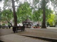
- There are several pathways throughout the gardens which have a surface of block paving, flagstone paving or tarmac.
- There are several benches/seating areas available throughout the gardens.
- There are bus stops located nearby on Oxford Street, next to Primark.
The nearest tube station is Tottenham Court Road, located on Oxford Street, and has step free access available. - There is limited on-street pay-by-phone parking available on surrounding roads.
- There are no toilet facilities nearby.
- For information about Oxford Street - Oxford Circus to Tottenham Court Road please click here.
Getting Here (Oxford Street - Between Oxford Circus and Tottenham Court Road)
-
By Bus
View
- Bus routes 55, 73, 98 and 390 travel along this section of Oxford Street.
It is also served by night bus routes N8, N25, N55, N73, N98 and N207.
Only routes 98, 390, N98 and N207 travel the full length of Oxford Street.
The number of bus routes and the location of the bus stops may change as part of the Oxford Street District improvement works.
All London buses have ramp access and dedicated spaces for wheelchair users. - For more information on London buses (Transport for London) please click here (opens new tab).
- Bus routes 55, 73, 98 and 390 travel along this section of Oxford Street.
-
By Underground
View
- Tottenham Court Road Station is served by the Central Line and the Northern Line services.
Tottenham Court Road has step-free access.
The accessible step-free entrances (with lifts) are on both sides of the Oxford Street/ Charing Cross Road junction.
The entrance off the north-east side of Oxford Street/ Tottenham Court Road is accessed by steps only.
Oxford Circus Station is served by the Central, the Bakerloo and the Victoria Line services.
This station is accessed by steps only. - For more information on London Underground (Transport for London) please click here (opens new tab).
- Tottenham Court Road Station is served by the Central Line and the Northern Line services.
-
By Train
View
- London Euston Station and London Charing Cross Station have step-free access to all platforms and staff available to assist with ramps between the platform and the train.
When the new Elizabeth Line opens, there will be accessible stations at Tottenham Court Road and Bond Street. - For more information on access and facilities at Euston Station please click here (opens new tab).
- For more information on access and facilities at Charing Cross Station please click here (opens new tab).
- London Euston Station and London Charing Cross Station have step-free access to all platforms and staff available to assist with ramps between the platform and the train.
-
By Road
View
- Oxford Street (A40) connects with Edgware Road (A5) and Park Lane (A4202) at Marble Arch, at its west end.
At its east end, it connects with Tottenham Court Road / Charing Cross Road (A400).
Regent Street (A4210) crosses the centre of Oxford Street at Oxford Circus.
Oxford Street is in the Central London Congestion Charge Zone (charges apply Monday - Friday 07:00 -18:00).
It is also in the Ultra Low Emission Zone (charges apply at all times for non-compliant vehicles).
Motor vehicles must not enter Oxford Street via Portman Street / Park Street or Oxford Circus between 07:00 and 19:00 on Monday to Saturday inclusive, except for taxis and buses. The definition “motor vehicles” therefore means that cycles and other pedal-powered devices are also exempt.
Vehicles are banned from turning left from Orchard Street into Oxford Street between 07:00 and 19:00 on Monday to Saturday inclusive, except for taxis, buses and pedal cycles. - For more information on driving in London please click here (opens new tab).
- Parking in the area is very limited and visitors are encouraged to use public transport.
There are Blue Badge bays in Ramillies Street, Wells Street and Berners Street.
There are standard on-street pay-to-park bays in many of the side roads. - For more information on the Blue Badge Scheme and parking in London please click here (opens new tab).
- For more information on where you can park with a disabled parking badge please click here (opens new tab).
- For more information on applying for a disabled parking badge please click here (opens new tab).
- London black cabs can be hailed in any location or summoned by phone.
There are taxi ranks on Argyll Street and Berners Street.
- Oxford Street (A40) connects with Edgware Road (A5) and Park Lane (A4202) at Marble Arch, at its west end.
-
By River
View
- 6 TFL River Bus routes run from 22 piers between Putney and Woolwich.
The nearest pier is Westminster.
This is close to Westminster Underground Station on the Jubilee Line which connects to Bond Street Station.
There is step-free access onto the river buses, except at 3 piers.
Please see the TFL website for details. - For more information on London River Bus services please click here (opens new tab).
- 6 TFL River Bus routes run from 22 piers between Putney and Woolwich.
-
By Air
View
- The nearest airports to central London are London City Airport, London Gatwick and London Heathrow.
London City Airport is connected to the centre by the Docklands Light Railway (DLR) to Bank or Tower Gateway, with interchanges to the rail and underground network at Canning Town and Stratford.
From Gatwick Airport there are fast trains connecting to London Bridge Station.
Heathrow Airport is connected by fast trains to Paddington Station and is also on the Piccadilly underground line. - For more information on travelling to London by air please click here (opens new tab).
- The nearest airports to central London are London City Airport, London Gatwick and London Heathrow.
-
Useful Links
View
- Please use the TfL journey planner for details of the most suitable routes.
The planner can be filtered by options such as step-free routes or maximum walking distances. - To view the web page described above click here (opens in new tab).
- The TfL website has links to the TfL accessibility guides, including large print maps and audio guides to order or download.
- To view the web page described above click here (opens in new tab).
- Please use the TfL journey planner for details of the most suitable routes.
On Street Parking (Soho Square)
-
On Street Standard Parking
View
- Standard on street parking is available.
- The on street standard parking bay(s) is/are located on Soho Square.
-
Comments
View
- The on street parking bays are pay-by-phone.
- There are additional on street parking bays on surrounding streets.
- On Soho Square there are marked parking bays for motorcycles and fixed cycle racks opposite Soho Street.
Access Point (Soho Square/Soho Street)
-
Access Point
View
- This information is for the access point located on Soho Square, opposite Soho Street.
- There is step-free access at this access point.
- There is a gate which opens away from you (push).
- The gate is permanently held open.
- The width of the gap is 115cm.
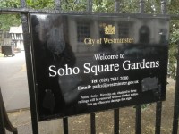
- There is an information board/map at this access point.
Access Point (Soho Square/Carlisle Street)
-
Access Point
View
- This information is for the access point located on Soho Square, opposite Carlisle Street.
- There is step-free access at this access point.
- There is a gate which opens away from you (push).
- The gate is permanently held open.
- There is an information board/map at this access point.
Access Point (Soho Square/Sutton Row)
-
Access Point
View
- This information is for the access point located on Soho Square, opposite Sutton Row.
- There is ramped/sloped access at this access point.
- There is a gate which opens away from you (push).
- The gate is permanently held open.
- There is an information board/map at this access point.
-
Ramp/Slope
View
- The ramp/slope is located on the approach to the access point.
- The gradient of the ramp/slope is slight.
Access Point (Soho Square/Bateman's Buildings)
-
Access Point
View
- This information is for the access point located on Soho Square, opposite Bateman's Buildings.
- There is ramped/sloped access at this access point.
- There is a gate which opens away from you (push).
- The gate is permanently held open.
- The width of the gap is 115cm.
- There is an information board/map at this access point.
-
Ramp/Slope
View
- The ramp/slope is located on the approach and immediately beyond the access point.
- The gradient of the ramp/slope is slight.
General Accessibility (Soho Square Gardens)
-
Paths and Pavements
View
- There is step-free access throughout the majority of the gardens.
The surface of the paths throughout the gardens consist of block paving, flagstone paving and tarmac.
Some paths are uneven in places with a mixture of very slight and slight slopes. - There are some steps on the pathway opposite the Soho Square/Bateman's Buildings Access Point.
There are 3 steps, 16cm high with a handrail available on both sides. - There are some slight slopes throughout the gardens that bypass the steps.
The slight slopes are located opposite the Soho Square/Carlisle Street and Soho Square/Sutton Road Access Points.
- There is step-free access throughout the majority of the gardens.
-
Street Furniture and Features
View
- There is bench seating available throughout Soho Square.
The seating is located next to or close to the pathways.
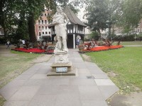
The majority of seating is 47cm high, however this may vary slightly dependant on the location. - There are several floral areas throughout.
The famous statue of Charles II is located near to the centre of the gardens. - There are a number of waste disposal bins located throughout.
- There is bench seating available throughout Soho Square.
-
Maps and Signage
View
- There are information maps located throughout Soho Square and close to each access point.
Accessible Toilet(s)
- There is not an/are not accessible toilet(s) available.
Standard Toilet(s)
- Standard toilet facilities are not available.


