

Access Guide
Introduction
- This route is from Portland Square to the Cookworthy Building.
- The route is approximately 420m long.
- It takes approximately 7 minutes to complete the route.
- The route crosses North Hill, up Gibbon Lane, left down Gibbon Street, crosses Regent Street, left down Hampton Street and across to the Cookworthy Building.
- The pavements in this area are tarmac in poor repair with numerous uneven patches and potholes.
- There are a few dropped kerbs and in some places a dropped kerb on one side of the road only.
- The route has a number of sections on gradients.
- There is extensive building work taking place which has closed Tavistock Place to vehicles and pedestrians for a considerable period of time.
- All the University buildings are clearly named and there are some wall and finger signs.
- The campus is situated on a hillside and there are sections of the route with moderately steep gradients.
Portland Square
Portland Square to North Hill
- Exit Portland Square and bear right slightly to walk down the path at a diagonal in front of you, shown in photographs 1 and 2.
- This area is surfaced with brick block paving and has an easy gradient.
- Approximately 10m down the diagonal path where it joins Sherwell Lane there is an unmarked dipped gutter running across the path, as shown in photograph 3.
- Bear right and continue along Sherwell Lane to North Hill.
- Sherwell lane has an easy gradient and an even brick block surface.
- There is infrequent use of this part of Sherwell Lane by vehicles for the Sherwell Church car park. This area is shown in photographs 4 and 5.
- As Sherwell Lane reaches North Hill there is a row of bollards along the left side of the junction, the bollards have high visibility stripes at the top. These bollards are shown in photographs 5 and 6.
North Hill to Gibbon Street
- Cross North Hill at the traffic light controlled crossing directly in front of Portland Square.
- This crossing is shown in photographs 1, 2 and 3.
- This is a traffic light controlled crossing with a level central island.
- There are dropped kerbs and tactile paving on both sides of the crossing.
- Once having crossed North Hill turn right to cross Gibbon Lane.
- The surface here is concrete slabs.
- There are dropped kerbs either side of Gibbon Lane with tactile paving as shown in photographs 4 and 5.
- Having crossed Gibbon Lane turn left.
- This area has a tarmac surface with an easy gradient.
- Head up the slope to the junction with Tavistock Place. Cross outside the pub, The Skiving Scholar.
- The kerb is low on both sides of the road but is not dropped and does not have tactile warnings, this crossing is shown in photographs 6, 7 and 8.
- The far side of Tavistock Place has a narrow, very uneven pavement.
- Tavistock Place is currently closed due to a large construction project thus there is very little traffic at this crossing.
- Once having crossed Tavistock Street turn left and follow the pavement round to the right for approximately 50m until you reach Gibbon Street.
- This stretch of pavement, shown in photographs 8, 9 and 10, is uneven with a tarmac surface, halfway along the street there is a parking ticket machine, as shown in photograph 9, that narrows the pavement to 140cm.
Gibbon Street to Regent Street
- Turn right onto Gibbon Street.
- At the start of Gibbon Street there are green electrical boxes which narrow the pavement to 135cm, this is shown in photograph 1.
- The pavement, shown in photographs 1, 3, 4 and 5, has a tarmac surface with a steep gradient.
- After approximately 45m there is a dropped kerb entrance to a car parking area.
- The kerbs are level but there is no tactile warning, as shown in photographs 2 and 3.
- Continue down Gibbon Street for approximately another 60m and pass the Robbins Conference Centre on your left, shown in photographs 5 and 6.
- Continue beyond the Robins Conference Centre along the pavement for approximately another 60m to Regent Street.
- Photographs 7 and 8 show the pavement beyond the Robins Conference Centre.
Regent Street to Cookworthy Building
- Upon reaching the Regent Street junction turn left to cross Gibbon Street.
- This crossing has dropped kerbs on both sides with no tactile paving.
- This crossing is shown in photographs 1, 2 and 3.
- Walk straight along Regent Street.
- This pavement is shown in photograph 4 and has a tarmac surface with infrequent manhole covers.
- Turn right after approximately 20m to cross Regent Street.
- This crossing is shown in photographs 5 and 6 and is level with tactile paving on both sides.
- After crossing Regent Street turn left and continue towards Hampton Street.
- This area of pavement is shown in photograph 6 and is even with a concrete slab surface.
- Upon reaching Hampton Street continue straight and cross Hampton Street.
- This cross has dropped kerbs and tactile paving on both sides with a level central island which also has tactile paving.
- This crossing is shown in photographs 7 and 8.
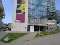
- After crossing Hampton Street turn right and the Cookworthy building is on your left approximately 60m down the street.
- Hampton Street has an even tarmac surface with a steep gradient and is shown in photographs 9 and 10.