Access Guide
Shared Section (Useful Information)
Useful Information
- Suug The Disability and Neurodiversity team are located in Founder's East. They offer support and information to students who have disclosed a disability, long standing medical condition, specific learning difficulty or mental health condition. Drop in online or go to FE153 on Tuesday, Wednesday or Thursday 11am to 2pm.
- To see more information on the Disability and Neurodiversity team please click here (opens new tab).
- Telephone Number: 01784 414 621.
- Email: [email protected].
- The Student Services Centre offers help and advice to all students.
- To see more information on Student Services Centre please click here (opens new tab).
- Telephone Number: 01784 276 641.
- Email: [email protected].
- To see more information on Accommodation please click here (opens new tab).
Introduction
- This route is from Founders Square to Car Park 12 This route is approximately 250m long and takes around 4 minutes to complete by foot. The main hazards along this route include road crossings, and slight slopes.
- Related link Founder's Chapel.
- Https://www.accessable.co.uk/venues/founder-s-building-chapel
- Related link Founder's East.
- Https://www.accessable.co.uk/venues/founders-east
- Related link Founder's Picture Galley.
- Https://www.accessable.co.uk/venues/founder-s-building-picture-gallery
Founders Square
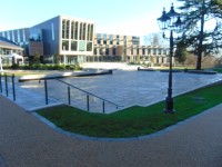
- The Founders Square is an open events space located between the Emily Wilding Davison Building and the Founders Building.
- This area is accessed via steps or ramps from the Emily Wilding Davison Building, by ramped access from the north of the campus and stepped access only from the south.
- This area has a level and even stone slab surface.
- This area contains a wide open space lined with bench seating on three sides (as shown in photographs 5 and 6) and by a tiered stone bench seating array on the north side of the square. This tiered seating is access via 15+, medium height steps with handrails on the left only.
Head up to the front of Founder's Building North
- Exit Founder's Square by taking the closest ramp to the Founder's Building. This is located to the right of the Founder's Building East Wing entrance when you are facing the entrance. This can be seen in photograph 1.
- The ramp leading off Founder's Square has an even tarmac surface with a long, slight slope. You will reach the top of the slope after approximately 70m. The slope can be seen in photographs 2, 3 and 4.
- At the top of the slope there are bollards with a width of 145cm. These can be seen in photograph 5.
- After the bollards turn left for approximately 10m to reach the road crossing. This area can be seen in photograph 6.
Founder's Building North to Campus Main Entrance Road
- Upon reaching the crossing head over the road. The road consists of block paving and is level to the pavement on either side. There is tactile paving on either side. This can be seen in photographs 1, 2 and 3.
- Upon crossing the road turn left and continue until you reach the main entrance road into the campus. The path is block paved and has a slight uphill gradient and can be seen in photographs 4 and 5.
Campus Vehicle Exit Road to Car Park 12
- Upon reaching the road, turn left along the road for 35m. There is a section of tactile paving on this side of the road after a few metres. This can be seen in photograph 2.
- Continue for another 30m along the block paved pavement.
- Along the pavement there is a bus station with a shelter as can be seen in photographs 3 and 4.
- Next to the shelter there's a bin which restricts the width of the path to 114cm. There is also a drop kerb next to the shelter. These can be seen in photographs 5 and 6.
- Continue on until you reach the Zebra crossing which has tactile drop kerbs on either side of the road which can be seen in photographs 7 and 8.
- There is another zebra crossing leading further into the car park. This can be seen in photograph 9.
Campus Main Entrance Road to Campus Vehicle Exit Road
- Cross the road in front of you.
- There is tactile paving on either side of the road.
- The road is concrete and has a width of 10m.
- The road can be seen in photographs 1, 2 and 3.
- Continue along the path in front of you for approximately 20m. This can be seen in photograph 4.
- Turn down the path to your right. The path has a slight slope of 55m. This can be seen in photograph 5.


