Access Guide
Introduction
- This route is from the Richmond Building in Queens Road to the Arts and Social Science Library on Tyndall Avenue, a distance of approximately 1km. The route also serves a number of other university buildings and passes close to others. On the route are the Victoria Rooms, Beacon House, The Hawthorns, the Senate House, the Centre for Sport, Exercise and Health, University Lettings, Careers Service and the Computer Centre. Also accessed from this route are Howard House, the Wills Physics Laboratory and the Bristol Centre for Nanoscience and Quantum Information. The route involves several areas where there is a significant gradient; these are detailed in the sections.
- Richmond Building link (new tab) - click here.
- Arts & Social Sciences Library link (new tab) - click here.
Richmond Building to Richmond Hill Junction
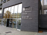
- From the main entrance of the Richmond Building (photograph 1) turn right down the gentle gradient of Queens Road. The paving surface is concrete slabs. To the right hand side of the footway there are bicycle racks (photograph 2).
- At the end of the building (approx. 50m), there is a bollard controlled parking area at the rear of the footway (photograph 3) and immediately beyond it the vehicle entrance to the University Catholic Chaplaincy (photograph 4).
- At the Chaplaincy the surface changes to a tarmac surface crossed by tactile paving for a zebra crossing (photograph 5).
- The footway narrows to 120cm wide and there is a small area of slabbed surface adjacent to the pedestrian entrance to the Chaplaincy changing back to a tarmac surface beyond (photograph 6).
- The footway bears to the right past the Queens Road sign (photograph 7) and at the sign for Richmond Hill there is a dropped kerb with no tactile warning (photograph 8).
- The dropped kerb is flush with the road surface and there are double yellow lines. Richmond Hill is one way so traffic will come only from the left. Cross the road at this point.
Richmond Hill to Queens Road Zebra Crossing
- There are tactile warnings at the dropped kerb on the Richmond Hill crossing (photograph 1).
- Immediately beyond the tactile surface there is a signpost set in the middle of the footway and another sign adjacent to the kerb edge, restricting the width (photographs 2, 3 & 4).
- The footway width between the two poles is 120cm and the surface is tarmac.
- Immediately beyond the restricted section the paving changes to a concrete slab surface with a cobbled gutter to the left of the footway (photograph 5 & 6).
- The cobbled gutter is approximately 10m long with the adjacent paving having a clear width of at least 120cm. The footpath surface then reverts to tarmac but with a concrete gutter extending for approximately 5m but still with a clear width on the right hand side of at least 120cm (photograph 7).
- There is a restaurant entrance set back on the right without any vehicle crossing (photograph 8). After about 15m the surface changes back to concrete slabs and there is a zebra crossing with tactile warnings (photographs 9 & 10).
Queens Road Zebra Crossing to Victoria Rooms Uncontrolled Crossing
- From the front of the restaurant follow the footway straight ahead for 50m, passing the parking meter which restricts the width of the pavement to 150cm (photographs 1 & 2).
- The pavement surface is level concrete slabs and there are no vehicle crossings. After 50m there is a bus stop with raised platform which has a contrast on the slopes and a surface change on the platform (photographs 3 & 4).
- Immediately beyond the bus stop is the uncontrolled crossing. There is a dropped kerb with a tactile warning (tactile bricks not standard slabs) (photographs 5-7).
- Cross to the central reservation which is level and has tactile warnings each side (photographs 8 & 9) before continuing to the opposite dropped kerb at the front of the Victoria Rooms (photograph 10).
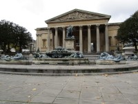
- Turn right and follow the footway to the zebra crossing in front of the fountain.
- There is an alternative using the zebra crossing but there is one kerb which is not dropped.
Alternative Route to Victoria Rooms using Queens Road Zebra Crossing (Section 1)
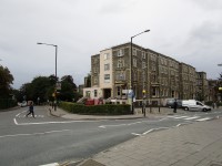
- The alternative to using the uncontrolled crossing is to cross Queens Road using the zebra crossing which has dropped kerbs and tactile paving (photograph 1 & 2) and then turn right and follow the footway across the front of the Queens Court Flats building (photograph 3 & 4).
- The footway surface is concrete slabs.
- At the end of the building (25m), immediately beyond the parking meter, there is a vehicle access to the rear of the flats with dropped kerbs and a distinctive concrete surface but no tactile warning (photograph 5, 6 & 7).
- Just beyond the vehicle crossing there is a bus stop with raised platform which has a contrast on the slopes and a surface change on the platform (photograph 8, 9 & 10).
- Immediately beyond the stop is the junction with Westbourne Place which is a one way street with traffic turning in from the right (Queens Road). There are dropped kerbs each side (photograph 11 & 12).
Alternative Route to Victoria Rooms using Queens Road Zebra Crossing (Section 2)
- At the Westbourne Place junction there are dropped kerbs on each side of the road (photograph 1).
- Continue for 25m; the pavement surface is concrete slabs but changes at the vehicle splay to the Victoria Rooms to stone slabs with an uneven surface (photographs 2-5).
- There is a dropped kerb to the vehicle crossing without tactile warning but with a surface change to tarmac and there are double yellow lines (photograph 6).
- There is no dropped kerb on the opposite side of the gateway (photographs 7-9) however, there is a sign on the gatepost for a public footpath and there is a steep downward slope to negotiate on the far side of the building and no dropped kerb to the pavement level.
- Continuing straight ahead. There is a spike chain fence to the left side of the footway protecting the drop to the level of the fountain below (photographs 10-12).
- The paving to the front of the Victoria Rooms is large stone slabs which have an uneven surface. Follow the footway to the zebra crossing in front of the fountain.
- The Queens Road is too busy to use the roadway to avoid the kerb upstand.
- It is possible to go in through the vehicle gateway and cross the front of the Victoria Rooms but on the far side the slope to the roadway is steep and there is no dropped kerb to the pavement.
Victoria Rooms to Elmdale Road Junction
- At the front of the Victoria Rooms cross Whiteladies Road towards the Royal West of England Academy of Art.
- The zebra crossing has tactile warnings and dropped kerbs on both sides of the road and also a level refuge with tactile paving in the middle of the road (photograph 1-4).
- Turn right towards Beacon House. The footway surface is concrete slabs. Pass in front of the Beacon House main entrance and turn left into Queens Avenue (photograph 5-7).
- The footway slopes down gently towards the rear entrance to Beacon House and passing Howard House on the opposite side of Queens Avenue (80m).
- The footway then rises more steeply towards Elmdale Road (40m) (photograph 8-11).
- Continue to the junction. There is no pedestrian dropped kerb but there is a vehicle crossing at 3 Queens Avenue which is level, has no tactile paving but has clear double yellow lines. Note that there is a drain with wide spaced bars within the gutter in the middle of the vehicle crossing (photograph 12 and 13).
Elmdale Road Junction to The Hawthorns
- From the Elmdale Road crossroads cross direct to Elton Road. The roadway is on a moderate slope.
- The Elton road junction is a level kerb with no tactile marking but clear double yellow lines (photograph 1). Elton Road has a local bus and cycle lane up the hill and all traffic down the road. The road is a steep slope throughout its length (photograph 2-6).
- Bristol Grammar School is on the right hand side of the road and the Grammar School Houses and Infants School on the left.
- The first part of the footway is small concrete slabs which change to a tarmac surface at the first of several vehicle crossings. There is a barrier on the right side of the pavement outside the infant school leaving a pavement width of 160cm (photograph 4).
- The vehicle crossing above the Infant School has a small upstand on the kerb but the adjacent vehicle crossing is level with the roadway (photograph 7 & 8).
- The footway surface changes to concrete at the vehicle crossing to the University Staff Club where the road begins to level out and beyond that to concrete slabs approaching the entrance to The Hawthorns and the junction with Woodland Road (photograph 9-11).
- At the junction bear left to the zebra crossing. On the forecourt of The Hawthorns is a detailed signboard and post showing all the University buildings (photograph 12).
The Hawthorns to the Arts and Social Sciences Library
- Cross Woodland Road at the zebra crossing which has dropped kerbs and tactile warnings (photograph 1) and turn right (photograph 2).
- On the wall at the junction is a detail map showing 1:21 access to the Senate Building from accessible car parking spaces to the rear of the building (photograph 3).
- Turn left into Tyndall Avenue. The footpath is a moderate slope up with concrete slab paving (photograph 4 & 5).
- Continue 50m to the main Senate House entrance on the left (photograph 6) and continue 100m up Tyndall Avenue past the Sport, Exercise and Health Building, UBU Lettings, the Careers Service and the Computer Centre all on the left and passing the Wills Physics Laboratory and the Bristol Centre for Nanoscience and Quantum Information on the right hand side of the road (photograph 7-10).
- 30m beyond the Computer Centre where the road levels out is the level access to the Arts and Social Sciences Library, clearly marked by a line of black bollards.
- The main entrance doors are to the left (photograph 12).


