
Access Guide
Summary
-
Building
View
- The journey from the Entrance to Jubilee to North Entrance of University Park via Derby Road is approximately 0.4 miles in length and takes approximately 9 minutes to travel. Along the journey there are slight and steep slopes.
Starting Point at Jubilee Campus to Wollaton Hall Drive
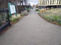
- There is a marble bench with central armrests just within the Jubilee Campus entrance.
- This route starts at the marble bench and heads towards Derby Road.
- The surface of the paving at the starting point is block paving.
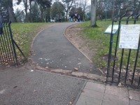
- There are 2 sets of bollards just along the path leading to the Jubilee Campus exit.
- The bollards do not contrast visually with the paving, but they have a visual identification band.
- The space between the first set of bollards is 190cm.
- There is a slight slope on exiting the first set of bollards.
- Just before the second set of bollards the paving changes to tarmac.
- The second set of bollards is approximately 6m away from the first.
- The space between the second set of bollards is 160cm.
- The slight slope continues through the second set of bollards.
- The length of the tarmac path from the second set of bollards to Derby Road is approximately 10m.
- At the end of the tarmac area there is a slight threshold.
- Approaching Derby Road, the tarmac changes colour and is patched and uneven in places.
- Continue for another 10m till you get to the Derby Road pavement.
- When you reach the Derby Road pavement, turn right.
- There is a crossing at this point.
- Do not cross at the crossing, but continue right along Derby Road on this side.
- As you turn right there is tactile paving running along the path which forms part of the pelican crossing and causes uneven surfaces.
- The pavement is level, but stay to the right as a dropped kerb causes a left hand camber.
- There is a second dropped kerb which causes a left hand camber.
- Continue ahead to the bus stop.
- Just before the bus stop is more tactile paving.
- As you approach the bus stop there is a slight slope upwards.
- Continue past the bus stop.
- Follow Derby Road for approximately 12m and you will come to Wollaton Hall Drive.
- The pavement is 150cm wide all the way along, but there are obstructions such as street lighting and CCTV poles which could cause a risk of collision.
- There is a slight slope upwards toward Wollaton Hall Drive.
- Keep to the right of the pavement as there is a steep camber to the left.
- You have now arrived at Wollaton Hall Drive.
- There are uneven surfaces caused by repairs to the pavement and manhole covers.
Crossing Wollaton Hall Drive
- As you approach Wollaton Hall Drive there is tactile paving and a dropped kerb.
- The dropped kerb creates a steep downwards slope.
- To the right of the tactile paving is a raised manhole cover which could be a trip hazard.
- Cross Wollaton Hall Drive to the central reservation.
- The distance to the central reservation is approximately 5m.
- During autumn there could be leaves on the ground which could be slippery.
- There is tactile paving on the central reservation.
- The central reservation is level.
- From the central reservation cross the second part of Wollaton Hall Drive.
- The distance from the central reservation to the far side of the road is approximately 5m.
- There is a slight camber from left to right on Wollaton Hall Drive
- As you cross from the central reservation, the road is worn in places.
- As you reach the far side of the road there is another dropped kerb.
- There is a steep slope at the dropped kerb.
- On reaching the pavement, follow the pavement to the left and continue along Derby Road.
Wollaton Hall Drive to Derby Road No's 530 - 564 Junction
- The surface of the paving is tarmac.
- The pavement is over 150cm wide.
- There are manhole covers which are uneven and may be a trip hazard along the pavement.
- There is a very easy camber from right to left.
- There are road signs and lampposts which obstruct the pavement in places.
- There are uneven surfaces caused by tree roots in places.
- There is a very easy slope leading upwards along the pavement.
- There is a raised manhole cover where the tarmac is worn and is a trip hazard.
- There is a telecommunication cover to the right with a 2cm threshold caused by worn tarmac, which could be a trip hazard.
- Continue 70m to the Queens Medical Centre bus stop.
- The width of the pavement decreases at the bus stop to 135cm.
- There is also a slight slope leading upwards to the bus stop and then down from the bus stop.
- As you pass the bus stop there is tactile paving to the left.
- There is seating at the bus stop with an armrest on the left.
- Follow the pavement past the bus stop for 8m till you come to the junction of Derby road No's 530-564.
Crossing The Junction of Derby Road No's 530 - 564 Junction
- There is a steep dropped kerb without tactile paving on the near side of Derby Road No's 530-564.
- Cross the first part of Derby Road No's 530-564 to the central reservation.
- The central reservation has dropped kerbs.
- From the central reservation it is approximately 5m to the far side.
- There is a dropped kerb on the far side of the road.
- There is tactile paving on the far side of the road.
- During autumn, leaves may accumulate and cause a slippery surface.
- During wet weather water may pool and become a trip hazard.
- On the road there are potholes which could be a trip hazard.
Derby Road No's 530-564 Junction to Subway to Queens Medical Centre
- Once you have crossed Derby Road keep following the pavement to the left.
- The pavement is tarmac.
- The pavement briefly narrows to 140cm, due to a tree which has grown across the pavement.
- Once past the tree, the pavement becomes over 150cm wide again.
- The tree has thorns which could be a hazard.
- There is a very easy camber on the pavement from right to left.
- There are also manhole covers with uneven surfaces.
- There are lampposts and road signs which obstruct the pavement.
- Continue along the pavement for 25m until you come to the subway to Queens Medical Centre.
- Just before the subway the pavement has an easy slope downwards.
Subway to Queens Medical Centre to Crossing Point
- Do not use the subway, but continue along the pavement to the right.
- The pavement is more than 150cm wide.
- There are lampposts which could create an obstruction.
- As you continue along the pavement to the right of the subway there is a very easy slope upwards.
- There is litter on the pavement which could be a trip hazard.
- Continue along the pavement for approximately 50m to the crossing point to the Queens Medical Centre.
- From the subway to the Queens Medical Centre there are street signs and telecommunication boxes which obstruct the pavement.
- There is a lamppost on route which reduces the pavement width to 135cm as you pass it.
- Do not cross the road here but continue straight ahead.
Queens Medical Centre Crossing Point to Derby Road Roundabout Crossing Point
- Do not use the crossing but continue ahead.
- At the crossing point there is a very easy downward slope.
- There is a slight camber from right to left.
- There is also tactile paving crossing the pavement at this point.
- Just past the crossing point there is a slight slope upwards towards the Queens Medical Centre Main Entrance bus stop.
- Continue 20m to the Queens Medical Centre Main Entrance bus stop.
- The bus stop causes an obstruction on the pavement.
- The pavement remains more than 150cm wide as you pass the bus stop.
- There is tactile paving to the right of the pavement as you pass the bus stop.
- There are seats with arm rests on one side.
- There are manhole covers with uneven surfaces.
- Continue for 30m to the staggered crossing at the end of Derby Road just before the roundabout.
- There is tactile paving crossing the pavement, just before the Derby Road and Clifton Boulevard crossing point.
Derby Road to Clifton Boulevard Crossing Point
- There is a steep slope to the crossing point.
- There is a tactile paving at the crossing point kerb.
- This crossing can be used by pedestrians and cyclists.
- The crossing is push button activated.
- The height of the controls is 100cm.
- There is no audible announcement at this crossing.
- There is a vibrating cone for anyone with a visual impairment, to indicate when it is safe to cross.
- There are also two visual controls to the right of the crossing, which are 150cm and 200cm high.
- Cross to the central reservation.
- There is a very easy upwards incline on the road.
- There is tactile paving at the far side of the crossing leading to the central reservation.
- The paving on the central reservation is tarmac and has a very easy slope upwards.
- Follow the pathway on the central reservation to the second crossing.
- There is a very easy upwards incline on the road.
- There is tactile paving at the far side of the crossing.
- At the far side of the crossing turn right and continue to follow the pavement to the next crossing point.
- The pathway has a slight camber from right to left.
- The pavement is more than 150cm wide but is shared by cyclists.
- There are manhole covers which have uneven surfaces.
- Continue for 30m to the next crossing.
- When you come to Derby Road roundabout crossing, turn right to face the Clifton Boulevard crossing point.
Clifton Boulevard Crossing Point to City Campus Entrance
- There is tactile paving across the pavement as you approach the crossing.
- There is a dropped kerb at the crossing.
- There is push button control to the left of the crossing.
- The height of the control button is 104cm.
- The visual controls are 150cm and 200cm.
- There is tactile paving at the crossing point.
- There is a steep slope at the crossing point.
- Cross to the far side. The distance is approximately 5m.
- There is tactile paving at the far side of the crossing.
- There is a steep slope at the far side of the crossing.
- There is a manhole cover with uneven surface which could be a trip hazard.
- Turn right after the crossing.
- There is a steep slope on the pavement.
- There are sign posts which cause obstruction on the pavement.
- Turn left and follow the path.
- There is an easy upward slope.
- There is a steep camber from right to left.
- Follow the pathway for approximately 15m to the next crossing.
- There is tactile paving at the crossing point.
- There is a steep slope at the crossing point.
- The crossing point is push button activated.
- The button is 103cm high.
- The visual displays are 160 and 200cm high.
- Cross the road at the crossing point.
- The distance to the far side is approximately 6m.
- There is tactile paving on far side of the crossing.
- There is an easy slope on the far side of the crossing.
- Ahead is the entrance to the City Campus.
Entrance to City Campus
- There on no doors or gates at the entrance.
- The entrance is more than 150cm wide.
- There is an uneven threshold which may be a trip hazard.
- There is a steep upward slope just beyond the entrance.
- Follow the pathway for approximately 15m and turn left onto the adjoining path.
- There are uneven areas of paving on this path.
- There is an easy upward slope.
- This path is used by pedestrians and cyclists.
- After 15m the pathway becomes a steep slope downwards.
- Ahead is a zebra crossing which will take you onto the main City Campus.