
Access Guide
Summary
-
Service
View
- The journey from the Visitors Car Park to Humanities Building is 0.6 miles in length and takes approximately 12 minutes to travel. Along the journey are slight and steep slopes. The route crosses Library Road and Beeston Road.
-
Building
View
- University of Nottingham Car Park link (new tab) - click here.
- Sir Clive Granger Building link (new tab) - click here.
- Hallward Library link (new tab) - click here.
- Law and Social Sciences Building link (new tab) - click here.
- Lenton Grove link (new tab) - click here.
- Humanities link (new tab) - click here.
Starting Point - Visitors Car Park
- For more information on the Visitors Car Park please follow the link below:
- www.accessable.co.uk/sir-clive-granger-building/university-of-nottingham-car-park.
Site/Campus Car Park (University of Nottingham Car Park)
-
Car Park
View
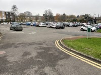
- The car park is located in the centre of the campus next to the Sir Clive Granger Building.
- The nearest building(s) to this car park is/are the Sir Clive Granger Building and the Sir Peter Mansfield Imaging Centre.
- The car park type is open air/surface.
- The car park does not have a height restriction barrier.
- The car park surface is tarmac.
- Designated Blue Badge parking bays are available.
- The Blue Badge bay(s) is/are clearly marked.
- There is/are 11 designated Blue Badge parking bay(s) within this car park.
- The dimensions of the designated parking bay(s) are 240cm x 470cm.
- The Blue Badge parking bays have a marked zone to one side and the rear.
- The marked zone is 125cm wide.
- The dimensions of the designated bays do not vary in size.
-
Charges and Restrictions
View
- This car park can be used by staff, students, visitors and Blue Badge holders.
- Parking charges apply for all except Blue Badge holders.
- Signs are provided to give information on parking charges/restrictions.
- Signs are clearly presented.
- Payment can be made by phone.
- To see more information on parking policies please click here (opens new tab).
-
Drop Off Point
View
- There is not a designated drop off point in this car park.
-
Car Park Access
View
- There is not step free access from this car park.
- Buildings are clearly signposted from this car park.
- There is not a campus map available within the car park.
- The nearest designated bay is 29m (31yd 2ft) from the Sir Peter Mansfield Imaging Centre.
Visitor Car Park to Bollards
- Exit the Visitor Car Park via a path on the left side of the car park by the Blue Badge bay.
- There is a dropped kerb with a surface of block paving.
- There is a signpost for Central Campus on the right.
- There is an upwards steep slope for 21 meters.
- The surface of the path is tarmac with grass at either side.
- At the top of the path turn left and take the path on the right.
- The path has a steep downwards slope which evens out after 10 meters.
- Continue along the path around the side of the building.
- The path narrows to 160cm and is uneven in places.
- There is a raised brick edge on the right and bushes on the left.
- The path is uneven in places as can be seen in photograph 10.
- At the end of the path the surface changes to concrete paving as you arrive at the entrance to the Sir Clive Granger building on the left.
- There is a wide open square in front of the Sir Clive Granger building.
- There is bench seating ahead and on the right.
- Turn left and head towards two bollards.
- There are cycle parking on the left and right.
Bollards to Library Road Crossing
- There are two bollards in the middle of the path.
- The bollards contrast well with the concrete surface.
- The bollards are 60cm high.
- The distance between the bollards is 104cm.
- The path has an easy upwards slope.
- The surface of the path is concrete.
- There are two Blue Badge bays on the left.
- Continue past the bollards along the path for 34m to the end of the path.
- At the end of the path turn right.
- There is a dropped kerb with tactile paving to access the pavement onto Cut Through Lane.
- The surface of the pavement is tarmac.
- The gradient is a steep slope with a camber to the left towards the road.
- There is grass on the right.
- The pavement is uneven in places.
- After 22m there is a bin on the right with a lamp post a further 6m along.
- Continue ahead for 29m when the path levels out briefly before becoming a slight downwards slope.
- Continue ahead for 16m.
- There is bench seating on the right.
- The path now forks into two.
- Take the right fork towards Library Road crossing.
Library Road Crossing
- There is level kerb and tactile paving at the crossing of Library Road.
- There is no marked crossing.
- The crossing is 4 meters long.
- Traffic comes from the left and right.
Library Road Crossing to Internal Campus Road Crossing
- After crossing Library Road continue ahead.
- The surface of the path is tarmac.
- The path is an easy downwards slope.
- There is a path leading to Hallward Library on the right.
- There is an information board on the right for the bus services.
- After 37 meters there is a path on the right which leads to the Security Office.
- The path has corduroy hazard warning surfaces at this point as can be seen in photographs 5 and 6.
- Continue past the path and down the slope for 39 meters to the crossing at the side of the Law and Social Sciences Building south entrance.
- Along the path there is bench seating on the right.
Internal Campus Road Crossing
- There is an internal campus road to cross.
- The road does not have a marked crossing.
- The road has dropped kerbs and tactile paving.
- The road is 4 meters wide.
Internal Campus Road Crossing to Beeston Road Crossing
- After crossing the internal campus road continue ahead.
- There are steps to the south entrance to the Law and Social Sciences Building on the right.
- The surface of the path is tarmac.
- The path has an easy downhill slope.
- After 30 meters the entrance to the west wing of the Law and Social Science Building is on the right.
- Continue past this entrance for 43 meters.
- There is map signage on the right.
- The gradient of the path is now steep downhill.
- Follow the path round to the right where the path widens out.
- There is a wall on the right and grass and lampposts on the left.
- There is a dropped kerb with tactile paving towards the left - photograph 6.
- At the end of the wall take the path on the right.
- The path is signposted Lenton Grove and Humanities Building as can be seen in photograph 8.
- The path has a steep upwards gradient for 5 meters which then levels out briefly before becoming a long steep downwards slope with no resting places.
- The slope curves to the right and left all the way down.
- There are grass and trees on the left and right.
- After 124 meters there is an Activity Station on the left.
- There is bench seating with no armrest towards the bottom of the path.
- Continue along the path for a further 146 meters to Beeston Lane.
- The path becomes level towards the end of the path.
Beeston Road Crossing
- There is a zebra crossing to cross Beeston Road.
- The crossing has dropped kerbs and tactile paving on both sides of the road.
- Traffic comes from the left and right.
- The crossing is 7 meters wide.
- Immediately ahead over the crossing is Lenton Grove History.
Beeston Road Crossing to Humanities
- After crossing Beeston Road turn right.
- The path surface is tarmac.
- There is a bus stop on the left after 27 meters.
- There is a university campus map and a bin at the side of the bus stop.
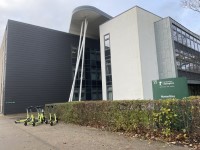
- Continue for a further 11 meters then turn left to the entrance to the Humanities Building.
- There is scooter parking on the right before the entrance.
Finishing Point - Humanities
- For more information on the Humanities Building please follow the link:
- www.accessable.co.uk/humanities.