Access Guide
Summary
-
Building
View
- The journey from the Visitors Car Park to Wollaton Park is approximately 0.5 miles in length and takes 12 minutes to travel. Along the journey are slight and steep slopes. There are crossing points on Beeston Lane and Derby Road (A52).
- Visitor Car Park link (new tab) - click here.
- Cripps Hall link (new tab) - click here.
- Hugh Stewart Hall link (new tab) - click here.
- Cripps Hall Guest Annex link (new tab) - click here.
- Lenton Hall link (new tab) - click here.
- Lenton Hurst link (new tab) - click here.
- Lincoln Hall link (new tab) - click here.
Starting Point - Visitor Car Park
- For more information on Visitor Car Park please follow the link below:
- www.accessable.co.uk/sir-clive-granger-building/university-of-nottingham-car-park.
Site/Campus Car Park (University of Nottingham Car Park)
-
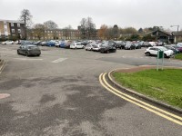
Car Park
View
- The car park is located in the centre of the campus next to the Sir Clive Granger Building.
- The nearest building(s) to this car park is/are the Sir Clive Granger Building and the Sir Peter Mansfield Imaging Centre.
- The car park type is open air/surface.
- The car park does not have a height restriction barrier.
- The car park surface is tarmac.
- Designated Blue Badge parking bays are available.
- The Blue Badge bay(s) is/are clearly marked.
- There is/are 11 designated Blue Badge parking bay(s) within this car park.
- The dimensions of the designated parking bay(s) are 240cm x 470cm.
- The Blue Badge parking bays have a marked zone to one side and the rear.
- The marked zone is 125cm wide.
- The dimensions of the designated bays do not vary in size.
-
Charges and Restrictions
View
- This car park can be used by staff, students, visitors and Blue Badge holders.
- Parking charges apply for all except Blue Badge holders.
- Signs are provided to give information on parking charges/restrictions.
- Signs are clearly presented.
- Payment can be made by phone.
- To see more information on parking policies please click here (opens new tab).
-
Drop Off Point
View
- There is not a designated drop off point in this car park.
-
Car Park Access
View
- There is not step free access from this car park.
- Buildings are clearly signposted from this car park.
- There is not a campus map available within the car park.
- The nearest designated bay is 29m (31yd 2ft) from the Sir Peter Mansfield Imaging Centre.
Visitors Car Park to Ramp or Steps
- Exit the car park at the rear right hand corner.
- There is a ramp and steps here.
- The ramp is on the right of the steps.
- The ramp has handrails on the right to the turn and then on the left.
- The ramp is steep with resting spaces at regular intervals.
- Alternatively there are 7 clearly marked steps.
- The steps are 10cm high and 41cm deep.
- There is a handrail on both sides of the steps.
- The handrail is 96cm high.
- There is a corduroy hazard warning surface at the top and bottom of the ramp and steps.
Lenton Hall Drive Crossing
- At Lenton Hall Drive there is a dropped kerb and tactile paving.
- The road does not have a marked crossing.
- The road is 5 meters wide.
- There are parked cars on the right which may cause an obstruction to the view of traffic coming from the right.
- Traffic comes from the left and right.
Lenton Hall Drive Crossing to Beeston Lane
- After crossing Lenton Hall Drive continue ahead through the gap in the fence.
- The gap is 320cm wide.
- There is a steep downwards slope.
- Take the path on the right.
- The surface is tarmac with grass on both sides.
- The path is 160cm wide.
- After 5 meters the path levels out.
- Continue ahead for 67 meters.
- There is a camber to the left along the path.
- After 67 meters there is a lamppost on the right and a signpost on the left.
- Follow the path round to the right towards Beeston Lane.
- The path narrows at this point to 110cm.
- Continue along the path for 30 meters on an easy upwards slope.
- There is grass on the right and a hedge on the left.
- At the end of the path turn right and go ahead for 2 meters to the zebra crossing.
- There is a steep upwards slope to the crossing.
- There is a raised grate cover on the path to the crossing.
Beeston Lane Crossing
- There is a zebra crossing at Beeston Lane.
- There are level kerbs at the crossing on both sides.
- There is tactile paving on both sides of the crossing.
- The crossing is 6 meters long and the traffic comes from both the left and right.
Beeston Lane Crossing to Beeston Lane
- After crossing Beeston Lane continue ahead for 14 meters.
- The surface of the path is block paving.
- There is a bin on the right and a fence on the left.
- The path is an easy uphill slope.
- After 14 meters turn left.
- There is a sign on the wall showing the Accessible Route.
- Follow the path for 31 meters.
- The path has a steep downwards slope.
- At the end of the path turn right on to Beeston Lane.
- The surface changes to tarmac.
Beeston Lane to Internal Campus Road
- Follow the path along Beeston Lane for 184 meters.
- The path is a steep downwards slope.
- The path is 130cm wide.
- The surface is tarmac.
- After 7 meters there is a signpost on the right for Lenton Hurst.
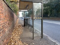
- After 10 meters there is a bus stop on the right.
- Lincoln Hall is on the left.
- Continue past the bus stop and down the slope.
- There is a steep camber to the left after the bus stop.
- Follow the path for a further 30 meters.
- The path then begins an easy slope upwards.
- The kerb is on the left and there is grass on the right.
- There are lampposts on the right at regular intervals.
- After 74 meters there is a dropped kerb to the left.
- As you pass the dropped kerb the slope becomes steep a upwards gradient.
- After a further 36 meters turn right onto an internal campus road.
- There is a dropped kerb with tactile paving at the end of the path.
Internal Campus Road to Derby Road
- The internal campus road is a long steep uphill slope.
- There is no pavement along this road.
- The surface is tarmac.
- The surface is uneven in places (see photograph 6).
- The path winds round to the right and then to the left.
- There is grass and trees on either side of the road.
- Follow the road for 112 meters.
- Lenton Hurst Building is on the right.
- After 112 meters there is a path on the left by the side of the garages.
- The path is an easy uphill slope.
- The surface is tarmac and is uneven.
- There is a drainpipe on the right which reduces the path to 85cm at this point.
- There are railings on the right.
- At the end of the path, approximately 9 meters, turn right onto Derby Road.
- There is an electricity box on the right which narrows the path to 105cm.
- Continue along Derby Road for 2 meters.
- The road is a steep uphill slope.
- After 2 meters there is a pedestrian crossing on the left.
- Cross Derby Road using the pedestrian crossing.
Derby Road Crossing
- To cross Derby Road use the pedestrian crossing.
- The pedestrian crossing has visual and audible indicators.
- There are push button controls on the left and right of the crossing.
- The height of the push button control is 100cm.
- The crossing has dropped kerb and tactile paving on both sides.
- The crossing is 7 meters long.
- Traffic comes from the left and right.
- Derby Road (A52) is a very busy road so there may be a few minutes wait for the crossing.
Derby Road Crossing to Bus Stop
- After crossing Derby Road turn right.
- Continue ahead for 25 meters towards the bus stop.
- The path is 150cm wide and surface is tarmac.
- There is a lamppost on the left which reduces the width of the path to 130cm at that point.
- The pavement has an upwards steep slope.
- There are railings on the right for 18 meters and a wall on the left.
Finishing Point - Derby Road Bus Stop
- The bus stop is on Derby Road (A52).
- The bus stop is Wollaton Park Gates (Stop UN12).
- The buses that stop here are 35, 36 and i4.
- The buses travel to Nottingham.


