Access Guide
Summary
-
Building
View
- The route from the West Entrance to Highfield is approximately 0.4 miles long and takes approximately 10 minutes to travel. Along the journey are slight and steep slopes. The route crosses Beeston Lane and University Boulevard. The route goes through Highfield Park.
- Florence Boot Hall link (new tab) - click here.
Starting Point - West Entrance
- The West Entrance to the University of Nottingham is located off Woodside Road/University Boulevard.
West Entrance to Willoughby Close
- Enter the University of Nottingham via the West Entrance.
- Take the path on the left of the West Entrance.
- The security post is on the right.
- This path is shared with cyclists therefore keep to the left.
- There is segregated shared cycle track and footpath surface at the start of the path.
- The path has an easy downhill gradient.
- The surface is tarmac and the path is 130cm wide.
- After 15 meters there is a lamppost on the left which narrows the path to 105cm.
- The gradient changes to an easy uphill for 39 meters.
- At 28 meters there is a lamppost in the middle of the path which narrows the path to 80cm.
- At the end of the path there is an entrance road to Willoughby Close.
- Follow the path round to the left along Willoughby Close to the dropped kerb.
Willoughby Close Crossing
- There is a dropped kerb with tactile paving to cross Willoughby Close.
- The road does not have a marked crossing.
- The road is 3 meters wide.
- Traffic comes from the left and right.
Willoughby Close to Beeston Lane Crossing
- After crossing Willoughby Close turn right and follow the path around to the left.
- The path has an easy uphill gradient.
- The surface of the path is tarmac.
- There is a University Campus Map on the left.
- There is a grate on the path which is slightly raised and the path is uneven in places as can be seen in photographs 3 and 5.
- Continue on the path for 50 meters to the zebra crossing on the right.
Beeston Lane Crossing
- There is a zebra crossing to cross over Beeston Lane.
- The crossing has dropped kerbs and tactile paving on both sides.
- The crossing is 6 meters long.
- Traffic comes from the left and right.
Beeston Lane Crossing to Entrance to Florence Boot Hall
- After crossing Beeston Lane turn left.
- The surface of the path is tarmac.
- There are railings and an lamppost on the right and the kerb on the left.
- The gradient of the path is an easy uphill slope.
- After 20 meters follow the path around to the right.
- There is a dropped kerb for a zebra crossing on the left.
- For 14 meters the path is a steep uphill slope.
- The path narrows to 100cm with a wall on the right.
- Continue past the wall and the path widens out again.
- There is a dropped kerb with tactile paving on the left.
- Go past the dropped kerb and follow the path round to the right to the entrance road to Florence Boot Hall.
Florence Boot Hall Entrance Road Crossing
- At the entrance road to Florence Boot Hall there is an internal campus road to cross.
- The road has a dropped kerb and tactile paving on both sides.
- The road is 3 meters wide.
- Traffic comes from the left and right.
Florence Boot Hall Entrance Road Crossing to Highfields Park
- After crossing the road at Florence Boot Hall entrance road turn left and follow the path around to the right onto Jubilee Avenue.
- After 8 meters there is a dropped kerb on the left.
- The surface of the path is tarmac.
- The path has a grate which is slightly uneven.
- The path has an easy uphill gradient and a camber to the left.
- Follow the path for 44 meters to the entrance road to Highfields Park on the right.
- There is no dropped kerb between the path and the road.
- There is a 8cm step.
- There is a sign for the tram stop on the right.
- There are two bollards at the start of the road.
- The bollards are 105cm high with a width of 114cm between them.
- Go through the bollards and continue straight on to the entrance to Highfields Park.
- The surface of the road is tarmac with an easy upward slope.
- After 37 meters there is a large concrete pipe in the middle of the path.
- The width at the left of the pipe is 155cm and on the right is 170cm.
- After the pipe are the gates for Highfields Park.
Highfields Park to University Boulevard
- Follow the path through Highfields Park.
- The surface of the path is tarmac and is uneven in places as can be seen in photograph 2.
- The gradient is a steep downhill slope 50 meters before levelling out.
- There is grass and shrubs on either side of the path.
- After 26 meters there is a park map on the left.
- The gradient of the path changes to an easy uphill slope.
- After 40 meters the entrance to the Serenity Gardens is on the right.
- There is bench seating in the Serenity Gardens.
- Continue on the path for a further 7 meters to a bridge.
- There is a steep uphill slope at the bridge with a camber to the left and right.
- Continue for a further 20 meters to the exit gates for the park.
- The exit gates are double gates with one locked.
- The width of the gates is 180cm.
- Exit the park through the gates onto University Boulevard.
- The surface changes to paving stones.
- After 3 meters take the path on the right to the pedestrian crossing.
University Boulevard Crossing
- There is a Pedestrian Light Controlled crossing to cross University Boulevard.
- The crossing is staggered across the dual carriageway.
- There are push button control on the left and right of the crossing.
- There is a rotating cone on the underside of the control box on the right.
- The crossing also has a visual indicator.
- There is a level kerb on one side of the crossing and a dropped kerb on the other.
- There is tactile paving on both sides.
- Traffic comes from the right at the first part of the crossing and the left at the second part of the crossing.
University Boulevard Crossing to Tram Stop
- After crossing University Boulevard turn right.
- Continue along the path for 37 meters to the tram stop.
- The surface of the path is tarmac.
- The gradient of the path is level.
Finishing Point - University Boulevard Tram Stop
- University Boulevard is a tram stop on the Nottingham Express Transit (NET) network in the city of Nottingham.
- It is situated on reserved track alongside University Boulevard (A6005) close to the boulevard's junction with Queen's Road East and Lower Road
- The tram stop is on line 1 of the NET, from Hucknall via the city centre to Beeston and Chilwell.
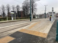
- The tram stop has platforms on either side.
- There is a steep slope to access the tram stop.
- The slope has corduroy hazard warning paving at the start of the slope.
- There is a lozenge platform edge warning surface on the left of the tram stop.


