Access Guide
Introduction
- This information is for a route between the Sherwell Centre and the Robins Conference Centre.
- This route is approximately 500m long and should take 7 minutes to walk.
- This route is via North Hill, Charles Street, Regent Street and Gibbon Street.
- The main hazards on this route are uncontrolled street crossings, congested paving areas and restaurant seating and advertising on the pavement.
Sherwell Centre
Sherwell Centre to North Hill
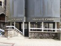
- Exit the Sherwell Centre to the left via the building ramp, shown in photograph 2, and walk ahead keeping to the left onto Sherwell Lane for 45m.
- This area has brick block paving and is even with an easy slope leading down away from you, shown in photograph 3.
- Sherwell Lane is almost completely pedestrianised with infrequent car use to access the Sherwell Centre car park as shown in photograph 4, there is a 5mph speed limit for vehicles and pedestrians have right of way in this area.
- Head down Sherwell Lane between Portland Square and the Sherwell Centre car park.
- There is a line of removable bollards level with the start of the Sherwell Centre car park, they are approximately 100cm apart and are frequently not in use. These bollards were not in use at the time of the survey
- At the end of Sherwell Lane there is a line of removable bollards, a minimum of 140cm apart, that only covers the left 5m of the pavement joining North Hill, the bollards have a double high visibility strip at the top. This area is shown in photographs 5 and 6.
- Bear slightly right to join North Hill.
North Hill to Charles Street
- North Hill has even concrete slab paving with an easy downhill slope, shown in photograph 1.
- Head along North Hill for approximately 100m.
- After approximately 25m there are a series of 4 bus stops at 20m intervals as shown in photographs 2 and 3.
- The bus stops leave plenty of room on the right-hand side of the pavement but may cause congested pavements at peak times due to people waiting for buses.
- 10m beyond the last bus stop there is a line of yellow corduroy tactile paving across the pavement, shown in photograph 4. This marks the start of the traffic light-controlled crossing opposite the Roland Levinsky Building and a widening of the pavement.
- Cross North Hill at this traffic light controlled crossing point. There is a line of red blister tactile paving leading from this crossing across the pavement, shown in photograph 6.
- This crossing has tactile paving and dropped kerbs on both sides and is split by a central island which has level concrete slab paving between the two crossing points and tactile paving and dropped kerbs on both sides of the island. This crossing and central island are shown in photographs 5, 6, 7 and 8.
- The control boxes at this crossing point are approximately 100cm high and there is no audible warning.
- Once you have crossed North Hill at the traffic lights turn right and continue along North Hill.
- Along this stretch of pavement there is uneven flagstone paving with an easy gradient. There are hoardings along the left of the pavement due to long term building work, shown in photograph 9.
- Approximately 20m along North Hill from the crossing is a sign post which narrows the pavement to 120cm on the left, shown in photograph 10.
- Continue to Charles Street.
Charles Street to Tavistock Place
- Continue from Charles Street onto Tavistock Place as the path opens up beyond the hoardings. This area is shown in photographs 1 and 2.
- This area is surfaced with concrete slabs with some uneven guttering running across the pavement
- The left side of the pavement is normally crowded with seating areas and advertising boards for the restaurants and shops along this area of the street.
- Approximately 60m further along the pavement splits.
- Keep to the left of the pavement and follow the pavement around the corner to the left.
- There is a line of corduroy tactile paving as the pavement splits, shown in photograph 3.
- Continue along Tavistock Place for 35m.
- The pavement surface is tarmac with an easy slope and metal guttering and manhole covers.
- Tavistock Place narrows down to 130cm between bins and a signpost as shown in photograph 4. The area beyond this on Tavistock Place is shown in photograph 5.
- At the time of survey major construction work is taking place along Tavistock Place and the majority of the road is closed.
- Shortly before reaching the road works turn right to cross Tavistock Place.
- Offset dropped kerbs can be found by using the dropped kerb for the On-street car park on the near side of the road (shown in photograph 5) and the dropped kerb outside the Caffeine Club coffee shop on the far side of the road (shown in photograph 6).
- This road is very quiet with occasional slow moving construction traffic due to the major construction project on Tavistock Place.
Tavistock Place to Gibbon Street
- After crossing Tavistock Place turn right and follow the pavement around to the left onto Regent Street.
- This area of pavement is uneven with a tarmac surface and infrequent manhole covers, as shown in photograph 1.
- The pavement narrows through this corner due to a green electrical box to 140cm and a lamppost narrowing the pavement to 130cm as shown in photograph 2.
- Continue along Regent street for 60m to Chapel Street.
- This stretch of pavement is level tarmac as shown in photograph 3, with some metal guttering across the pavement as shown in photograph 4.
- Cross Chapel Street.
- This crossing is shown in photograph 5 and 6 and has dropped kerbs on both sides, this is a quiet road.
- The near side dropped kerb is impinged by the entrance to Jakes fish and chip shop.
- The far side of the crossing is slightly offset to the right and at the time of survey had a road works sign blocking the majority of the left area of the pavement.
- Immediately cross the car park access road.
- This crossing has dropped kerbs on both sides and is infrequently used.
- This crossing is shown in photographs 6 and 7.
- Continue along Regent Street for approximately 40m to Gibbon Street.
- This stretch of Regent Street is level with an even tarmac surface and is shown in photographs 8, 9 and 10.
Gibbon Street to Robbins Conference Centre
- Turn left on to Gibbon Street.
- Approximately 15m along Gibbon Street there is a lamppost which reduces the pavement width on the left to 145cm.
- Gibbon Street is surfaced with even tarmac with a steep slope leading up away from you.
- The Robins Conference Centre is approximately 60m along Gibbon Street.


