Access Guide
Introduction
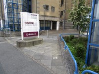
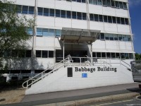
- This is a route from the Robbins Conference Centre to the Babbage Building.
- The route is approximately 500m long.
- It takes approximately 10 minutes to complete the route.
- The route follows Gibbon Street to its junction with Regent Street then left to Tavistock Place, around the curve of Charles Street to the crossing on North Hill. From there the route is pedestrianised along Glanville Street to James Street and the Babbage Building.
- The street surface is tarmac, and the pedestrianised surface is block paved.
- The tarmac paving is very uneven in places and there are sections with low but not dropped kerbs.
- There is extensive building work taking place at the City Museum and Art Gallery where a new History Centre is being developed to open in 2020.
- During these works, Tavistock Place is closed to traffic and the dropped kerbs may be difficult to access.
- All the University buildings are clearly named and there are some wall and finger signs.
- Throughout the campus, University vehicles may use the pedestrian areas.
- They are restricted to 5mph and the pedestrians have right of way.
- The campus is situated on a hillside and there are sections of the route with moderately steep gradients.
Robbins Conference Centre
Gibbon Street to Regent Street
- The Robbins Conference Centre is halfway down Gibbon Street.
- As you exit the site turn right down the slope to Regent Street.
- This pavement has an even tarmac surface with a steep gradient and is shown in photographs 1, 2, 3 and 4.
Regent Street to Tavistock Place
- At the junction of Gibbon Street with Regent Street turn right.
- This pavement is even and level with a tarmac surface as shown in photographs 1 and 2.
- After approximately 50m there is an entrance into a car park area.
- The kerbs are dropped both sides of the entrance but have no tactile warnings as shown in photographs 3 and 4.
- Immediately beyond the vehicle crossing is the entrance to Chapel Street.
- There is no dropped kerb although the kerb is very shallow.
- The corresponding dropped kerb outside Jake's Fast Food Shop is level but within the cobbled section of the street, this crossing is shown in photographs 4 and 5).
- Beyond the crossing continue along Regent Street.
- The pavement here, shown in photographs 6 and 7, is narrow (120cm) and is uneven in places.
- At the junction with Tavistock Place there are some sections of dropped kerb and some uneven areas of pavement.
- The dropped kerbs do not line up but work is ongoing in this area.
- Tavistock Place is gated at this point so traffic is scarce, this crossing is shown in photographs 8, 9 and 10.
Tavistock Place to North Hill
- From Tavistock Place follow the curve of the pavement around the Charles Street corner.
- The tarmac in this section, shown in photographs 1 and 2, is uneven.
- There is a line of corduroy paving across the footpath to show that the next section of pavement is also part of the cycle path, as shown in photograph 3.
- Several of the businesses and restaurants in this section have tables and advertising boards on the pavement.
- The pavement in this area changes to concrete slabs and is even. This area is shown in photographs 4 and 5.
- Continue up the slight slope towards North Hill.
North Hill to Roland Levinsky Building
- Continue ahead onto the section of North Hill which is protected by hoardings during the project which will not be completed until 2020.
- The pathway is 150cm wide and has passing places built in where there is street furniture, as shown in photographs 2.
- The pavement has an uneven flagstone surface with an easy gradient. This section is shown in photographs 1, 2 and 3.
- Continue for approximately 40m to the Pelican crossing which has a central reservation, indicator lights, tactile paving on all sides and rotating cones.
- This crossing is shown in photographs 4, 5, 6 and 7.
- Having crossed the second section go straight ahead for 30m to the entrance of the University reception, within the Roland Levinsky Building shown in photographs 8, 9 and 10.
- This area has an even brick block surface.
Roland Levinsky Building to James Street
- From the University main reception entrance of the Roland Levinsky Building, turn left on the pedestrianised area, shown in photographs 1, 2 and 3.
- Some vehicles use this section as there is limited short term visitor parking opposite.
- The paved area slopes up gently for 30m towards the front of the Scott Building, shown in photographs 4 and 5, and is then level for 60m, passing the Smeaton Building to the right and the Scott Building to the left before dropping gently to the junction with James Street, shown in photograph 6.
James Street to Babbage Building
- The James Street crossing has zebra markings, dropped kerbs and tactile warnings on both sides of the road.
- This crossing is shown in photographs 1 and 2.
- The road has traffic coming from both sides but there are speed restrictors throughout its length ensuring that vehicles travel at a low speed.
- After crossing James Street turn right across the front of the Marine Building.
- Immediately after you turn right there is a service vehicle entrance for the building with corduroy tactile paving shown in photographs 3 and 4.
- The footpath level does not change as shown in photograph 5.
- Continue along the footpath for 30m where there is a second service entrance without tactile markings, shown in photograph 6, leading immediately to the sloping entrance to the main entrance of the Babbage Building to your left, shown in photographs 7 and 8.
- The paving on this route is all block paving apart from the tarmac road surface.


