

Access Guide
Summary
-
Building
View
- The distance from University Metro Station to the Sciences Complex is approximately 0.4 miles in length and should take approximately 4 minutes to travel.
Along the journey are easy slopes.
Some of the pavements are obstructed by planters.
The surfaces are tarmac, block paving and concrete paving.
There is a busy crossing along the route.
. - The Sciences Complex comprises the Darwin, Dale, Pasteur and Fleming Buildings.
- Faculty of Health Sciences and Wellbeing - Unit 4 link (new tab) - click here.
- The Murray Library link (new tab) - click here.
- CitySpace link (new tab) - click here.
- The Gateway link (new tab) - click here.
- Edinburgh Building link (new tab) - click here.
- The distance from University Metro Station to the Sciences Complex is approximately 0.4 miles in length and should take approximately 4 minutes to travel.
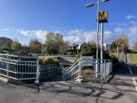
Starting Point - University Metro Station
- The University Metro Station is situated on New Durham Road with separate entrances to each platform.
- Access to the station is by footpaths from New Durham Road or Chester Road via footpaths through Sunderland University Campus.
- There are no parking facilities.
- For more information on the University Metro Station please click here.
University Metro Station to Westbound to Cycle Path
- This section is approximately 82 metre in length.
- The Westbound platform goes to South Hylton.
- There is ramp or stair access to the platform.
- Both ramp and stairs have dual height handrails.
- The ramp is located on the right as you exit the train.
- The ramp has an easy slope and the surface is tarmac.
- Follow the ramp up and round to the left.
- After 15 metres the handrails end just before the subway and are replaced by a small fence on both sides.
- At the approach to the subway entrance turn left.
- There is an easy slope 31 metres long up to the bridge.
- There are no handrails on this slope - there is a small fence on the left and a grass verge with bushes on the right.
- At the top of the slope turn left and go across the bridge.
- There is a further easy slope to access the bridge.
- The slope has dual height handrails.
- The path levels out on the bridge.
- Continue over the bridge, there is an easy slope to exit the bridge.
- There are lamp posts on the left at the start and end of the bridge.
- Alternatively, if you wish to take the stairs from the platform, the stairs are located on the left as you exit the train (photographs 15-18).
- There is tactile paving at the top and bottom of the stairs
- The stairs have dual height handrails on both sides,
- There are lamp posts on the right on the landings of the stairs.
- At the top of the stairs turn left and continue over the bridge as above.
University Metro Station to Eastbound to Cycle Path
- This section of the route is approximately 56 metres in length.
- The Eastbound platform goes to Sunderland and Newcastle.
- There is ramp or stair access to the platform.
- Both ramp and stairs have dual height handrails.
- The ramp is 39 metres long.
- On exiting the metro take the left exit.
- There is an ramp with an easy incline.
- There are lamp posts on the right after 7 metres and on the left after 26 metres.
- Continue up the ramp which turns sharply to the right after 20 metres.
- At the top of the ramp turn right and follow the path up the slope for 17 metres.
- Keep to the left on the path as this is a segregated shared cycle path, marked with ribbed tactile paving.
- The easy slope levels out at the top.
- The surface is tarmac.
- Alternatively if you wish to take the stairs from the platform, the stairs are located on the right as you exit the train (photographs 15-18).
- There is tactile paving at the top and bottom of the stairs.
- The stairs have dual height handrails on both sides.
- There are lamp posts on the right on the landings of the stairs.
Cycle Path to Chester Road Crossing
- This section of the route is 45 metres in length.
- Turn left on the cycle path (from the Eastbound platform) or cross the cycle path (from the Westbound platform).
- There is directional signage 3 metres on the right and a cycle park on the left.
- There is an easy downwards slope.
- There are no handrails on the slope.
- The surface is tarmac with grass verges on either side.
- There is a lamp post 13 metres on the right.
- There is a university campus map on the right at the bottom of the slope.
- After approximately 25 metres the path levels out.
- Follow the path round to the left.
- There are lamp posts on the right.
- There is a path on left leading to the Tech Park Unit 4.
- There is a litter bin on left.
- Continue ahead to the Chester Road crossing.
- The path slopes slightly down towards the crossing.
- The surface changes from tarmac to concrete paving.
- The Murray Library is on the right.
- There is directional signage on the right.
- There are bollards on the approach to the crossing.
- The bollards are 66 centimetres high and the distance between them varies between 154 centimetres to 336 centimetres.
- The bollards do not have any contrast markings.
- There is a strip of block paving between the bollards.
- There are also planters in front of some of the bollards.
- The planters have identification rings.
- The crossing is 2 metres beyond the bollards.
Chester Road Crossing
- The crossing is a puffin crossing.
- The crossing is 6 metres wide covering two lanes of traffic.
- Traffic comes from the left and the right.
- The crossing has audible and visible indicators.
- There are buttons for the crossing on the left and right.
- The height of the push buttons is 110 centimetres.
- There is a rotating cone on the underside to indicate when it is safe to cross.
- The rotating cone is 105 centimetres high.
- The crossing has a dropped kerb and tactile paving at either side.
Chester Road Crossing to Pedestrian Campus Walkway
- This section of the route is approximately 63 metres in length.
- After crossing Chester Road continue straight ahead.
- The CityScape building is on the left.
- There is an easy upwards slope.
- There is a university map and signage on the right.
- The surface is tarmac with block paving on the left and right sides of the pathway.
- There is a planter 3 metres from the start of the slope with an identification strip.
- There are steps leading up to the CityScape building on the left.
- The slope levels out in front of the CityScape building steps.
- The Gateway and Edinburgh Buildings are on the right.
- The easy slope then continues upwards past the Edinburgh Building on the right.
- 11 metres further along the path there are two planters.
- The distance between the planters is 135 centimetres.
- Continue ahead to the pedestrian walkway.
- There are lamp posts on the right.
- There are planters and bench seating on the left.
- There is a path on the left leading to the University Travel Hub bus stop.
- Buses from here go between the Sir Tom Cowie Campus at St Peter's and the City Campus.
- The surface is tarmac interspersed with block paving.
- There is directional signage on the left at the pedestrian campus walkway.
Pedestrian Campus Walkway to The Sciences Complex
- This section is approximately 29 metres in length.
- Cross over the pedestrian campus walkway.
- The walkway is concrete tiles.
- Continue ahead towards The Sciences Complex.
- The surface is tarmac and level.
- There are lamp posts on the right.
- There is bench seating and planters on left.
- There is an easy slope as you approach the main entrance of The Sciences Complex.
- The slope levels out at the entrance.
Finishing Point - The Sciences Complex
- The Sciences Complex comprises the Darwin, Dale, Pasteur and Fleming buildings.
- For more information on the Darwin building please click here
- For more information on the Dale building please click here
- For more information on the Pasteur building please click here
- For more information on the Fleming building please click here.