
Access Guide
Summary
-
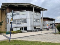
Building
View
- The journey from The Reg Vardy Centre to Wearside is approximately 0.3 miles in length.
Along the journey are slight and steep slopes.
Some of the pavements are obstructed by grit bins and scooters.
St Peter's Way has a lot of pedestrian traffic around the bus stop. - The Reg Vardy Centre link (new tab) - click here.
- The Prospect Building link (new tab) - click here.
- David Puttnam Media Centre link (new tab) - click here.
- David Goldman Technology Centre link (new tab) - click here.
- Wearside View link (new tab) - click here.
- The journey from The Reg Vardy Centre to Wearside is approximately 0.3 miles in length.
Starting Point - The Reg Vardy Centre
- For more information about the Reg Vardy Centre please click here.
The Reg Vardy Centre to University Square
- This section of the route is 29 metres long.
- Exit The Reg Vardy Centre via the rear entrance on Level 1.
- Continue ahead towards the left.
- The surface is level and is concrete slabs with block paving on the left and cobbles towards the right.
- There is a planter on the right 6 metres from The Reg Vardy Centre exit (as seen in photograph 1).
- Continue around to the left and go under the bridge towards University Square.
- Off University Square are the Sir Tom Cowie Lecture Theatre, Prospect Building, David Puttnam Media Centre and David Goldman Technology Centre.
University Square to St Peter's Way
- This section of the route is 45 metres in length.
- After going under the bridge, at University Square turn left and proceed up the slope.
- The slope is an easy slope however it is long and there are no resting areas.
- At the beginning of the slope there is a campus map on the left and directional signage on the right.
- 4 metres along the slope there are steps on the right which lead to the rear of the David Goldman Technology Centre (as seen in photograph 4).
- There are lamp posts at regular intervals on the left.
- The surface is block paving.
- There are metal railings on the right and a wall on the left (as seen in photograph 6).
- At the top of the slope there are three bollards (as seen in photograph 8).
- The bollards are 91 centimetres high and have visual identification strips at the top and bottom.
- The distance between the bollards is 120 centimetres.
- The path slopes upwards on the right at the bollards.
- There is directional signage on the right outside the David Goldman Technology Centre.
- This slope can be avoided by using the alternative exit from the Reg Vardy Centre on Level 2 onto St Peter's Way.
St Peter's Way to St Peter's Campus Bus Stop
- This section of the route is 30 metres in length.
- After passing the bollards turn left.
- There is a steep upwards slope for 5 metres which then becomes an easy downwards slope for 5 metres before levelling out.
- The alternative exit, on Level 2, from the Reg Vardy Centre is on the left (as can be seen in photograph 2).
- The surface is concrete paving stones.
- There is a recycling bin on the right 16 metres along the path.
- There is a grit bin on the left 19 metres along the path.
- The St Peter's Campus Bus Stop is on the right 23 metres along the route.
- There are scooters parked on the left near the campus bus stop which may cause an obstruction (as can be seen in photograph 4).
St Peter's Campus Bus Stop to Charles Street
- This section of the route is 64 metres in length.
- After passing the St Peter's Campus Bus Stop take the path on the right.
- The surface is concrete paving which changes to tarmac after 2 metres.
- There is an easy long slope along this path.
- There is a phone box 33 metres along the route (as can be seen in photograph 3).
- Continue to follow the path for a further 32 metres to the junction of Charles Street.
- There is a dropped kerb on the right just before the junction (as can be seen in photograph 6).
- There are hedges along the left and the kerb is on the right.
- The path is uneven in places.
Charles Street to University Main Car Park Entrance Crossing
- This section of the route is 36 metres in length.
- At the junction of Charles Street turn left.
- Continue straight ahead along Charles Street.
- The path slopes upwards slightly for 14 metres before starting to slope gently downwards towards the crossing.
- The surface is tarmac and there is block paving on the right.
- There is a lamp post on the right 10 metres along the path.
- There is a hedge on the left and the kerb on the right.
- The path is uneven in places.
- At the end of the path there is a crossing at the entrance to the university main car park.
University Main Car Park Entrance Crossing
- This section of the route is 8 metres in length.
- There is a crossing at the entrance to the university main car park.
- There are dropped kerbs on both sides of the crossing.
- There is no tactile paving at the crossing.
- There are no audible or visual indicators at the crossing.
- Traffic comes from the left and right.
University Main Car Park Entrance Crossing to Wearside View
- This section of the route is 32 metres in length.
- After crossing the road at the entrance to the university main car park continue straight ahead.
- There is a steep upwards slope (as can be seen in photographs 1 and 2).
- The path also slopes downwards towards the kerb on the right.
- Wearside View is on the left.
- The surface is tarmac.
- There are concrete tiles on the left.
- After 16 metres follow the path around to the left.
- After 6 metres the path levels out.
- Continue for a further 2 metres towards the St Peters Campus car park, then turn left and continue straight forward to the main entrance of Wearside View.
- The surface changes to concrete tiles.
- The main entrance to Wearside View is on the right.
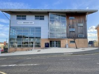
Finishing Point - Wearside View
- For more information about the Wearside View please click here.