Access Guide
Introduction
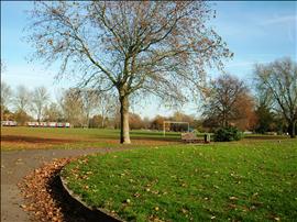
- Services / facilities within the grounds include football pitches, a cricket square, changing facilities, a children's play area, basketball hoop, a woodland walk and a model steam railway.
-
Comments
View
- The Model Railway is open on Sundays in March through to October from 13:00 - 16:00.
Location
- The venue is situated outside the centre of the town or city.
- This venue is situated in Rayners Lane.
- The venue is not situated on a road which has a steep gradient.
- The nearest mainline station is Northolt Park.
- The nearest underground station is Rayners Lane.
Parking (Cannon Lane Car Park)
- The venue does have its own car park.
-
Venue Car Park
View
- Parking is free for all users.
- The car park type is open air/surface.
- The car park is on Cannons Lane.
- There are 0 designated parking bay(s) within the car park.
- The route from the car park to the entrance is accessible to a wheelchair user with assistance.
- Assistance may be required because there is / are slopes/ramps.
- The car park surface is tarmac.
- There is not a dropped kerb / non stepped access from the car park to the venue.
- The patron does have to cross a road.
- The car park does have a height restriction barrier.
- The maximum height is 210.
-
Drop-off Point
View
- There is not a designated drop off point.
Parking (Field End Road Car Park)
- The venue does have its own car park.
-
Venue Car Park
View
- Parking is free for all users.
- The car park type is open air/surface.
- The car park is off Field End Road.
- There are 0 designated parking bay(s) within the car park.
- The route from the car park to the entrance is accessible to a wheelchair user with assistance.
- Assistance may be required because there is / are dropped kerbs.
- The car park surface is tarmac.
- There is a dropped kerb / non stepped access from the car park to the venue.
- The patron does not have to cross a road.
- The car park does have a height restriction barrier.
- The maximum height is 200.
-
Drop-off Point
View
- There is not a designated drop off point.
-
Comments
View
- This car park is for the sole use of customers of the model railway.
- The car park is only open between 13.00 and 18.00 on Sundays that the model railway is open.
Outside Access (Cannon Lane Car Park Entrance)
- This information is for the entrance located in Cannon Lane car park.
- There is not level access into the venue.
- The main doors open (no doors).
- The door opening is 290cm (9ft 6in) wide.
Level Change (Cannon Lane Car Park Entrance)
- There is a ramp or slope to access this service.
- The ramp or slope is located leading on from the barrier.
- The ramp or slope is permanent.
- The width of the ramp or slope is 290cm (9ft 6in).
- There are steps to access this area / service.
- The steps are located to the right of the slope.
- There is / are 5 step(s) to the area / service.
- The step(s) is/are not clearly marked.
- The steps are medium.
- The steps do not have handrails.
-
Comments
View
- The ramp overcomes the steps.
Outside Access (Field End Road)
- This information is for the entrance located on Field End ROad.
- The main doors open away from you (push).
- The doors are single width.
- The doors are light.
- The door opening is 90cm (2ft 11in) wide.
Outside Access (Field End Road Car Park)
- This information is for the entrance located in Field End Road car park.
- There is level access into the venue.
- The main doors open (no doors).
Outside Access (Cannon Lane Entrance)
- There is not level access into the venue.
- The main doors open (no doors).
- The door opening is 220cm (7ft 3in) wide.
Level Change (Cannon Lane Entrance)
- There is a ramp or slope to access this service.
- The ramp or slope is located immediately infront of the gates.
- The ramp or slope is permanent.
- The width of the ramp or slope is 450cm (14ft 9in).
Outside Access (High Worpole)
- This information is for the entrance located on High Worpole.
- There is not level access into the venue.
- The main doors open away from you (push).
- The doors are single width.
- The doors are permanently held open.
- The door opening is 130cm (4ft 3in) wide.
Level Change (High Worpole)
- There is a ramp or slope to access this service.
- The ramp or slope is located ahead as you enter.
- The ramp or slope is permanent.
Outside Access (Woodlands Avenue)
- This information is for the entrance located on Woodlands Avenue.
- There is level access into the venue.
- The main doors open (no doors).
- The door opening is 130cm (4ft 3in) wide.
Inside Access
- The paths throughout the park are tarmac, gravel and earth.
- Paths through the wooded area contain exposed tree roots.
- Paths are of an easy to moderate gradient.
Additional Info
- The park has various sports pitches and a sports pavilion.

