Access Guide
Introduction
- Services / facilities within the grounds include the Battle of Gheluvelt and Word War 1 Interpretative Feature, Gheluvelt Splash Pad, play areas, Riverside Conservation Park and outdoor gym equipment.
Location
- There is a bus stop within 150m (164yds) of the venue.
- The nearest National Rail station is Worcester Foregate Street.
Opening Times
- The Riverside Conservation Park is open 24hrs a day.
- The formal park is open from dawn to dusk every day.
- The Splash Pad is open April - mid-July 11:00 - 16:00 every day, mid-July to August 11:00 - 18:00 every day, September 11:00 - 16:00 every day and closed from October to March.
Parking
- The venue does have its own car park.
-
Venue Car Park
View
- Parking is free for all users.
- The car park is located to the side of the Pump House Environment Centre.
- The car park type is open air/surface.
- Parking spaces for Blue Badge holders do not need to be booked in advance.
- There is/are 2 Blue Badge parking bay(s) within the car park.
- The dimensions of the Blue Badge parking bay(s) are 440cm x 600cm (14ft 5in x 19ft 8in).
- The nearest Blue Badge bay is 30m (32yd 2ft) from the pump house entrance.
- The furthest Blue Badge bay is 35m (38yd 10in) from the pump house entrance.
- The route from the car park to the entrance is accessible to a wheelchair user with assistance.
- Assistance may be required because there is/are slopes/ramps.
- The car park surface is tarmac.
- There is not a road to cross between the car park and the entrance.
- The car park does not have a height restriction barrier.
-
Comments
View
- Alternative parking is available in the Waterworks Road car park opposite the Pump House (image 3).
- The Waterworks Road car park has a height restriction barrier with a height restriction of 198cm.
Access Point (Barbourne Road)
-
Access Point
View
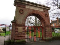
- This information is for the access point located on Barbourne Road.
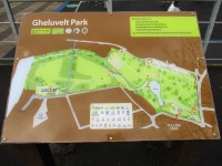
- There is an information board/map at this access point.
- There is step-free access at this access point.
- There is a gate which opens away from you (push).
- The gate is permanently held open.
- The width of the gap is 100cm.
Access Point (Barbourne Lane Children's Play Area)
-
Access Point
View
- This information is for the access point located on Barbourne Lane.
- There is not an information board/map at this access point.
- There is step-free access at this access point.
- There is a gate which opens away from you (push).
- The gate is difficult to open.
- The width of the gap is 100cm.
Access Point (Barbourne Road / Barbourne Lane Junction)
-
Access Point
View
- This information is for the access point located along Barbourne Road and Barbourne Lane junction.
- There is an information board/map at this access point.
- There is ramped/sloped access at this access point.
- There is no gate at this access point.
- The width of the gap is 100cm.
- There are bollards at this access point.
-
Ramp/Slope
View
- The ramp/slope is located immediately before the entrance.
- The gradient of the ramp/slope is slight.
Access Point (Tower Road Cycle Path)
-
Access Point
View
- This information is for the access point located along Tower Road.
- There is not an information board/map at this access point.
- There is step-free access at this access point.
- There is no gate at this access point.
- The width of the gap is 100cm.
Access Point (Lavender Road)
-
Access Point
View
- This information is for the access point located along Lavender Road.
- There is not an information board/map at this access point.
- There is ramped/sloped access at this access point.
- There is no gate at this access point.
- The width of the gap is 100cm.
-
Ramp/Slope
View
- The ramp/slope is located immediately after the entrance.
- The gradient of the ramp/slope is slight.
Access Point (Waterworks Road)
-
Access Point
View
- This information is for the access point located along Waterworks Road.
- There is not an information board/map at this access point.
- There is ramped/sloped access at this access point.
- There are bollards at this access point.
-
Ramp/Slope
View
- The ramp/slope is located within the entrance.
- The gradient of the ramp/slope is slight.
- There is a/are handrail(s) at the ramp.
Parks and Gardens
- The park or garden does have footpaths.
- The path(s) has a / have tarmac surface(s).
- The majority of the path(s) is / are wide enough for wheelchair users.
- There are slight slopes on the paths.
- There are bench seats situated along the paths for people to rest.
-
Comments
View
- There are a number of bridges in the park. All the bridges except Duck Bridge (shown in Photograph 6) are 150cm in width.
- The width of Duck Bridge is 112cm.
- Signage throughout the park is clear and there are frequent map boards with markings to show your location.
Battle of Gheluvelt and Word War 1 Interpretative Feature
- The Battle of Gheluvelt and Word War 1 Interpretative Feature is sited just inside the entrance at the Barbourne Road side of the park.
- There is an easy sloping path to the right inside the gate or an access point, with 10 clearly marked steps with handrails on both sides straight ahead. There is step free access from all other parts of the park.
- There are interpretative boards set at an accessible height and presented in a large, clear font.
Gheluvelt Splash Pad
- The splash pad is situated near the middle of the park. The ground slopes downwards and there are level places for people to sit.
- The surface is non slip and brightly coloured. There are no obstructions on the splash pad surface.
Play Areas
- There are play areas for toddlers and older children. There are tarmac paths around the areas and the play surface is a specialist rubberised material.
Riverside Conservation Park
- The entrance to the riverside conservation park is step-free.
- It is opposite to Tower Lane, on a cycle route.
- There is textured paving by the entrance to warn about cyclists.
Accessible Toilet (Lavender Road)
- Accessible toilet facilities are available.
-
Location and Access
View
- There is pictorial and written text signage on or near the toilet door.
- This accessible toilet is located in close proximity to the Lavender Road entrance.
- There is level access to this accessible toilet.
-
Features and Dimensions
View
- This is a shared toilet.
- A key is required for the accessible toilet.
- The key is a radar key.
-
Baby Change Facilities
View
- Baby change facilities are located within the venue.
- Baby change facilities are located within the accessible toilet.
Standard Toilet(s) (Lavender Road)
-
Availability and Location of Standard Toilets
View
- Standard toilet facilities are available.
-
Access to Standard Shared Toilet(s)
View
- The shared toilets that were surveyed are located in close proximity to the Lavender Road entrance.
- Inside the venue, there is level access to the shared toilet(s).
Barbourne Road and Barbourne Lane Public Toilets - Permanently Closed
- There are public toilets at the corner of Barbourne Road and Barbourne Lane.
- These toilets, as of January 2024, remain closed.


