

Access Guide
Introduction
- The following information describes the High Street area between the junction of Broadway/Coton Road and Grantchester Road via the High Street and Mill Way.
- The route is approximately 0.5 miles long (750m).
- The route takes approximately 10-15 minutes to walk on average dependant on the speed you walk.
- There is a bus stop located on Broadway.
- The surface of the paths is predominantly tarmac with some areas of gravel and cobbles on driveway thresholds.
- The potential hazards on this route include; narrow paths, uneven surfaces and slopes, cars coming out of driveways and parked cars on kerbs.
- The guide is split into the following sections:
- 1: Junction – Broadway and Coton Road and High Street
- 2: Coton Road to Vicarage Drive via High Street
- 3: Junction – High Street and Vicarage Drive
- 4: Vicarage Drive to High Street via High Street
- 5: Junction – High Street and High Street
- 6: High Street to Mill Way
- 7: Mill Way to Spring Lane
- 9: Junction – Mill Way and Spring Lane
- 9: Spring Lane to Grantchester Road via Mill Lane.
Getting Here
- By Car
- The village area surveyed is located mainly on the High Street and Mill Way which is approximately 1.3 miles from the M11 junction 12. There are direct links to London to the south and the A1 to the north. This is via the A603/Barton Road and Coton Road.
- By Bus
- There are bus stops located on Coton Road and Broadway with direct links to Fen Ditton, Arbury, Cambridge Railway Station, Madingley Road Park and Ride and several other locations.
- For Information on Stagecoach Buses see the following link:-
- https://www.stagecoachbus.com/about/east
- By Train
- Cambridge Railway Station is approximately 3 miles away from the northern end of the route where Broadway, Coton Road and the High Street meet.
- There are direct services to Norwich, Peterborough, Ely, London Liverpool Street, London Kings Cross, Royston, and Stevenage.
- There is step free access via lifts to all platforms at this station.
- Staff are available to assist with boarding via ramps.
- For more information on Thameslink and Great Anglia Railways see the following link:-
- https://www.thameslinkrailway.com/
- https://www.greateranglia.co.uk/.
Parking
- On Street Parking
- There is ample unmarked on street parking along the High Street, Mill Way, Coton Road, and Broadway.
- There are two blue badge spaces on the route near the junction of High Street and High Street.
1. Junction - Broadway and Coton Road and High Street
- There are no crossings at this junction.
- There is a dropped kerb leading into The Rupert Brooke pub car park.
- The roadway along Broadway/High Street is two way traffic.
- The roadway along Coton Road is two way traffic.
- The road surface is tarmac.
- The surface of the pathways is tarmac which are uneven in places.
- The Rupert Brooke Pub is on the junction of Broadway, Coton Road, and the High Street.
2. Coton Road to Vicarage Drive via High Street
- The distance from Coton Road to Vicarage drive is approximately 85 metres.
- There is a slight to steep uphill slope towards the High Street.
- The pathway is tarmac.
- The pathways on both sides vary in width and in places can be less than 120cm wide.
- There may be obstructions on the pavement including parked cars.
3. Junction - High Street and Vicarage Drive
- There is an uneven tarmac crossover covering the pathway into Vicarage Drive.
- The roadway on Vicarage Drive is gravel.
- The roadway on the High Street is tarmac.
- There may be obstructions such as parked cars on this junction.
4. Vicarage Drive to High Street via High Street
- The distance from Vicarage Drive to the High Street is approximately 87m.
- There is a slight to steep uphill slope towards the High Street.
- The pathway is tarmac.
- The roadway is tarmac.
- The pathway is undulated in places.
- There may be obstructions on the road including parked cars.
- There is bench seating available on the left hand side of the road near the junction of High Street and High Street.
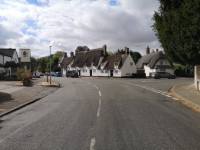
5. Junction - High Street and High Street
- There are no crossings at this junction.
- Traffic will come from all directions at this junction.
- There is a single blue badge space available.
- There is bench seating available on the left hand side of the road as shown in photographs 3 and 5.
6. High Street to Mill Way
- The distance from the High Street to Mill Way is approximately 160 metres.
- There is a slight to steep downhill slope towards Mill Way.
- The pathway is tarmac.
- The road surface is tarmac.
- After the parking bays the pathway on the right hand side of the road ends. The pathway continues on the left hand side of the road.
- There is a dropped kerb at the end of the pathway on the right hand side. There is no dropped kerb on the left hand side of the pathway.
- The pathway is narrow in places on both sides of the road and can be under 120cm in places.
- The pathway is undulated in places and there are inspection chambers, broken parts of tarmac/potholes and some crossings along the left hand side of the pathway.
- The road has two way traffic and crossing can be hazardous by the parking bays due to a blind corner by the church.
- There is on street parking on this part of the route which includes one blue badge space. There are no dropped kerbs by the parking bays.
7. Mill Way to Spring Lane
- The distance from the Mill Way to Spring Lane is approximately 51 metres.
- There is a slight to steep downhill slope towards Spring Lane.
- The pathway is tarmac.
- The road surface is tarmac.
- The pathway is undulated in places with broken parts of tarmac/potholes as shown in photographs 4 and 5.
8. Junction - Mill Way and Spring Lane
- The roadway on Mill Way is tarmac.
- The roadway on the Spring is tarmac.
- The pathway and roadway are undulated in places and the surface is broken/potholes in places.
- The is a slight to steep slope leading into Spring Lane.
- There is pedestrian access here to The Orchard Tea Garden.
9. Spring Lane to Grantchester Road via Mill Lane
- The distance from Spring Lane to Grantchester Road is approximately 350 metres.
- There is a slight to steep downhill slope towards Grantchester Road.
- The pathway is tarmac.
- The pathway is only on the left hand side.
- The hazards on the route include; undulating and narrow paths, vehicle access, and cobbles.
- There is both pedestrian and vehicle access to The Orchard Tea Garden. Traffic will be turning across the pathway as shown in photograph 8.
- There is on street parking near Spring Lane for approximately 6 cars.