

Access Guide
Introduction
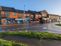
- Flitwick is a Market Town in Central Bedfordshire, located just to the north of the M1.
- This guide covers the main shopping area of Flitwick.
- The length of the route from one end to the other is 0.3miles (485m) in total.
- The route runs alongside a two way road throughout.
- There are bus stops in Steppingley Road and Coniston Road with buses operating towards Ampthill, Milton Keynes, Bedford, Luton and Leighton Buzzard.
- The nearest railway station is Flitwick, which is located on Steppingley Road and has services to Bedford, Luton and London.
- There is a taxi rank in Steppingley Road next to Flitwick Station.
- The street guide starts at Kendal Drive and follows Steppingley Road past Tesco on the right and Flitwick Station on the left.
- You will then turn right as you reach a roundabout at the junction with Dunstable Road / Coniston Road and Steppingley Road.
- You will now be on Coniston Road as you pass the Russell Centre to your left and then Tesco to your right.
- The route ends at Derwent Rise where it meets Coniston Road.
- The guide is divided into several sections with junctions.
- 1. Junction - Kendal Drive and Steppingley Road.
- 2. Kendal Drive to Roundabout; Coniston Road, Dunstable Road & Steppingley Road via Steppingley Road.
- 3. Junction - Roundabout; Coniston Road, Dunstable Road & Steppingley Road.
- 4. Roundabout; Coniston Road, Dunstable Road & Steppingley Road to Russell Centre via Coniston Road.
- 5. Junction - Russell Centre and Coniston Road.
- 6. Russell Centre to Derwent Rise via Coniston Road.
- 7. Junction - Derwent Rise and Coniston Road.
- The lighting along Steppingley Road and Coniston Road is mostly modern bright white lighting on grey/white concrete lamp posts.
- There is tactile paving and dropped kerbs as you approach many junctions on the route and there is one pedestrian crossing also.
- There are some uneven sections and easy slopes along the route.
- There are some raised drain covers and loose paving along the route.
Getting Here
- By Car:
- Steppingley Road is located approximately 3.4 miles from the M1 Junction 12, for links to Luton, Milton Keynes, Sheffield, London and Birmingham using the A1520 from Flitwick.
- Steppingley Road is in the town centre and runs past Tesco and Flitwick Station.
- Parking:
- There is no standard on-street standard parking or Blue Badge parking available throughout this guide.
- There are 2 car parks available in Steppingley Road, one next to Flitwick Station and one at Tesco.
- By Bus:
- There are several bus stops in Steppingley Road with buses to Luton, Toddington and Dunstable.
- These services are operated by Arriva Beds and Bucks.
- For more information on Arriva Beds and Bucks please click here
- By Train:
- Flitwick Station is in Steppingley Road, near Tesco.
- There is not step free access to all platforms.
- There is stepped access required for platforms 1, 2 and 3.
- There is a taxi rank outside the station.
- This station provides direct trains to Bedford, London St Pancras International, Central London, Gatwick and Brighton.
- The train operator for this station is ThamesLink.
- For more information on Flitwick Station please click here.
Parking
- Blue Badge Parking
- There is no nearby on-street Blue Badge parking available but there are Blue Badge parking bays available at three nearby car parks.
- Car Parks Nearby
- There are several public car parks in Steppingley Road. Two car parks are by the railway station, which are pay and display, and one at Tesco opposite the railway station, which is free but limited to a 3 hour maximum stay.
- There is a public car park in Coniston Road by the Russell Centre which is free but limited to a 2 hour maximum stay.
- There is no nearby on-street pay and display parking available as most of the roads in the area have double yellow lines.
1. Junction - Kendal Drive and Steppingley Road
- The pathways and road have a tarmac surface.
- There are dropped kerbs with tactile paving to cross Kendal Drive and Steppingley Road.
- Both Steppingley Road and Kendal Drive are two way roads with traffic busier on Steppingley Road and light traffic on Kendal Drive.
- Kendal Drive is on an easy slope downhill leading into Steppingley Road.
- Steppingley Road is level in both directions.
- There are two bollards to the side of the tactile paving at the Kendal drive crossing.
- Photograph 1 shows the junction from a distance.
- Photograph 2 and 3 show the crossing point on Steppingley Road.
- Photograph 4 and 5 show the crossing point over Kendal Drive.
2. Kendal Drive to Roundabout with Coniston Road, Dunstable Road and Steppingley Road via Steppingley Road
- The length of this section is approximately 161m.
- The road is tarmac throughout this section.
- The pathway is on both sides of a busy road with traffic coming from both directions.
- The pathway is a mixture of tarmac with block paving on both sides of the road throughout this section.
- The pathway is over 150cm in width throughout on the left hand side of the road with the pathway on the right hand side of the road mainly 100cm or under throughout.
- The pathway is level to begin with, then after approximately 10m becomes and easy slope uphill.
- There is a row of shops on the left pathway just after the route begins.
- These shops are Box of Delights, The Josephs Experience, In Stitches Fancy Dress, Bones Veterinary Clinic, Johnsons Dry Cleaners UK and The Tanning Salon.
- There is an entrance to Tesco on the right pathway after 15m of the route beginning.
- There is a crossing to cross Steppingley Road next to the Tesco entrance approach on the right pathway and by the row of shops on the left pathway. This crossing has dropped kerbs and tactile paving on both sides with an island in the middle. This crossing does cross a busy two way road as shown in photographs 3 and 4.
- As you continue along Steppingley Road for a further 12m you will approach the Tesco car park vehicle entrance on the right pathway, which has tactile paving and dropped kerbs as you cross it. The traffic comes from Steppingley Road only as you cross (your left) as shown in photographs 5.
- On the left pathway at the same point you will have to cross over the entrance to Flitwick Station and car park. This crossing has dropped kerbs and tactile paving as shown in photographs 8 and 9.
- A further 12m along is the station exit. There is a zebra crossing with dropped kerbs and tactile paving shown in photo 11.
- As you continue ahead for approximately 12m you will approach a pedestrian crossing that crosses Steppingley Road next to the taxi rank and Flitwick Station. This crossing has a push button that is 110cm in height on both sides of the road. This crossing has the red and green man symbols to let to know when to cross and bleeps when safe to cross. The crossing has dropped kerbs and tactile paving on both sides as shown in photographs 12 and 13.
- As you continue along Steppingley Road for a further 22m you will approach a roundabout which ends this section.
3. Junction - Roundabout; Coniston Road, Dunstable Road and Steppingley Road
- This junction is on a easy downhill slope into Steppingley Road, an easy uphill slope going into Dunstable Road over the bridge, an easy downhill slope going into Dunstable Road passing the Russell Centre and an easy downhill slope going into Coniston Road.
- The pathways at this junction are a mixture of tarmac and block paving and are over 120cm in width on all sides.
- There are dropped kerbs with no tactile paving crossing Steppingley Road as shown in photographs 2.
- There are no dropped kerbs or tactile paving crossing Dunstable Road as shown in photograph 6.
- There are dropped kerbs with no tactile paving crossing Coniston Road as shown in photographs 4 and 5.
- The road is tarmac at all sides of the roundabout.
- There is a pathway leading from this junction at the Dunstable Road side leading to The Swan Inn as shown in photograph 6.
4. Roundabout; Coniston Road, Dunstable Road and Steppingley Road to the Russell Centre via Coniston Road
- The length of this section is approximately 88m.
- The pathway is on both sides of a fairly busy road with traffic coming from both directions.
- The pathway is mainly tarmac with some block paving sections on both sides of the road throughout this section.
- The pathway is over 120cm in width throughout the section.
- The pathway is on an easy downhill slope from the exit of the roundabout.
- The road is tarmac throughout this section.
- As you continue along the pathway after leaving the roundabout you will approach after approximately 37m a crossing with dropped kerbs but no tactile paving to cross Coniston Road. The road here is fairly busy with traffic coming from both directions as shown in photographs 2 and 4.
- As you continue along Coniston Road after the crossing the pathway on both sides becomes an easy slope uphill and after a further 50m you will approach the junction for the Russell Centre and Coniston Road as shown in photograph 7.
5. Junction - Russell Centre and Coniston Road
- This junction is on an easy downhill slope into the Russell Centre, on an easy uphill slope going into Coniston Road towards Tesco and on an easy downhill slope going into Coniston Road towards the roundabout.
- The pathways at this junction are a mixture of tarmac and block paving and are over 120cm in width on all sides.
- There are dropped kerbs with no tactile paving to cross the entrance into the Russell Centre on the left pathway as shown in photographs 2 and 3.
- There are dropped kerbs with no tactile paving to cross Coniston Road as shown in photographs 4, 5 and 6.
- As you reach this junction from the left pathway you will see the Bumble Bee Public House ahead over the crossing and you will see the Russell Centre shops to the left which include the Co-op, Domino's, Coral, Connells, and Country Properties.
- There is parking for these shops on the left as shown in photographs 7 and 8.
6. Russell Centre to Derwent Rise via Coniston Road
- The length of this section is approximately 150m.
- The pathway is on both sides of a fairly busy road with traffic coming from both directions.
- The pathway is mainly tarmac with some block paving sections near the Tesco approach area on both sides of the road.
- The pathway is over 120cm in width throughout the section.
- The pathway is on an easy uphill slope with the roadway tarmac throughout.
- As you continue along the pathway after the junction with the Russell Centre, you will approach (after approximately 12m) a crossing with dropped kerbs, but no tactile paving to cross Coniston Road. The road here is fairly busy with traffic coming from both directions as shown in photographs 3 and 4.
- As you continue along Coniston Road the pathway on both sides is still an easy slope uphill and after a further 17m you will approach a side entrance leading to Flitwick Library on the left pathway.
- This crossing has dropped kerbs but no tactile paving with an easy downhill slope into the Library approach entrance as shown in photographs 7, 8, 9 and 10.
- At the same point on the right pathway you will approach Tesco. This is a pedestrian only approach and it is on an easy uphill slope. The pathway on this approach is block paving as shown in photographs 11, 12 and 13.
- As you continue along Coniston Road you will pass Flitwick Lounge Coffee House and a bus stop on the right pathway as shown in photographs 17 and 18.
- As you continue ahead you will approach the junction with Derwent Rise.
7. Junction - Derwent Rise and Coniston Road
- This junction is level into Coniston Road and has an easy uphill slope going into Derwent Rise.
- The pathways at this junction are tarmac and over 120cm in width on all sides.
- There are no dropped kerbs or tactile paving at this junction. The road here is tarmac.
- Photograph 1 shows the junction at a distance.
- Photographs 2 and 3 show the crossing over Derwent Rise on the right pathway from Coniston Road.
- Photograph 4 shows the crossing over Coniston Road just before Derwent Rise.
Public Toilets
- There are accessible and standard toilets available on Coniston Road at Tesco and Flitwick Library.
- There are several public houses along the route with standard toilet facilities for paying customers such as the Bumble Bee on Coniston Road and the Swan Inn on Dunstable Road.