Access Guide
Introduction
- High Street Whitton is located just to the west of Twickenham, close to the A316.
This guide covers the main shopping area of High Street Whitton.
This runs from the junction with Nelson Road in the north, to the junction with Bridge Way and Constance Road in the south.
This is approximately 0.2 miles (320m) and takes around 5 minutes to walk.
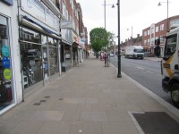
The shopping area is generally level or with slight slopes.
Footpaths are of concrete paving slabs.
The road surfaces are tarmac with tactile paving at all crossing points.
There are opportunities to sit and rest.
Getting Here
- By Car:
- High Street Whitton is located approximately 1 mile from the A316, using Percy Road from the south or Hospital Bridge Road and Nelson Road from the north.
- High Street Whitton runs from north to south.
- At the north end it joins with Nelson Road.
- At the south end it joins with Bridge Way and Constance Road.
- Parking:
- There are short stay car parks to the rear of Iceland and Lidl and limited on-street parking.
- By Bus:
- There is a bus stop on either side of High Street Whitton which serve many routes to the surrounding areas.
- By Train:
- Whitton Station is located to the south of High Street Whitton, close to Bridge Way.
- There is step-free access to the platforms at this station.
Parking
- High Street Car Parks:
- There are two Blue Badge parking bays located within the High Street car park to the rear of Iceland.
- The bays are 360 x 600cm wide.
- There is no signage but there are clear markings as shown in photograph 2.
- Parking is limited to 2 hours for Blue Badge holders in this area.
- There are also standard parking bays in this car park, limited to 2 hours as shown in photographs 3 and 4.
- The Nelson Road car park is located to the rear of Lidl.
- There are two Blue Badge parking bays in this car park.
- The bays are 360 x 600cm wide.
- There is clear signage and markings as shown in photograph 6.
- Parking is free for Blue Badge holders for a maximum stay of 3 hours.
- There are also standard parking bays in this area, limited to 3 hours with no return within 1 hour as shown in photographs 7, 8, 9 and 10.
- Photographs 11 and 12 show the access point from High Street to both car parks.
- On-street Parking:
- There are four on-street Blue Badge bays on both sides of High Street.
- There is one on the south side, outside the Post Office.
- There are three on the north side outside Barclays Bank and the Additional Aids shop.
- There are plenty of standard on-street bays on both sides of High Street.
- Blue Badge holders may park in any of the bays for an unlimited period.
- There are no dropped kerbs from the bays to the pavement.
Junction - Nelson Road with High Street
- Nelson Road and High Street Whitton meet at a small roundabout.
- Footpaths in this area are concrete paving slabs or block paving.
- There are four zebra crossings with dropped kerbs and tactile paving.
- Two of the crossings have a central refuge at the crossing.
High Street East - Nelson Road to Bridge Way
- There are railings between the footpath and the road close to the junction.
- The footpaths are generally level with some slight slopes close to the road.
- There may be tables and chairs on the pavement outside cafés.
- There are cycle racks and poles for road signs set into the pavement.
- There may also be A-board signs outside shops.
- There is bench seating close to the pedestrian crossings.
- There is the Whitton High Street bus stop located along the High Street which serves routes 110 and H22. This is situated outside 45 High Street Whitton.
Controlled Crossing Point near to Costa/Tesco Express
- There is a push button pedestrian crossing with visual signals.
- The right-hand push button is fitted with a rotating cone for visually impaired users.
- There are level kerbs and tactile paving on both sides of the road at this crossing.
Crossing Point - Bridge Way
- The crossing at Bridge Way has level kerbs with tactile paving.
- The surface of the pavement is concrete slabs.
- The surface of the road is tarmac.
High Street West - Constance Road to Nelson Road
- The footpaths are generally level with some slight slopes close to the road.
- There may be tables and chairs on the pavement outside cafés.
- There are cycle racks and poles for road signs set into the pavement.
- There may also be A-board signs outside shops.
- There is bench seating close to the pedestrian crossings.
- There is Whitton High Street Bus stop outside 38 Whitton High Street which serves routes 110 and H22.
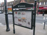
- There is a town map outside 38 Whitton High Street.
- There are railings between the footpath and the road close to the junction.
Crossing Point - Constance Road
- The crossing at Constance Road has level kerbs with tactile paving.
- The surface of the pavement is concrete slabs.
- The surface of the road is tarmac.
Crossing Point - Tranmere Road
- The crossing at Tranmere Road has level kerbs with tactile paving.
- The surface of the pavement is concrete slabs.
- The surface of the road is tarmac.
Controlled Crossing Point near to Tranmere Road
- There is a push button pedestrian crossing with visual signals.
- The right-hand push button is fitted with a rotating cone for visually impaired users.
- There are level kerbs and tactile paving on both sides of the road at this crossing.
Access Guides Available For (Whitton Shopping Area)
-
Shopping
View
- The Co-operative Funeralcare - To view the access guide please click here (new tab).
- Superdrug - To view the access guide please click here (new tab).
- Additional Aids Mobility - To view the access guide please click here (new tab).
- Cancer Research UK - To view the access guide please click here (new tab).
- Cavan Bakery - To view the access guide please click here (new tab).
- Greggs - To view the access guide please click here (new tab).
- Sainsbury's Local - To view the access guide please click here (new tab).
- YMCA - To view the access guide please click here (new tab).
- Eating and Drinking View
- Other Services View


