
Access Guide
Overview
- This Access Guide is about the shopping and leisure area of Duke of York Square.
This guide was created in December 2021 and updated April 2023.
The area may have changed since the guide was created. - Duke of York Square is located on the south side of King's Road, to the west of Sloane Square.
The area was converted from historic buildings and is a destination for boutique stores and a range of restaurants.
Other facilities include the Saatchi Art Gallery and a running track.
The open square may be used for farmers' markets and cultural events, as well as outside dining. - The area is pedestrianised and is generally level with even stone paving.
- There is fixed seating in the paved areas.
There may also be temporary café seating in this area. - The main ways to get to Duke of York Square are by train, tube, bus and taxi.
Sloane Square underground station is about 120m east of Duke of York Square.
The nearest underground station with step-free access is Victoria.
There are bus stops nearby on both sides of King's Road. - There is no parking in Duke of York Square.
There may be limited pay-by-phone on-street parking bays in some side roads. - There is a standard automatic toilet in Sloane Square near to the underground station, but this was out of order at the time of our survey.
- To view the Access Guide for Sloane Square please click here (new tab)..
- To view the Access Guide for King's Road please click here (new tab)..
Getting Here
-
By Bus
View
- There is a bus stop on the south side (westbound) of Kings' Road - Duke of York Square stop G.
The eastbound stop on the north side is stop E Cadogan Gardens, outside the Peter Jones store.
Both stops serve routes 11, 19, 22, 211 and night buses N11, N19 and N22,
Bus stop G also serves route 319.
All London buses have ramped access and dedicated space for wheelchair users. - For more information on London buses (Transport for London) please click here (opens new tab).
- There is a bus stop on the south side (westbound) of Kings' Road - Duke of York Square stop G.
-
By Underground
View
- The nearest station with step-free access is Victoria (District, Circle and Victoria Lines).
This is about 1.6km (1 mile) from Duke of York Square.
Bus routes 11 and 21 connect Victoria Station with King's Road, near to Duke of York Square.
The nearest underground station is Sloane Square, served by the District and Circle lines.
This station does not have step-free access. - For more information on London Underground services please click here (opens new tab).
- The nearest station with step-free access is Victoria (District, Circle and Victoria Lines).
-
By Train
View
- The nearest railway station is London Victoria.
- London Victoria Station has step-free access to all platforms and staff available to assist with ramps between the platform and the train.
- For more information on access and facilities at London Victoria Station please click here (opens new tab).
-
By Road
View
- A3217 - King's Road connects with Sloane Square to the east.
To the west if becomes the A308 New King's Road towards Putney.
King's Road is outside the Central London Congestion Charge Zone.
The area is in the Ultra Low Emission Zone (charges apply at all times for non-compliant vehicles). - For more information on driving in London please click here (opens new tab).
- Parking in the area is very limited and visitors are encouraged to use public transport.
There are standard on-street pay-to-park bays in some of the side roads.
There are 2 on-street Blue Badge bays in Lincoln Street, opposite Duke of York Square, and a single Blue Badge bay further west in Bywater Street.
There is an underground NCP car park east of Sloane Street in Cadogan Place.
The website mentions that it has Blue Badge bays.
The pedestrian access to/from the car park is very steep.
There is also a car park in Pavilion Road to the west of Sloane Street.
This car park does not have disabled access. - For more information on the Blue Badge scheme and parking in London please click here (opens new tab).
- For more information on disabled parking in Kensington and Chelsea please click here (opens new tab).
- London Black Cabs can be hailed in any location or summoned by phone.
- A3217 - King's Road connects with Sloane Square to the east.
-
By River
View
- 6 TfL River Bus routes run from 22 piers between Putney and Woolwich.
The nearest accessible pier is Millbank.
This is about 400m from bus routes on Vauxhall Bridge Road that connect with Sloane Square.
There is step-free access onto the river buses, except at 3 piers.
Please see the TfL website for details. - For more information on London River Bus services please click here (opens new tab).
- 6 TfL River Bus routes run from 22 piers between Putney and Woolwich.
-
By Air
View
- The nearest airports to central London are London City Airport, London Gatwick and London Heathrow.
London City Airport is connected to the centre by the Docklands Light Railway (DLR) to Bank, or Tower Gateway with interchanges to the rail and underground network at Canning Town and Stratford.
From Gatwick Airport there are fast trains connecting to London Bridge Station.
Heathrow Airport is connected by fast trains to Paddington Station and is also on the Piccadilly underground line. - For more information on travelling to London by air please click here (opens new tab).
- The nearest airports to central London are London City Airport, London Gatwick and London Heathrow.
-
Useful Links
View
- Please use the TfL journey planner for details of the most suitable route.
The planner can be filtered by options such as step-free routes or maximum walking distances. - To view the web page described above click here (opens in new tab).
- The TfL website has links to the TfL accessibility guides, including large print maps and audio guides to order or download.
- To view the web page described above click here (opens in new tab).
- Please use the TfL journey planner for details of the most suitable route.
Access Point (King's Road/Sloane Square)
-
Access Point
View
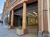
- This covered access point is located at the east end of King's Road, near to Sloane Square.
It leads to the open shopping area of Duke of York Square. - There is ramped/sloped access at this access point.
- There is open access.
- There is an information board/map at this access point.
- The map and information sign is after the covered section, at the entrance to the open square.
- There may be some shop displays at the side of the walkway.
- This covered access point is located at the east end of King's Road, near to Sloane Square.
-
Ramp/Slope
View
- The ramp/slope is located within the covered area.
- The gradient of the ramp/slope is slight.
- The ramp/slope is permanent.
- There is a level landing at the top of the ramp/slope.
Access Point (King's Road, opposite Cadogan Gardens)
-
Access Point
View
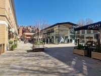
- This open access point is a walkway between the Castore and Space NK Apothecary buildings, located on King's Road, opposite Cadogan Gardens.
- There is step-free access at this access point.
- There is open access.
- There is an information board/map at this access point.
- The map signpost is at the entrance to the walkway.
- There is a row of lamppost, bollards and a sculpture along the centre of the walkway.
Just before the walkway opens into the square, there is a large planter in the centre of the walkway that has bench seating around it.
Access Point (King's Road, opposite Blacklands Terrace)
-
Access Point
View
- The open square has a long frontage to King's Road, opposite Blacklands Terrace and Lincoln Street, that generally has level access.
Most of the frontage has wide clear openings between trees, stone block seating or large planters.
The central section has a row of bollards.
At the far western end there is a short ramp. - There is ramped/sloped access at this access point.
- There is open access.
- There are bollards at this access point.
- The bollards do not contrast visually with the paving.
- The minimum width between the bollards is 120cm.
- There is an information board/map at this access point.
- There is a map signpost on King's Road, to the right of the bollards.
- The open square has a long frontage to King's Road, opposite Blacklands Terrace and Lincoln Street, that generally has level access.
-
Ramp/Slope
View
- The ramp/slope is located at the far western end of the square, alongside the building.
- The gradient of the ramp/slope is slight.
- The ramp/slope is permanent.
- There is a level landing at the top of the ramp/slope.
- There is a/are handrail(s) at the ramp.
- The handrail(s) is/are on the right going up.
-
Comments
View
- There is tactile paving intended to warn of steps at the top of the ramp.
General Accessibility
-
Paths and Pavements
View
- There is step free access around Duke of York Square.
The surface of the paths are stone paving. - At the rear of the open area there is a tall curved wall, which gives access to the Saatchi Gallery and the running track.
There is a step-free route with a very slight slope to the right of the wall.
The walkway is between wide black metal gates that are held open .
There is an open archway in the brick wall as an alternative route.
There are 2 medium steps at the archway that are no clearly marked or have tactile paving .
There are no handrails at the steps. paving and do not have contrasting step nosings.
There are no handrails at the steps (photographs 11 and 12). - The shops and restaurants in the area have level or step-free access.
.
- There is step free access around Duke of York Square.
-
Street Furniture and Features
View
- Within the shopping area there are bench seats around large planters and also benches without backrests or armrests.
Some of the restaurants have outside dining areas. - In the open area, there are bench seats around large trees.
There are also stone walls and blocks that are used for seating.
Some of these are low and have poor contrast with the paving. - Some of the cafes and restaurants have their own outside seating area.
There may also be seating and large umbrellas in the open area of the square .
- Within the shopping area there are bench seats around large planters and also benches without backrests or armrests.
-
Maps and Signage
View
- There are Duke of York Square information posts all the access points to the square and at the junctions of routes within the shopping area.
-
Public Transport
View
- The nearest bus stops are on King's Road.
Bus stop G, westbound, has a shelter with seats.
Bus stop E, eastbound, does not have a shelter or seats, but there is some weather protection from the canopy of the Peter Jones store.
- The nearest bus stops are on King's Road.