
Access Guide
Overview
- This Access Guide is about the garden of Sloane Square and the roads that surround it.
This guide was created in December 2021 and updated April 2023.
The area may have changed since the guide was created. - Famous landmarks are the Peter Jones department store on the west side of the square, and the Royal Court Theatre on the east side.
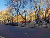
- Pavements are generally wide and level, but can be congested at busy times.
There are two or three lanes of traffic moving one-way around the square.
There are controlled crossing points such as traffic lights and zebra crossings at the side roads connecting with the square, except for the area outside Sloane Square underground station. - There are Legible London map signs outside the underground station and on the south side of the square near to Lower Sloane Street.
- There is fixed seating in the paved area in the centre of the square.
There may also be temporary café seating in this area. - The main ways to get to Sloane Square are by train, tube, bus and taxi.
Sloane Square underground station is at the south-east corner of the square.
The nearest underground station with step-free access is Victoria.
There is a bus stop on the south side of the square and near to the square in Symons Street. - There are no parking bays in Sloane Square.
There may be limited pay-by-phone on-street parking bays in some side roads.
There are public car parks nearby in Cadogan Place and Pavilion Road. - To view the Access Guide for Sloane Street please click here (new tab)..
- To view the Access Guide for King's Road please click here (new tab)..
- To view the Access Guide for Duke of York Square please click here (new tab)..
Getting Here
-
By Bus
View
- There is a bus stop on the south side of Sloane Square.
Bus routes 19, 22, 319 travel south and C1 travels west.
It is also served by night bus routes N19 and N22.
All London buses have ramped access and dedicated space for wheelchair users. - For more information on London buses (Transport for London) please click here (opens new tab).
- There is a bus stop on the south side of Sloane Square.
-
By Underground
View
- The nearest station with step-free access is Victoria (District, Circle and Victoria Lines).
This is about 1.6km (1 mile) from Sloane Square.
Bus route C1 connects Victoria Station with Sloane Square.
Sloane Square underground station is served by the District and Circle Lines.
This station does not have step-free access. - For more information on London Underground services please click here (opens new tab).
- The nearest station with step-free access is Victoria (District, Circle and Victoria Lines).
-
By Train
View
- The nearest railway station is London Victoria.
- London Victoria Station has step-free access to all platforms and staff available to assist with ramps between the platform and the train.
- For more information on access and facilities at London Victoria Station please click here (opens new tab).
-
By Road
View
- Sloane Square connects with A3217 - King's Road/Cliveden Place to the west and east.
To the north and south it connects with A3216 - Sloane Street and Lower Sloane Street.
Sloane Square is outside the Central London Congestion Charge Zone.
The area is in the Ultra Low Emission Zone (charges apply at all times for non-compliant vehicles). - For more information on driving in London please click here (opens new tab).
- Parking in the area is very limited and visitors are encouraged to use public transport.
There is an underground NCP car park east of Sloane Street in Cadogan Place.
The website mentions that it has Blue Badge bays.
The pedestrian access to/from the car park is very steep.
There is also a car park in Pavilion Road to the west or Sloane Street.
This car park does not have disabled access.
There are standard on-street pay-to-park bays in some of the side roads. - For more information on the Blue Badge scheme and parking in London please click here (opens new tab).
- London Black Cabs can be hailed in any location or summoned by phone.
- Sloane Square connects with A3217 - King's Road/Cliveden Place to the west and east.
-
By River
View
- 6 TfL River Bus routes run from 22 piers between Putney and Woolwich.
The nearest accessible pier is Millbank.
This is about 400m from bus routes on Vauxhall Bridge Road that connect with Sloane Square.
There is step-free access onto the river buses, except at 3 piers.
Please see the TfL website for details. - For more information on London River Bus services please click here (opens new tab).
- 6 TfL River Bus routes run from 22 piers between Putney and Woolwich.
-
By Air
View
- The nearest airports to central London are London City Airport, London Gatwick and London Heathrow.
London City Airport is connected to the centre by the Docklands Light Railway (DLR) to Bank, or Tower Gateway with interchanges to the rail and underground network at Canning Town and Stratford.
From Gatwick Airport there are fast trains connecting to London Bridge Station.
Heathrow Airport is connected by fast trains to Paddington Station and is also on the Piccadilly underground line. - For more information on travelling to London by air please click here (opens new tab).
- The nearest airports to central London are London City Airport, London Gatwick and London Heathrow.
-
Useful Links
View
- Please use the TfL journey planner for details of the most suitable route.
The planner can be filtered by options such as step-free routes or maximum walking distances. - To view the web page described above click here (opens in new tab).
- The TfL website has links to the TfL accessibility guides, including large print maps and audio guides to order or download.
- To view the web page described above click here (opens in new tab).
- Please use the TfL journey planner for details of the most suitable route.
General Accessibility
-
Paths and Pavements
View
- The paths on the roads surrounding the square are generally wide and level. They are often congested, particularly near the underground station.
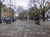
- The central garden of Sloane Square is paved.
There are some uneven areas near the large trees.
The area can be noisy because of the surrounding traffic.
The garden includes the Venus Fountain and the Chelsea War memorial.
-
Street Furniture and Features
View
- The garden square has fixed bench seats with backrests and armrests.
There may also be temporary bars and cafés in the area.
Seating may be located on the paved area. - There are cycle racks and also parking areas for app-hire cycles and scooters around the square. There are cycle racks located outside the underground station in Holbein Place.
- There are kiosks on the pavement near to Sloane Square underground station that may cause an obstruction.
There may also be tables and chairs outside venues on the north and east sides of the square.
- The garden square has fixed bench seats with backrests and armrests.
-
Maps and Signage
View
- There are Legible London map signs outside the underground station and on the south side of the square near to Lower Sloane Street.
-
Public Transport
View
- Bus stop H is on the south side of the square between Holbein Place and Lower Sloane Street .
The bus stop has a shelter with a perching seat.
There is no bus arrival display at this stop. - There are no taxi ranks in the area, although many taxis wait around the square and can be hailed in person or using a phone app.
- The entrance to Sloane Square underground station has step-free access from the street but all platforms are reached by stairs or escalators.
- Bus stop H is on the south side of the square between Holbein Place and Lower Sloane Street .
Main Pedestrian Crossing(s) (Access to Sloane Square Garden - North Side)
- From the North side of the Sloane Square, near to Sloane Street to the Central Square.
There is a zebra crossing.
The zebra crossing has dropped kerbs with tactile paving on both sides of the road. - There is a central refuge that is level and marked by tactile paving.
This allows the road to be crossed in 2 stages. - The zebra crossing is clearly marked on the grey tarmac road.
- The traffic on both sides of the central refuge is travelling eastbound (clockwise) around the square.
Main Pedestrian Crossing(s) (Lower Sloane Street and Access to Garden Square South Side)
- Lower Sloane Street is on the south side of Sloane Square.
There is a direct crossing of Lower Sloane Street at this junction.
There are dropped kerbs with tactile paving on both sides of the road, but the tactile paving is very worn in places.
There is no tactile paving at the crossing point on the central garden. - There is also a triangular island between the west and east sides of Lower Sloane Street and the central garden square.
The traffic lights are phased to make this crossing in 2 stages.
The island does not have visual contrast or tactile paving. - The road surface is grey tarmac.
- Traffic in Sloane Square is one-way, westbound (clockwise).
There is painted floor signage to indicate the direction of traffic at the crossing between the island and the garden square.
There is two-way traffic entering and leaving Lower Sloane Street.
Side Street Crossings
- Vehicles travelling south leave Sloane Square outside the underground station at Holbein Place.
The path is level with the crossing point over the road and could appear to be a pedestrian area.
Where vehicles cross, there are some tactile markings to warn pedestrians, but these do not extend the full width of the area . - There is two-way traffic at the junction with King's Road.
There is a push-button pedestrian crossing with dropped kerbs and tactile paving.
There are visual but not audible signals and there is a countdown timer.
The control boxes have rotating cones underneath to show to safe time to cross. - Vehicles travelling east enter Sloane Square at Symons Street, north of the Peter Jones store.
There is a zebra crossing to cross Symons Street.
The crossing has dropped kerbs with tactile paving, but there is a lip at the kerb on the north side. - Due to the ongoing roadworks taking place on Sloane Street, there is a temporary signal crossing point. There is clear signage directing pedestrians to the temporary crossing point. There are dropped kerbs without tactile paving to access the crossing point. There are visual but not audible signals. br> The control boxes have rotating cones underneath to show to safe time to cross.
- There is one-way traffic heading north at the junction with Sedding Street.
This is a school street, which may be closed to traffic by barriers at the start and end of the school day.
There are dropped kerbs on both sides of the road, but the west side does not have tactile paving. - There is two-way traffic at the junction with Sloane Square/ Cliveden Place at the north-east corner of the square.
There is a zebra crossing with dropped kerbs and tactile paving.
The central refuge has a level surface and tactile paving and allows the road to be crossed in 2 stages.