
Access Guide
Overview
- This Access Guide covers the pedestrianised area of Pavilion Road. between Symons Street and Cadogan Gardens with local shops, cafés and outside seating.
This is a distance of about 150m (500ft).
This guide was created in December 2021 and updated in April 2023.
The area may have changed since the guide was created. - There is seating within the pedestrianised section.
- .
- The main ways to get to Pavilion Road are by train, tube, bus and taxi.
Knightsbridge underground station is near the northern end of Pavilion Road, off Sloane Street.
Sloane Square underground station is near the southern end of the street.
These stations do not have step-free access.
The nearest underground stations with step-free access are Green Park and Victoria.
There are no bus routes in Pavilion Road.
There nearest bus stops are in Symons Street and Sloane Street. - There is limited pay-by-phone on-street parking in some sections of Pavilion Road and nearby side roads.
There are public car parks in Pavilion Road and nearby in Cadogan Place. - There are no public toilets in Pavilion Road.
There is a standard automatic toilet in Sloane Square, but this was out of order at the time of the survey. - To view the Access Guide for Sloane Street please click here (new tab)..
- To view the Access Guide for Sloane Square please click here (new tab)..
Getting Here
-
By Bus
View
- Bus stop B on Symons Street is near the southern end of Pavilion Road and Sloane Square.
This is served by route 319 eastbound.
North of this, the nearest bus stops are the 3 on each side of Sloane Street.
Bus routes 19, 22, 137, 452 and C1 travel in both directions.
Sloane Street is also served by night bus routes N19, N22 and N137.
All London buses have ramped access and dedicated space for wheelchair users. - For more information on London buses (Transport for London) please click here (opens new tab).
- Bus stop B on Symons Street is near the southern end of Pavilion Road and Sloane Square.
-
By Underground
View
- The nearest stations with step-free access are Green Park (Jubilee Line, Piccadilly and Victoria lines) and Victoria (District, Circle and Victoria Lines).
Both stations are over 1km from Pavilion Road.
Bus routes 19 and 22 connect Green Park Station with Sloane Street.
The nearest underground stations to Pavilion Road are Knightsbridge (Piccadilly Line) and Sloane Square (District and Circle Lines).
These stations do not have step-free access. - For more information on London Underground services please click here (opens new tab).
- The nearest stations with step-free access are Green Park (Jubilee Line, Piccadilly and Victoria lines) and Victoria (District, Circle and Victoria Lines).
-
By Train
View
- The nearest railway station is London Victoria.
- London Victoria Station has step-free access to all platforms and staff available to assist with ramps between the platform and the train.
- For more information on access and facilities at London Victoria Station please click here (opens new tab).
-
By Road
View
- Pavilion Road runs north-south and is parallel and to the west of Sloane Street (A3216).
There are several east-west roads such as B319 Pont Street that connect to Sloane Street.
Sloane Street connects with A3217 - King's Road/Cliveden Place to the south at Sloane Square.
To the north it connects with A4 - Brompton Road/Knightsbridge.
Pavilion Road is just outside the Central London Congestion Charge Zone, which starts nearby on Knightsbridge to the east (charges apply Monday - Friday 07:00 -18:00).
The area is in the Ultra Low Emission Zone (charges apply at all times for non-compliant vehicles). - For more information on driving in London please click here (opens new tab).
- Parking in the area is very limited and visitors are encouraged to use public transport.
There is limited on-street pay-by-phone parking in some sections of Pavilion Road and nearby side roads.
There is one on-street Blue Badge parking bay, at the junction with Herbert Crescent.
There is a public covered/underground car park in Pavilion Road.
This car park does not have disabled access.
There is also an underground NCP car park east of Sloane Street in Cadogan Place.
The website mentions that it has Blue Badge bays.
The pedestrian access to/from the car park is very steep. - For more information on the Blue Badge scheme and parking in London please click here (opens new tab).
- For more information on disabled parking for visitors in Kensington and Chelsea please click here (opens new tab).
- London Black Cabs can be hailed in any location or summoned by phone.
- Pavilion Road runs north-south and is parallel and to the west of Sloane Street (A3216).
-
By River
View
- 6 TfL River Bus routes run from 22 piers between Putney and Woolwich.
The nearest accessible pier is Westminster.
This is close to Westminster Underground Station on the Jubilee Line which connects to Green Park Station.
There is step-free access onto the river buses, except at 3 piers.
Please see the TfL website for details. - For more information on London River Bus services please click here (opens new tab).
- 6 TfL River Bus routes run from 22 piers between Putney and Woolwich.
-
By Air
View
- The nearest airports to central London are London City Airport, London Gatwick and London Heathrow.
London City Airport is connected to the centre by the Docklands Light Railway (DLR) to Bank, or Tower Gateway with interchanges to the rail and underground network at Canning Town and Stratford.
From Gatwick Airport there are fast trains connecting to London Bridge Station.
Heathrow Airport is connected by fast trains to Paddington Station and is also on the Piccadilly underground line. - For more information on travelling to London by air please click here (opens new tab).
- The nearest airports to central London are London City Airport, London Gatwick and London Heathrow.
-
Useful Links
View
- Please use the TfL journey planner for details of the most suitable route.
The planner can be filtered by options such as step-free routes or maximum walking distances. - To view the web page described above click here (opens in new tab).
- The TfL website has links to the TfL accessibility guides, including large print maps and audio guides to order or download.
- To view the web page described above click here (opens in new tab).
- Please use the TfL journey planner for details of the most suitable route.
General Accessibility (Pavilion Road Pedestrianised Shopping Areas)
-
Paths and Pavements
View
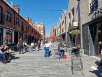
- The pedestrianised area of Pavilion Road is located between Symsons Street and Cadogan Gardens.
There are a number of shops, cafes and restaurants located along this section of Pavilion Road.
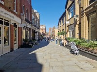
At the access to Pavillion Road from Symsons Street there are bollards with a good contrast.
The area has stone paving that is even.
There is a long slight slope located next to the Heidi Klein Shop.
There are bollards with good contrast at the bottom of the slope where Pavilion Road meets Cadogan Gardens.
There is a bench seating available.
. - After the bollards at Cadogan Gardens, the pavement continues level without a kerb but there may be some vehicles crossing this area.
- From here up to the north section of Cadogan Gardens is also mostly pedestrianised.
The pedestrian section is closed at each end by large planters with seating around them.
The paving in this area is even.
There is a clear central walkway, but there are usually tables and chairs for outside dining on both sides of the path.
The shops and cafés in this area have step-free access.
- The pedestrianised area of Pavilion Road is located between Symsons Street and Cadogan Gardens.
-
Street Furniture and Features
View
- Both of these areas are likely to have planters and A-board signs outside the businesses, as well as pavement tables and chairs.
- At the northern end of the shopping area, after the large planter, there is an area of cycle racks.
There are also 2 short-stay parking bays and there may be other vehicles making deliveries.