
Access Guide
Introduction
-
Comments
View
- The tour meets and begins in The Royal Concert Hall on Killermont Street/Buchanan Street and finishes in King Tut’s Wah Wah Hut on St Vincent Street.
- This is a guided tour from the Royal Concert Hall along Renfrew Street and Sauchiehall Street visiting the CCA (Centre for Contemporary Arts) and Nice N Sleazy venues before heading to and completing the tour in Kings Tut’s, over approximately 1 mile in total.
- The group tour is scheduled every Saturday afternoon (except under extreme weather conditions) and takes around 2 hours to complete. Private tours are available which can be fully customised if more flexibility is required. If coming from the earlier Merchant City tour’s end point in King Street, the Royal Concert Hall is approximately 1 mile away, with around an hour to get between points.
- This tour has some long easy slopes in places, with shorter steep downhill slopes towards the end point near St Vincent Street. Less steep routes can be taken towards the end point and tour guides will know which streets are best to take there. The pavements have a range of surfaces including tarmac, concrete, block paving and paving slabs with some surfaces uneven in places. Nearly all road crossing points offer dropped kerbs, and many are at pedestrian crossings which offer tactile paving on both sides.
- The tour is near the city centre and busy areas but was planned to keep away from major thoroughfares as much as possible by mainly sticking to quieter streets. There are various on-street talking and viewing points throughout the tour. Guests are encouraged to bring any required refreshments with them, although guides are use to people occasionally dropping into shops along the route and catching up with the tour.
- There are seating areas inside all four venues on the tour, outside the Royal Conservatoire of Scotland, and all along Sauchiehall Street.
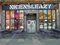
- Step-free access to the Royal Concert Hall is via the Killermont Street main entrance lift. At CCA (Centre for Contemporary Arts) there is level access via the main entrance and a lift to the first floor to the Saramago bar level, bypassing the steep slope and steps used for the side entrance here. Nice N Sleazy has step-free seating available in the bar with space available for wheelchair users to avoid the tour using the downstairs area, which may offer more space if steps are possible for all attending.
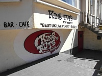
- King Tut’s has steps at the entrance for which they have a portable ramp available to bypass. The front bar is accessible step-free, but there are steps if going into the rear music performance hall.
- There are standard toilets available in all four venues visited on this tour, and accessible toilet facilities within the Royal Concert Hall and CCA (Centre for Contemporary Arts). Please refer to the separate venue guides for further details.
Opening Times
- Please contact the venue for details of opening times and Opening times for the venue vary according to bookings/events taking place.
Location
- There is a bus stop within 150m (164yds) of the venue.
- The nearest National Rail station is Queen Street.
- The nearest underground station is Buchanan Street.
Parking
- The venue does not have its own car park.
-
Public Car Parks
View
- There is a car park for public use within 200m (approx).
- The name of the car park is Buchanan Galleries.
- The car park is located of Killermont Street.
- There is a/are Blue Badge parking bay(s) available within the car park.
-
On Street Blue Badge Parking
View
- On street marked Blue Badge bays are not available.
-
On Street Standard Parking
View
- Clearly signed and / or standard marked parking bays are not available.
-
Drop-off Point
View
- There is not a designated drop off point.
-
Comments
View
- Concert Square car park is also close to the starting point.
- At the finishing point there is standard parking in front of the venue at King Tut's on St Vincent Street.
- There are further car parks near the Sauchiehall Street venues at Charing Cross Car Park, or Cambridge Street Car Park nearer the start.
Royal Concert Hall to Sauchiehall Street
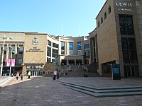
- The tour meets in the spacious ground floor foyer of Glasgow Royal Concert Hall (which has level access via lift from the main entrance on Killermont Street), opposite Buchanan Bus Station.
- For full details on the Royal Concert Hall please refer to the separate access guide.
- The tour exits the Royal Concert Hall on Killermont Street to the left towards West Nile Street, where the pedestrian crossings are used to cross to the side diagonally opposite. Killermont Street becomes Renfrew Street beyond West Nile Street to the west.
- Renfrew Street is followed across the lane of Renfrew Court until the Renfield Street crossroads, diagonally opposite the Pavilion Theatre. At this point the tour may turn right up Renfield Street to the quieter area outside The Flying Duck. If it isn’t too busy or noisy the pedestrian crossings are used to cross over to the Pavilion Theatre. Renfrew Street has a concrete paving surface on this side which is followed until the Hope Street crossroads diagonally opposite the Royal Conservatoire of Scotland.
- The pedestrian crossings are used to cross over to the Royal Conservatoire where there is some seating available on the wall during the talk there. This side of Renfrew Street now has a block paving surface which is followed along and across Hill Street to the Cambridge Street crossroads. Both roads are crossed using the pedestrian crossing to begin climbing the slight hill on the diagonally opposite side.
- There is an easy incline up to the next junction with Rose Street which is approximately 90m away so assistance may be required. Turning left onto Rose Street at the Glasgow Film Theatre there is then an easy slope down to the pedestrianised section of Sauchiehall Street which has a block paving surface.
Sauchiehall Street to CCA (Centre for Contemporary Arts)
- At the far side of the pedestrianised section of Sauchiehall Street the pedestrian crossing to the right is used to cross Rose Street over to the non-pedestrianised section of Sauchiehall Street. The wide pavements here have a paving slab surface and there are benches at regular intervals if resting areas are required.
- There is a crossing at the one-way junction where Douglas Street joins which has tactile paving on both sides and the road is level with the pavement having a block paving surface. There are traffic lights for road traffic only here, with no indication available to pedestrians when to cross. There are no colour contrasts, and it could be easy to consider this a continuation of the pavement so care must be taken. Jumpin Jaks is diagonally opposite this area, before the O2 ABC venue and Campus bar.
- There may be some A-frame boards outside of shops and cafes to the left, but the pavement should be wide enough for there to be no issues. The benches are on the right adjacent to the road and have a fair contrast with the paving.
- The next crossroad junction with Pitt Street is a similar style to the Douglas Street junction although there are no lights for traffic which would be coming from the right, or towards you from Sauchihall Street. The wide paving area on the other side of Pitt Street offers a viewpoint looking diagonally back towards Campus, the O2 and to the Art School buildings above.
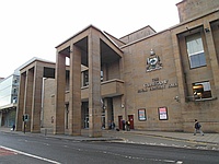
- The CCA (Centre for Contemporary Arts) is located across Sauchiehall Street here, with a pedestrian crossing used to cross the road and a two-way cycle lane in the centre of the wide pavement in front of CCA. There is an entrance to the CCA near its internal Saramago terrace bar, which is stepped off the now steep Pitt Street, into the first floor level. The main entrance is slightly further along Sauchiehall Street and offers step-free access and a lift to the first floor. There are also accessible toilets on the ground and first floors in the CCA, please refer to the separate access guide for full details.
CCA (Centre for Contemporary Arts) to Nice N Sleazy
- Nice N Sleazy is around 250m further down Sauchiehall Street from the CCA on the opposite side. To cross back over, the pedestrian crossing near Pitt Street can be used again or there are zebra crossings over the cycle lanes further to the right, leaving the one-way road to cross where safe.
- There is a junction with Holland Street which crossing is similar to the Pitt Street/Douglas Street junctions. Traffic is one-way coming towards Sauchiehall Street. Hengler’s Circus Wetherspoons is located on the far side of this junction and there may be outdoor seating in front of the venue making the wide pavement narrower. There are further benches to the right of the pavement beyond this on the way towards the next junction at Elmbank Street, diagonally opposite the large art deco Beresford building. Crossing Elmbank Street is similar again, it is one-way with any traffic entering the junction from Sauchiehall Street. There are some widely spaced narrow bollards on the opposite side to be aware of.
- The Garage venue is located across the street here, with a yellow truck coming out of the wall above its doors, before Nice N Sleazy on the left.
Nice N Sleazy to King Tut’s Wah Wah Hut
- Exiting Nice N Sleazy the tour heads back to the right long Sauchihall Street and follows the pavement round onto Elmbank Street. The surface changes to block paving at the crossing of Sauchiehall Lane area, beyond which there may an A-frames and outdoor seating at a café. At the Bath Street crossroads the pedestrian crossing to the left over Elmbank Street to The Griffin on the corner is used before crossing Bath Street. The wide corner space on the far side is used for a talking point about The Griffin and King’s Theatre opposite, before following Bath Street to the left.
- There is a concrete surface with an easy incline along to the junction with Holland Street and beyond to the next junction at Pitt Street around 200m away. Pitt Street is crossed at the traffic lights turning right in front of the Adelaide Place venue.
- Pitt Street has an incline upwards for around 150m crossing Bath Lane, West Regent Street and Douglas Lane, before reaching the summit at West George Street. After crossing West George Street there is a moderate to steep slope down for around 100m to St Vincent Street. It is steep and uneven around the St Vincent Lane junction crossing, although the opposite side of the road can be used to bypass this, with a less steep slope down, crossing back over at the traffic lights.
- Turning left onto St Vincent Street leads up another easy slope for around 35m until the final venue King Tut’s Wah Wah Hut is reached where the tour concludes. There are steps or a portable ramp to access the entrance and bar area, for full details please refer to the separate access guide.
Access Guides Available For (Nearby Venues and Tour Features)
- Shopping View
- Eating and Drinking View
-
Leisure and Entertainment
View
- Glasgow Royal Concert Hall - To view the access guide please click here (new tab).
- Pavilion Theatre - To view the access guide please click here (new tab).
- Theatre Royal - To view the access guide please click here (new tab).
- National Piping Centre - To view the access guide please click here (new tab).
- Glasgow Film Theatre - To view the access guide please click here (new tab).
- Adelaide Place - To view the access guide please click here (new tab).
- CCA (Centre for Contemporary Art) - To view the access guide please click here (new tab).
- Car Parks View
Accessible Toilet
- There are accessible toilets located within the Royal Concert Hall starting point and in the CCA (Centre for Contemporary Arts) around halfway. Please refer to the separate venue guides for full details.
- Tour organisers will be able to advise on further accessible toilet facilities within other venues near to the route.
Standard Toilet(s)
- All four venues visited on the tour offer standard toilets.
- Tour organisers will be able to advise on further toilet facilities.
Additional Info
- Documents are not available in Braille.
- Documents can be requested in large print.
- A bowl of water can be provided for an assistance dog.
- An assistance dog toilet area can be provided onsite.
- The assistance dog toilet area is located at various points throughout the tour.
- A member of staff trained in BSL skills is not normally on duty.
- This service cannot be requested.